Starting point: The Krma Valley (930 m)
| Lat/Lon: | 46,3851°N 13,9071°E |
| |
Time of walking: 4 h 30 min
Difficulty: very difficult pathless terrain
Altitude difference: 1295 m
Altitude difference po putu: 1300 m
Map: Triglav 1:25.000
Recommended equipment (summer): helmet
Recommended equipment (winter): helmet, ice axe, crampons
Views: 15.253
 | 3 people like this post |
Access to the starting point:
Leave the Gorenjska motorway at the Hrušica exit and follow the road towards Kranjska Gora. Just before the village of Dovje, the road branches off to the left and leads to Mojstrana (Vrata, Kot and Krma). Follow the road in the direction of the village of Radovna and the valleys of Krma and Kot. The relatively steep road then takes us past the TNP signboard, after which the road soon lays down and leads us to a crossroads where the macadam road to the valley of Kot branches off to the right. Continue straight ahead on the road, which begins to descend. In the middle of the descent, the road to the Krma valley branches off to the right (straight ahead Radovna). A little further on, you come to the next crossroads, where you continue to the right in the direction of Krma. The macadam road then leads to Kovinarska hut, and we follow it further. Occasionally, a slightly worse road then leads us to the parking lot in front of the gate.
Path description:
From the parking lot, continue past the ramp and follow the forest road, which is closed to public traffic. The minor road continues for a while over extensive gravel, then turns slightly right, where it enters the forest and turns into a rocky cart track. The path climbs gently through the forest for some time, and then, after crossing a slightly larger torrent, it begins to climb steeply through the dense forest. Higher up, the path leaves the forest into lane of dwarf pines, mixed with scrub, and climbs over the above-mentioned slope on rubble. At an altitude of about 1400 m the path lies down and after a further walk of a few 10 steps leads to a beautiful grassy plain called Vrtača.
On the other side of the plain, the wide path starts to climb again and after about 20 minutes of further walking leads us to Malo polje, where it turns to the right and leads us to a less conspicuous crossroads.
Continue left in the direction of Vodnikov dom (Planika and Kredarica on the right) along the path, which quickly begins to climb, first through a larch forest and then up through scree. The scree path becomes steeper and steeper and is dangerous to slip on in the snow that stays here until mid-summer. The narrowness of the last part of the route to Bohinjska vratca also increases the risk of falling rocks.
From Bohinjska vratca continue right on an unmarked path leading up a grassy slope. The grassy slope becomes steeper and steeper and is very dangerous for slipping, especially in wet conditions. Follow the steep track slightly to the left of the ridge up to a grassy headland at 2183m.
From the summit, continue along the ridge, initially descending steeply for a few metres on a rocky slope. Continue along the ridge, which becomes quite narrow and exposed. Walk mainly on the left side of the ridge, with some cairns indicating the direction. There are a few more very short climbing spots (level I-II) and we are already at the top of Vernar.

Pictures:
 1
1 2
2 3
3 4
4 5
5 6
6 7
7 8
8 9
9 10
10 11
11 12
12 13
13 14
14 15
15 16
16 17
17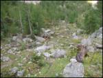 18
18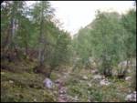 19
19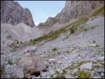 20
20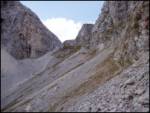 21
21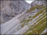 22
22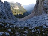 23
23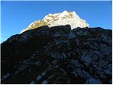 24
24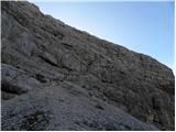 25
25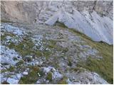 26
26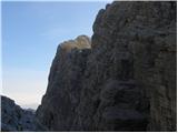 27
27 28
28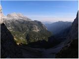 29
29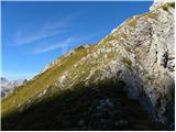 30
30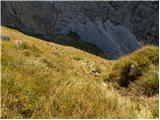 31
31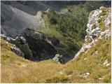 32
32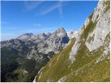 33
33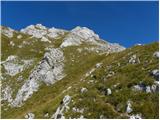 34
34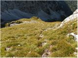 35
35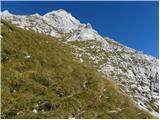 36
36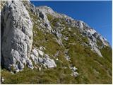 37
37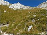 38
38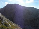 39
39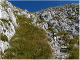 40
40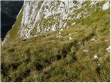 41
41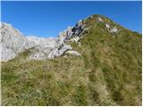 42
42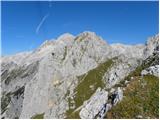 43
43 44
44 45
45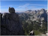 46
46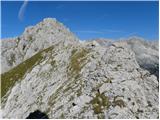 47
47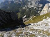 48
48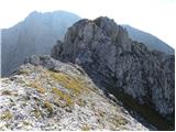 49
49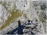 50
50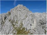 51
51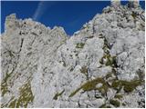 52
52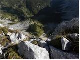 53
53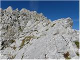 54
54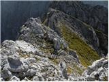 55
55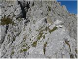 56
56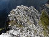 57
57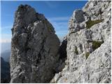 58
58 59
59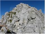 60
60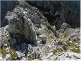 61
61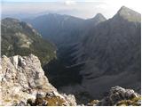 62
62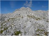 63
63
Discussion about the trail The Krma Valley - Vernar
|
| velkavrh1. 04. 2012 |
Lani poleti sem šel to pot. Prišel pa sem samo do predvrha Vernerja. Tisti spust s predvrha na greben je zgleda res malo težaven. Bi šel naprej, vendar je pihal močan veter in rahlo je začelo rositi, tako, da sem se hitro spustil po malo vlažnih drsečih travah dol k Vodnikovi. Vreme se je umirilo in sem šel naprej na planino in od tam na Doliča. Ob kakšnem lepem poletnem vremenu mislim Vernerja res osvojiti.
|
|
|
|
| Jonny_29. 08. 2012 |
Obiskal v petek, 24.8.2012. Menim, da pot niti ne bi bila potrebna biti klasificirana kot zelo zahtevna. Na koncu, ampak res na koncu, zadnjih 5-10 minut se je treba malo prijeti z roko. Pred tem zadnjim delom je 5 minut grebena - ni za vrtoglave. Sicer pa je pot lepo uhojena. Drži, da v mokrem zna biti precej neprijetna. Tudi "brezpotje" za to turo ni ravno beseda na mestu, saj je do Bohinjskega sedla pot markirana, to je cca. 3/4 poti, s sedla pa se nato usmeriš desno in kmalu za tem vidiš vrh, tako da nimaš kaj zgrešiti - samo slediš uhojeni stezi. Sam sem iz Krme do Malega polja s hitrejšim tempom rabil 1,5 ure, z Malega polja do Bohinjskega sedla 1 uro in 5 minut (realno je npr. 45 min), s sedla do vrha si lahko v pol ure, jaz sem imel čas, tako da sem šel počasi in z užitkom - rabil sem slabo uro. Skupaj torej 3 ure in pol, s počasnim tempom. Vernar je vreden obiska, če imate v hribih radi mir. Na poti nisem srečal nikogar, na vrhu, ki je dokaj prostoren, sem bil dobri dve uri povsem sam. Z vrha, kjer je velik možic je zelo lep pogled na Triglav. Če ste na vrhovih radi bosi, vzemite s sabo natikače, saj po tleh bode.  S to turo boste ugotovili, če so vam všeč brezpotja. Videli pa boste tudi veliko gamsov ter svizcev. SLIKE
|
|
|
|
| _sandra_29. 08. 2012 |
@Jonny: "S to turo boste ugotovili, če so vam všeč brezpotja.".. težko, glede na to, da je 3/4 poti markirane, kot si omenil zgoraj..? To potem ni ravno brezpotje 
|
|
|
|
| ljubitelj gora29. 08. 2012 |
Itak, da je brezpotje, le da bi tu moralo biti zahtevno brezpotje.
|
|
|
|
| Alfista29. 08. 2012 |
Markirana je do sedla, od tam naprej je pa na goro kar brezpotje.
|
|
|
|
| _sandra_29. 08. 2012 |
sem prebrala ja, da je od sedla brezpotje...in to zelo zahtevno..
|
|
|
|
| J.P.31. 07. 2018 |
Pot opravljena včeraj.Brezpotje je od Bohinjskih vratc do vrha Vernarja. Do oznake za Vodnikov dom je pot zelo dobro markirana. Pol je potrebno le malo pozornosti (možici) do melišča kjer nas čaka spet zelo dobro uhojena pot. Brezpotje je zahtevno ni pa zelo zahtevno. Kot je Johhny napisal, nekaj minut grebenske hoje in dva detajla za roke stegnit (I-II). Snega na poti po melišču ni. Srecno.
|
|
|
|
| J.P.31. 07. 2018 |
p.s- čelado pa kar imejte s seboj. Če ne drugega s Tošca letijo kamni glih v vratcih.
|
|
|
|
| bumbi31. 07. 2018 |
Grebena ni za podcenjevati. Je zračen na obe strani in krušljiv. Ni za vsakega. Vernarjev sosed je Tosc.
|
|
|
|
| tango4. 08. 2022 15:56:24 |
Danes sva z ženo obiskala dolgo načrtovan Vernar. Seveda je bilo, ob takem vremenu kot je danes, čudovito.Odcep na Malem polju je bolj za stezosledce, saj je napis Vodnikov dom na večjem balvanu povsem zbledel, nadaljevanje pa potem dokaj enostavno, še senco je metal Tošč kar nekaj časa, da ni bilo preveč toplo.Sam vzpon z Bohinjskih vratc je bil v suhem bp, po pobočju s celimi plahtami krasnih planik, od predvrha naprej pa za naju kar zahteven. Pa še to, poleg naju še en obiskovalec, ko pa sva se vračala, sva se od Malega polja do "Psnakove štale" samo čudila, kakšni pohodniki, oprema, fizična pripravljenost,se odločajo, da jo mahnejo na Triglav.
|
|
|