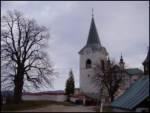
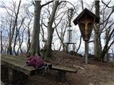
 | Topol - Sveti Jakob
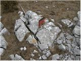
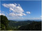
The Church of St James is located on a hill north of the village of Topol near Medvode. From the top, where there is a registration box with a st...
40 min |
| Topol - Sveti Jakob (via homestead Na Vihri)
The Church of St James is located on a hill north of the village of Topol near Medvode. From the top, where there is a registration box with a st...
45 min |
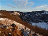
 | Rovišče - Zasavska Sveta gora (by road)
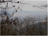
Zasavska Sveta gora is a popular excursion point located between Litija and Izlaki. From the top, where the parish church of the Nativity of the ...
35 min |
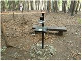
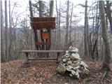
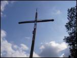 | Topol - Jeterbenk
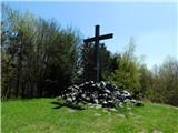
Jeterbenk is a 774 m high peak located between Slavko's home at Gole Brdo and Katarina (Topol village). From the top, where there is a large cros...
45 min |
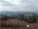
 | Praproče - Mali vrh
To the west of Polhov Gradec, between the rivers Mala voda and Velika Božna, is a 708-metre-high hill called Mali vrh. From the grassy summit, wh...
35 min |
 | Smrečje - Vrh Svetih Treh Kraljev (by road)
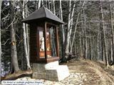
The Church of the Holy Three Kings is situated on a lookout above the village of Vrh Svetih Treh kraljev. From the top, which has an observation ...
45 min |
 | Smrečje - Vrh Svetih Treh Kraljev (footpath)
The Church of the Holy Three Kings is situated on a lookout above the village of Vrh Svetih Treh kraljev. From the top, which has an observation ...
40 min |
| Smrečje - Vrh Svetih Treh Kraljev (via Jereb)
The Church of the Holy Three Kings is situated on a lookout above the village of Vrh Svetih Treh kraljev. From the top, which has an observation ...
45 min |
 | Vrbiški dol - Srednji vrh at Kozlek
Srednji vrh is a scenic mountain located west of Ilirska Bistrica, near the better known Kozlek. From the top there is a beautiful view down to t...
40 min |
 | Zagreben (pri Dikcu) - Dom na Šmohorju
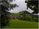
Dom na Šmohorju is located between Laško, Liboje and Zabukovica. From the house, or from the Church of St. Mohorj, a few minutes away, there is a...
45 min |
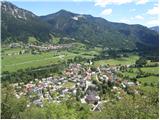
 | Tržič - Sveti Jurij above Tržič
The Church of St George, built in the 15th century, is situated on a small hill above Tržič or Bistrica near Tržič. The first Bishop of Ljubljana...
40 min |
 | Veliko Trebeljevo - Kucelj
Kucelj is a 748m high peak located north of Višnja gora. From the top of the peak there is a small geodetic tower with a stamp, which offers a be...
45 min |
 | Velika vrata - Velika Plešivica
Velika Plešivica is a 908 m high peak located between Slavnik and the less known Mala Plešivica. From the top of the summit, where the destroyed ...
25 min |
 | Zgornja Javoršica - Murovica
Murovica is a popular excursion point, accessible from the Posavina side, Domžale or from the Moravška valley. There is a bench and a registratio...
25 min |
| Križevska vas - Murovica
Murovica is a popular excursion point, accessible from the Posavina side, Domžale or from the Moravška valley. There is a bench and a registratio...
45 min |
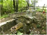
 | Jesenice (Ukova) - Kalvarija above Jesenice
Calvary is a popular point or peak above the town of Jesenice, known either as a kind of short "pilgrimage" route for the faithful, or as a short...
25 min |
 | Zavratec - Medvedje Brdo
Medvedje Brdo is a small settlement located north of Hotedršice. The highest point of the village is a pleasant lookout point located on Šinkovco...
45 min |
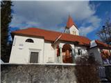
 | Suhi Dol - Sveti Andrej (Planina above Horjul)
The Church of St Andrew is situated on a lookout hill just above the Mountain pasture above Horjul. The church, which was built in 1659, offers a...
25 min |
 | Dom na Govejku - Gontarska planina
Gontarska planina is an 894 m high mountain located between Osolnik and Tosce. From the top, where there are two benches, we have a beautiful vie...
35 min |
 | Belo - Goljek
Goljek is an 809 m high peak located east of Polhograjska Grmada. The view from the summit, which is home to the remains of a former watchtower o...
40 min |
| Topol - Goljek (on west ridge)
Goljek is an 809 m high peak located east of Polhograjska Grmada. The view from the summit, which is home to the remains of a former watchtower o...
30 min |
 | Rakitna - Rotovc
Rotovc is a 964 m high peak located northeast of Rakitna. From the top, where a wooden bench stands, we have a beautiful view towards the already...
30 min |
 | Trebež (Jesenice) - Kozjek (on east ridge)
Kozjek is a 766 m high, easily accessible, ridge-like peak of the Jelenkamn fothills, which makes it part of the southern Karavanke fothills, and...
30 min |
 | Čepulje - Špičasti hrib
Špičasti hrib (Špičasti vrh on maps) is an 837 m high peak located to the west of Sveti Jošto above Kranj. There is no view from the top, which h...
40 min |
 | Podlanišče - Veliki vrh (Lajše)
Veliki vrh is an almost 900 m high peak rising south of Cerkno. From the top, where there are several television and radio transmitters covering ...
40 min |
 | Hunting sports association Vinska Gora - Temnjak
Temnjak (on some maps also written Vinska gora, but this is a neighbouring hill) is a 798 m high peak located north of the village Prelska near V...
25 min |
 | Hunting sports association Vinska Gora - Vinska gora
Vinska gora, marked on some maps as neighbouring Temnjak, is an 806 m high hill located north-west of Dobrnež and north-east of Vinská Gora. The ...
40 min |
 | Srednje - Globočak
Globočak is an 809 m high peak located in the Kanalski Kolovrat mountain range. The summit, which contains some remnants of the First World War, ...
35 min |
 | Mojstrana - Grančišče (south path)
Grančišče (also Grančiše) is a small precipitous peak rising west to south-west of Mojstrana. From the top, where there is a bench and a table, w...
25 min |
 | Pivka - Primož
Primož is a 718 m high peak located south to south-east of Pivka. Due to its ideal location overloking the entire Pivka basin, the Italians built...
25 min |
 | Zagorje - Šilentabor
Šilentabor is a 751 m high peak located just above the village of the same name. From the top, near which there is also a bench and a registratio...
35 min |
 | Žusem Castle - Žusem
Žusem is a 669-metre-high hill with a colourful history and great potential for the future. It represents the northern edge of the Kozjansko regi...
30 min |
 | Cenc - Špiček (Špečk)
Špiček (locals call it Špečk) is a peak located north to north-east of Cola. On the summit is a cross in honour of St Hubert and commemorating th...
45 min |
 | Travnarjev gozd (Hotenjsko podolje) - Sveta Barbara (Ravnik pri Hotedršici)
The Church of St Barbara is situated on a hill overloking the village of Ravnik near Hotedršice. From the church or its immediate surroundings, w...
35 min |
 | Možjanca - Apnišče
Apnišče is a 740 m high mountain located between Možjanca and Štefanja gora. It is the highest point of the Šenčur municipality. There is a bench...
35 min |
 | border crossing Remšnik - Sveti Pankracij (Radelca)
The Church of St Pancras on Radelca is located on the border ridge between Slovenia and Austria, but since 1966, following an inter-state agreeme...
25 min |
 | Zajasovnik - del (Strmce, chapel) - Jasovnik (Motnik tourist trail)
Jasovnik is a hill better known to all of us as the A1 motorway tunnel. The hill is located near Trojany. It has two peaks: the Little Jasovnik a...
45 min |
| Stružnica - Kuželjska stena
Kuželjska stena rises majestically above the village of Kuželj in the Kolpa valley. It is a rise in a fault that winds above the upper Kolpa vall...
45 min |
 | Planina pri Sevnici - Sveti Križ (above Planina pri Sevnici) (via Pravljični gozd)
The Church of the Holy Cross is located above Planina pri Sevnici, near the settlement of Šentvid at Mountain pasture. From the top, you have a b...
28 min |
 | Waldgebiet - Großer Hirschenstein
...
30 min |