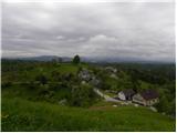
 | Lokvica - Fajti hrib
Fajti, according to some records also Fajti hrib, is a 433 m high peak located in the ridge of the Black Hills. The summit, which is known mainly...
1 h |
 | Ljubljana (Gruberjeva brv) - Mazovnik (Golovec)
At 450 m, Mazovnik is the highest peak of Golovec, a hill located in the south-eastern part of Ljubljana. Golovec was unforested until the end of...
1 h |
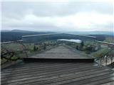
 | Sotina - Sotinski breg (Kugla) (via the source of mineral water)
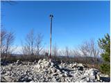
Sotinski breg or Kugla is the highest peak in Prekmurje at 418 m. From the top, which has a wooden lookout tower with a bell and a cross on it, y...
50 min |
 | Zazid - Kuk
Kuk (also Ščukovec on some maps) is a 498 m high hill located north of the village of Movraž. From the top, where a small cross stands, you can e...
1 h |
 | Komare doline - Sveti Kvirik
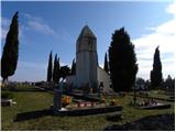
The church or chapel of St.Kvirik (on maps and elsewhere we can also find names such as St.Kirk, Kirik, Kvirk, Kvirin, Kirin) is located on the l...
1 h 20 min |
 | Phliški bajer - Mengeška koča on Gobavica (ridge path)
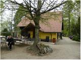
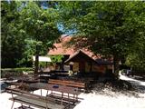
Gobavica is a hill rising above Mengeš. There is a Mengeš hut on the hill, and they also have a goat stall. It is one of the starting points for ...
1 h 10 min |
 | Phliški bajer - Mengeška koča on Gobavica (lower path)
Gobavica is a hill rising above Mengeš. There is a Mengeš hut on the hill, and they also have a goat stall. It is one of the starting points for ...
1 h |
 | Šentilj v Slovenskih goricah - Plački vrh
Plački vrh is a peak in Slovenske Gorice. It lies in the municipality of Kungota, right on the border with Austria.It has a 28-metre-high lookout...
1 h |
 | Gaber pri Semiču - Smuk (via Semenič)
Smuk is a 545-metre-high peak located above Semič. On the top there is the Church of St. Lawrence, a hunting lodge, and a little further away the...
1 h 10 min |
| Gaber pri Semiču - Smuk (via Smuška cesta)
Smuk is a 545-metre-high peak located above Semič. On the top there is the Church of St. Lawrence, a hunting lodge, and a little further away the...
50 min |
 | Kamnik - Sveta Ana (Tunjice)
The Baroque church of St Anne in Tunjice is located on a hill west of Kamnik. Near the church there is a registration box, and a little further a...
1 h |
| Vratca - Štanjel (Sveti Danijel) (Vratca - Sv. Danijel (Štanjel))
Štanjel (Sveti Danijel) is located east of Škabrijel (646 m). On the summit are the remains of WWI positions and trenches. On the top there is a...
1 h |
 | Ljubljana (Žabja vas) - Orle
Orle is a locality in the municipality of Lavrica, located on a small hill northeast of the Ljubljana Mor. A few metres below the highest point o...
1 h 15 min |
| Ljubljana (Sveti Urh) - Orle
Orle is a locality in the municipality of Lavrica, located on a small hill northeast of the Ljubljana Mor. A few metres below the highest point o...
1 h 10 min |
 | Rdeči Kal - Ostri vrh (above Globodol) (via Dom LD Dobrnič)
Ostri vrh is a 523 m high peak located between Vrbovec, Rdeči Kal, Gorenji, Sredni and Dolenji Globodol, Dolni and Gorni Ajdovec and Podlipa. The...
1 h |
 | Suhadole - Koseški hrib (via Mlinčki)
Koseški hrib is located between Kuharjevi boršt' and Kosezami, the settlement after which the peak is named. From the top, where there is a table...
50 min |
| Bukovica pri Vodicah - Koseški hrib (via Mlinčki)
Koseški hrib is located between Kuharjevi boršt' and Kosezami, the settlement after which the peak is named. From the top, where there is a table...
50 min |
 | Topole - Koseški hrib
Koseški hrib is located between Kuharjevi boršt' and Kosezami, the settlement after which the peak is named. From the top, where there is a table...
55 min |
 | Vojnik - Sveti Tomaž above Vojnik
St.Thomas is a church standing on a partially vegetated 444 m high peak near Vojnik. On the top there is a registration book with a stamp. Below ...
1 h |
 | Liboje - Kamčič (via organic farm Kralj - southern approach)
Kamčič is a vegetated peak in Posavsko hribovje, located north of Šmohor, between Kotečnik on the left and Veliki Slomnik on the right. It can be...
1 h 10 min |
 | Brezje pri Dobrovi - Vrhovčev grič (čez Strmco)
Vrhovčev grič is a nondescript and forested peak located only a few metres away from the marked path between Debeli hill and Strmca....
50 min |
| Dragomer (bajer) - Vrhovčev grič (mimo Ferjanke in čez Strmco)
Vrhovčev grič is a nondescript and forested peak located only a few metres away from the marked path between Debeli hill and Strmca....
1 h 10 min |
 | border crossing Kramarovci - Sveta Ana pri Igu / Sankt Anna am Aigen
...
1 h |
 | border crossing Matjaševci - Holzmannkogel
...
1 h 15 min |
 | Borovic (cesta na Hum) - Sveti Duh (Hum) (mimo Titove špilje)
...
50 min |