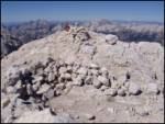
 | Gozdec - Prestreljenik (via dom Petra Skalarja)
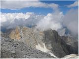
Prestreljenik is a 2499 m high mountain located in the heart of the Kanin Mountains. From the top, where the Aljaž Tower-shaped registration box ...
5 h 45 min |
| B station - Prestreljenik (via Krnica)
Prestreljenik is a 2499 m high mountain located in the heart of the Kanin Mountains. From the top, where the Aljaž Tower-shaped registration box ...
4 h 25 min |
 | Sella Nevea - Koštrunove špice (via Forcella Lavinal dell Orso)
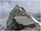
Koštrunove špice is a 2502 m high peak located south-west of Viš (2666 m). The summit offers a beautiful view over most of the western Julian Alp...
4 h 30 min |
 | Aljažev dom v Vratih - Triglavski dom na Kredarici (via Prag)
Triglavski dom na Kredarici is Slovenia's highest mountain hut. It is open all year round but only on an emergency basis out of season. From the ...
5 h |
 | The Kot Valley - Triglavski dom na Kredarici
Triglavski dom na Kredarici is Slovenia's highest mountain hut. It is open all year round but only on an emergency basis out of season. From the ...
5 h |
| end of road on Pokljuka - Triglavski dom na Kredarici
Triglavski dom na Kredarici is Slovenia's highest mountain hut. It is open all year round but only on an emergency basis out of season. From the ...
5 h |
| Rudno polje - Triglavski dom na Kredarici
Triglavski dom na Kredarici is Slovenia's highest mountain hut. It is open all year round but only on an emergency basis out of season. From the ...
5 h 20 min |
| Uskovnica (Lom) - Triglavski dom na Kredarici (via Planina Spodnji Tosc)
Triglavski dom na Kredarici is Slovenia's highest mountain hut. It is open all year round but only on an emergency basis out of season. From the ...
5 h 35 min |
| Uskovnica (Razpotje) - Triglavski dom na Kredarici (via planina Spodnji Tosc)
Triglavski dom na Kredarici is Slovenia's highest mountain hut. It is open all year round but only on an emergency basis out of season. From the ...
5 h 30 min |
 | The Kot Valley - Rjavina (ridge way)
Rjavina is located between two Alpine valleys. The two valleys are Kot and Krma. From the summit, which has a registration book, there is a very ...
6 h |
| Aljažev dom v Vratih - Rjavina (via Prag)
Rjavina is located between two Alpine valleys. The two valleys are Kot and Krma. From the summit, which has a registration book, there is a very ...
6 h 30 min |
| Dolina Krma - Rjavina (ridge path)
Rjavina is located between two Alpine valleys. The two valleys are Kot and Krma. From the summit, which has a registration book, there is a very ...
6 h 45 min |
| End of road on Pokljuka - Rjavina
Rjavina is located between two Alpine valleys. The two valleys are Kot and Krma. From the summit, which has a registration book, there is a very ...
7 h 30 min |
| Rudno polje - Rjavina
Rjavina is located between two Alpine valleys. The two valleys are Kot and Krma. From the summit, which has a registration book, there is a very ...
7 h 50 min |
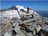
 | V Koncu - Skuta (via Kokrsko sedlo)
Skuta is a 2532 m high mountain located in the heart of the Kamink Savinja Alps. From the top, where there is a registration box and a stamp, we ...
5 h 30 min |
| Suhadolnik - Skuta (via Kokrsko sedlo)
Skuta is a 2532 m high mountain located in the heart of the Kamink Savinja Alps. From the top, where there is a registration box and a stamp, we ...
5 h 45 min |
 | Suhadolnik - Grintovec (via Streha)
Grintovec is the highest peak in the Kamnik and Savinja Alps. It is located above the valley of Kamniška Bistrica, Suhi dol and above the valley ...
4 h 45 min |
 | Aljažev dom v Vratih - Kanjavec
Kanjavec is a 2569 m high mountain located between Dolič and Hribarice. From the top, which has a registration box and a stamp, we have a beautif...
7 h 10 min |
 | Aljažev dom v Vratih - Dolkova špica (western way)
Dolkova špica is a 2591 m high mountain located between Stenar and Škrlatica. From the summit, where the registration box is located, you can enj...
5 h 15 min |
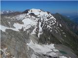
 | Sella Nevea - Viš/Jof Fuart
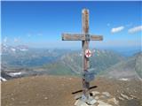
Viš is a 2666m high peak in the western Julian Alps. From the top, where the statue of St Mary and the cross stand, you can enjoy a beautiful vie...
5 h |
| Cave del Mole - Viš/Jof Fuart
Viš is a 2666m high peak in the western Julian Alps. From the top, where the statue of St Mary and the cross stand, you can enjoy a beautiful vie...
4 h 30 min |
 | Pri Mlinču - Mangart (italijanska pot)
Mangart (also Mangrt, both spellings are grammatically correct) is a mountain that receives a very high number of visitors in summer. Access to t...
4 h 45 min |
 | Plockenpass - Cima di Mezzo / Keller Warte (via Rifugio Marinelli)
The Cima di Mezzo (German: Keller Warte) is a 2713-metre-high mountain in Carnic Alps on the border between Austria and Itali. There is a small c...
4 h 35 min |
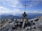
 | Plockenpass - Monte Coglians (Hohe Warte) (via Rifugio Marinelli)
At 2780 metres, Monte Coglians is the highest mountain in the Carnic Alps. From the top, where the cross and the bell stand, you have a very nice...
5 h |
| Untere Valentinalm - Monte Coglians (Hohe Warte) (via Wolayer See)
At 2780 metres, Monte Coglians is the highest mountain in the Carnic Alps. From the top, where the cross and the bell stand, you have a very nice...
5 h 30 min |
| Rifugio Tolazzi - Monte Coglians (Hohe Warte) (via Rifugio Marinelli)
At 2780 metres, Monte Coglians is the highest mountain in the Carnic Alps. From the top, where the cross and the bell stand, you have a very nice...
4 h 25 min |
 | Ehrwald - Zugspitze (via Gatterl)
At 2962 metres, Zugspitze is the highest peak in the Wetterstein mountain group and the highest peak in Germany. The mountain is located south of...
7 h 30 min |
 | Alba di Canazei - Cima Ombretta (via Passo Ombretta)
Cima Ombretta is a 3011-metre peak in the Marmolada mountain group. The summit on which the cross stands offers the best view of the nearby south...
5 h |
| Malga Ciapela - Cima Ombretta (via Passo Ombretta)
Cima Ombretta is a 3011-metre peak in the Marmolada mountain group. The summit on which the cross stands offers the best view of the nearby south...
4 h 40 min |
 | Lenzanger - Goldzechkopf
Goldzechkopf is a 3,042-metre peak in the Goldberg Mountain Group. The peak is located on the ridge between the better known Hoher Sonnblick and ...
5 h 10 min |
 | Rifugio Pederü - Lavarella
Lavarella (aka La Varella) is the second highest peak in the Lavarella mountain group. From the summit on which the cross stands, you have a very...
5 h |
 | Lenzanger - Hoher Sonnblick
Hoher Sonnblick aka Rauriser Sonnblick is a 3106 metre high mountain in the Goldberg mountain group. The Zittelhaus hut and the highest meteorolo...
5 h |
 | San Martino - Cima Vezzana (via Rifugio Rosetta)
At 3192 metres, Cima di Vezzana is the highest peak in the Pale di San Martino mountain group. The summit offers a very fine view over most of th...
6 h 20 min |
 | Mallnitz - Ankogel
At 3252m, Ankogel is one of the highest peaks in its group of mountains (Ankogel gruppe). Only Hochalmspitze (3360m) and Großetendk (3317m) are h...
7 h |
 | Lenzanger - Hocharn
Hocharn (also Hoher Aar, Hochnarr) is the highest peak in the Goldberg Group at 3254 metres. The summit is situated on the border between Kärnten...
5 h 10 min |
 | Parkirišče Sulzenauhütte - Wilder Freiger (mimo Sulzenauhütte in preko sedla Seescharte)
Wilder Freiger (Cima Libera in Italian) is one of the best known and most visited peaks in the central part of the Stubai Alps summit range, the ...
7 h 15 min |