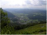
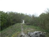
 | Briše - Polhograjska Gora (Sveti Lovrenc) (steep path)
Polhograjska Gora, also just Gora or Sveti Lovrenc, is an 824 m high hill located north-west of Polhov Gradec. From the top of the hill, where th...
1 h 30 min |
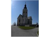 | Sotočje Male in Velike Božne - Sveti Lenart
The Church of St. Lenart is situated on a scenic hill in the immediate vicinity of Černý Vrch above Polhov Gradec. From the top, where there is a...
1 h 45 min |
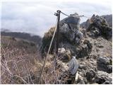 | Širje - Kopitnik
Kopitnik is a precipitous peak located north of Zidanega Most and south of Rimske Toplice. From the summit, which has a registration box, there i...
1 h 55 min |
 | Marno - Kopitnik
Kopitnik is a precipitous peak located north of Zidanega Most and south of Rimske Toplice. From the summit, which has a registration box, there i...
1 h 55 min |
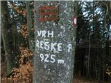 | Marija Reka (Strgarjev kamnolom) - Reška planina
Reška planina is a peak in Posavsko hribovje, located southwest of Prebold. The marked trail does not lead to the summit, but to a nearby viewpoi...
2 h 25 min |
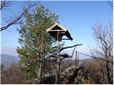
 | Griže - Kamnik (via Zahom)
Kamnik or Veliki vrh is a steep mountain in the Posavje hills. On the top there is a small bivouac of Stank Kotnik, which offers shelter in case ...
2 h 30 min |
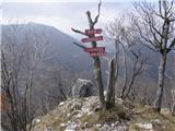
 | Marija Reka (Strgarjev kamnolom) - Golava (Ovčja pot)
Golava is a peak located north of Mrzlica. From the summit, on which a small bivouac (Blaž's bivouac) stands, there is a beautiful view towards t...
1 h 45 min |
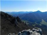
 | Zgornja Rečica (cerkev bl. Antona Martina Slomška) - Ostri vrh
To the north of Hrastnik, in the heart of Posavsko hribovje, rises a steep 855-metre-high peak called Ostri vrh. The view from the summit, which ...
1 h 55 min |
 | Dol pri Hrastniku - Ostri vrh
To the north of Hrastnik, in the heart of Posavsko hribovje, rises a steep 855-metre-high peak called Ostri vrh. The view from the summit, which ...
1 h 35 min |
| Hrastnik - Ostri vrh
To the north of Hrastnik, in the heart of Posavsko hribovje, rises a steep 855-metre-high peak called Ostri vrh. The view from the summit, which ...
1 h 40 min |
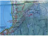
 | Novo Selo Okićko - Čerga (Plešivica)
Čerga (779 m) is the highest peak of Plešivica, a long ridge in the southern part of the Samobor Mountains, a kind of extension of Žumberacka Mou...
1 h 45 min |
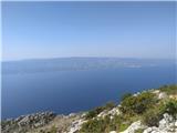
 | Weißenbach - Schoberstein
Schoberstein is a 1037 m high peak in the western part of the Höllengebirge above Attersee. The summit offers a beautiful view of the Attersee, t...
1 h 30 min |
 | Borak - Kula (Omiška Dinara)
...
1 h 45 min |