Similar trips - Prapretno pri Hrastniku - Church of the Holy Cross (Retje)
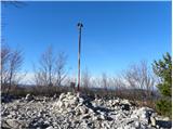
 | OMP Kuzma - Sotinski breg (Kugla)
Sotinski breg or Kugla is the highest peak in Prekmurje at 418 m. From the top, which has a wooden lookout tower with a bell and a cross on it, y...
1 h |
 | Zazid - Kuk
Kuk (also Ščukovec on some maps) is a 498 m high hill located north of the village of Movraž. From the top, where a small cross stands, you can e...
1 h |
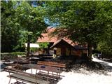 | Phliški bajer - Mengeška koča on Gobavica (lower path)
Gobavica is a hill rising above Mengeš. There is a Mengeš hut on the hill, and they also have a goat stall. It is one of the starting points for ...
1 h |
 | Gaber pri Semiču - Smuk (via Smuška cesta)
Smuk is a 545-metre-high peak located above Semič. On the top there is the Church of St. Lawrence, a hunting lodge, and a little further away the...
50 min |
 | Kamnik - Sveta Ana (Tunjice)
The Baroque church of St Anne in Tunjice is located on a hill west of Kamnik. Near the church there is a registration box, and a little further a...
1 h |
| Vratca - Štanjel (Sveti Danijel) (Vratca - Sv. Danijel (Štanjel))
Štanjel (Sveti Danijel) is located east of Škabrijel (646 m). On the summit are the remains of WWI positions and trenches. On the top there is a...
1 h |
 | Ljubljana (Sveti Urh) - Orle
Orle is a locality in the municipality of Lavrica, located on a small hill northeast of the Ljubljana Mor. A few metres below the highest point o...
1 h 10 min |
 | Suhadole - Koseški hrib (via Mlinčki)
Koseški hrib is located between Kuharjevi boršt' and Kosezami, the settlement after which the peak is named. From the top, where there is a table...
50 min |
| Bukovica pri Vodicah - Koseški hrib (via Mlinčki)
Koseški hrib is located between Kuharjevi boršt' and Kosezami, the settlement after which the peak is named. From the top, where there is a table...
50 min |
 | Vojnik - Sveti Tomaž above Vojnik
St.Thomas is a church standing on a partially vegetated 444 m high peak near Vojnik. On the top there is a registration book with a stamp. Below ...
1 h |
 | OMP Kuzma - Stadelberg
...
55 min |
 | Borovic (road on Hum) - Sveti Duh (Hum) (past Titova špilja)
...
50 min |
 | Snack Bar Zelena dolina - Church of Our Lady of Loreto in Ložno
...
1 h 5 min |
| Brzika - Church of Our Lady of Loreto in Ložno
...
55 min |
 | Buzet Railway Station - Pilj (nad Buzetom)
...
1 h |