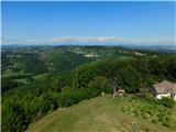
 | Ljubljana (Podutik) - Toško Čelo
Toško Čelo is a 590 m high hill above the village of the same name. From the top, or slightly lower down, you have a beautiful view of part of Lj...
1 h |
 | Za koridorjem - Sabotin (direct way)
Sabotin is hill above Nova Gorica or more accurate above Solkan. Altough its low attitude it is great outlook with sight to Julian Alps, river So...
1 h |
 | Za koridorjem - Sabotin (on ridge)
Sabotin is hill above Nova Gorica or more accurate above Solkan. Altough its low attitude it is great outlook with sight to Julian Alps, river So...
1 h 15 min |
 | Gojače - Školj Svetega Pavla above Vrtovin (past trough)
The St Paul's Collegium is located on a lookout above the village of Vrtovin, west of Ajdovščina. From the church, near which the registration bo...
1 h |
| Malovše - Školj Svetega Pavla above Vrtovin
The St Paul's Collegium is located on a lookout above the village of Vrtovin, west of Ajdovščina. From the church, near which the registration bo...
1 h 5 min |
 | Griže - Dragov dom na Homu (direct path)
Drago's home is located on a scenic hill, south of Šempeter. From the top, which is also the Church of St. Magdalene, there is a beautiful view f...
1 h 30 min |
| Šešče pri Preboldu - Dragov dom na Homu (via Lajnarjev hrib)
Drago's home is located on a scenic hill, south of Šempeter. From the top, which is also the Church of St. Magdalene, there is a beautiful view f...
1 h |
| Šešče pri Preboldu - Dragov dom na Homu (Brdovska pot)
Drago's home is located on a scenic hill, south of Šempeter. From the top, which is also the Church of St. Magdalene, there is a beautiful view f...
1 h 15 min |
 | Tremerje - Veliki Slomnik
Veliki Slomnik is a peak located between Košnica pri Celju and Liboje. There is no view from the summit, which has a registration box, due to the...
1 h |
 | Tremerje - Veliki Slomnik (Tremerje - Veliki Slomnik - Liboje)
Veliki Slomnik is a peak located between Košnica pri Celju and Liboje. There is no view from the summit, which has a registration box, due to the...
1 h 35 min |
 | Gorica pri Slivnici - Rifnik
Rifnik is a 568m high peak located south of Šentjur near Celje. The summit, which is famous for its archaeological site, offers a beautiful view ...
1 h 15 min |
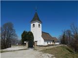
 | Lopata - Planinski dom Šentjungert
The mountain lodge is located just a few metres below the top of Gora, on which the Church of St Kunigunde, built in the 14th century, stands. Th...
1 h 30 min |
 | Lokvica - Veliki vrh (Črni hribi)
Veliki vrh is a 463 m high peak located in the ridge of the Black Hills. The summit, where the registration box is located, has no view due to th...
1 h 30 min |
 | Komare doline - Veliki Gradež
Veliki Gradež is a 507 m high hill located between Zazid and Movraz. From the top, set amidst vast pastures, you can enjoy a beautiful view of th...
1 h 30 min |
 | Pliskovica - Volnik
Volnik or Monte Lanaro in Italian is a 546 m high hill located near the village of Pliskovica in the Karst. It is topped by a small tower and off...
1 h 30 min |
 | Svečina - Plački vrh
Plački vrh is a peak in Slovenske Gorice. It lies in the municipality of Kungota, right on the border with Austria.It has a 28-metre-high lookout...
1 h 35 min |
 | Dragomer - Strmca (via Debeli hrib)
Strmca is a lesser-known and forested hill located between Brezje pri Dobrovi and Log pri Brezovici. There is no view from the top due to the for...
1 h 15 min |
 | Trebnje Castle - Trebni vrh (steep path via hunting cottage)
Trebni vrh is a 581-metre-high hill located south or south-west of Trebnje. On the top of the forested hill there is a bench, and near it there i...
55 min |
| Trebnje Castle - Trebni vrh (via caves and hunting lodge)
Trebni vrh is a 581-metre-high hill located south or south-west of Trebnje. On the top of the forested hill there is a bench, and near it there i...
1 h |
 | Zagorica pri Dobrniču - Lisec (Liška gora)
Lisec is a 565 m high peak located north to north-east of Žužemberk and south-west of Dobrnice. On the top of the peak stands a metal cross, to w...
1 h |
 | Tremerje - Vipota
Vipota is a 532-metre-high peak south of Celje, above the left bank of the Savinja. Approaches to the summit are possible from several directions...
1 h |
 | Zagrad - Vipota
Vipota is a 532-metre-high peak south of Celje, above the left bank of the Savinja. Approaches to the summit are possible from several directions...
1 h |
 | Zagrad - Vipota (via crossing Ivankovič)
Vipota is a 532-metre-high peak south of Celje, above the left bank of the Savinja. Approaches to the summit are possible from several directions...
1 h 15 min |
 | Bad Gleichenberg (Sägewerk Weiss) - Stradner Kogel
Stradner Kogel is the highest hill in south-eastern Styria. The hill is of volcanic origin, and its vegetation prevents views in any direction. O...
1 h 15 min |
| Haag - Stradner Kogel
Stradner Kogel is the highest hill in south-eastern Styria. The hill is of volcanic origin, and its vegetation prevents views in any direction. O...
1 h 10 min |
 | Zgornje Poljčane - Ljubična gora
Ljubična gora is a hill located above Ljubično, Zbelovo and Zbelovo Gora. The hill is hidden in the forest and is not very visible, but the churc...
1 h 15 min |
 | Velika Kostrevnica - Kožljevec
Kožljevec (also Kožlevec) is a 533 m high hill above Cerovica in the municipality of Šmartno pri Litija. The top, which also has a box with a reg...
1 h 10 min |
 | Lovska koča Muljava - Mali Petrovac (Petrova gora) (Roman path)
Mali Petrovac is a rather low hill located somewhere on the border between Banja and Kordun, Pannonian Croatia and Gorski Kotar. The top is compl...
1 h |
 | Hunting cottage Muljava - Mali Petrovac (Petrova gora) (via Mali Velebit)
Mali Petrovac is a rather low hill located somewhere on the border between Banja and Kordun, Pannonian Croatia and Gorski Kotar. The top is compl...
1 h 15 min |
 | Naraplje - Church of St. Bolfenk (Jelovice)
The Church of St. Bolfenko is situated on a 537-metre-high hill above Jelovice. From the top, you can enjoy a beautiful view of the Haloze and Bo...
1 h |
| Stogovci (Vabča vas) - Church of St. Bolfenk (Jelovice)
The Church of St. Bolfenko is situated on a 537-metre-high hill above Jelovice. From the top, you can enjoy a beautiful view of the Haloze and Bo...
1 h |
 | Stogovci (Vabča vas) - Kerješetov vrh
Kerješetov vrh is a 590-metre-high hill located above Jelovice. The hill is covered with forest, and the view is second to none....
1 h 30 min |
 | Podčetrtek (Terme Olimia) - Zavetišče Šmarnica na Mali Rudnici (mimo gradu Podčetrtek)
...
1 h 15 min |
| Podčetrtek (sveti Lovrenc) - Zavetišče Šmarnica na Mali Rudnici (mimo gradu Podčetrtek)
...
1 h 5 min |
| Podčetrtek (sveti Lovrenc) - Zavetišče Šmarnica na Mali Rudnici
...
1 h |
 | Slake (cerkev Device Marije na Pesku) - Zavetišče Šmarnica na Mali Rudnici
...
1 h 35 min |
 | Zgornje Poljčane - Rančka
...
1 h 25 min |