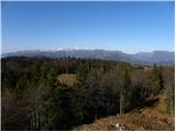
 | Dom v Dragi - Begunjščica (via Roblekov dom)
Begunjščica is a mountain range in Karawanks east of Stol. The highest peak is Veliki vrh, which at over 2000m offers a beautiful view of central...
4 h 20 min |
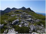
 | Matizovec - Veliki vrh (Košuta)
Veliki vrh, with a height of 2088 m, is the westernmost two-thousander in the longest Slovenian ridge - the Košuta. From the summit, where there ...
3 h 20 min |
 | Podljubelj - Veliki vrh (Košuta) (via Matizovec)
Veliki vrh, with a height of 2088 m, is the westernmost two-thousander in the longest Slovenian ridge - the Košuta. From the summit, where there ...
4 h 15 min |
 | Krnica - Debela peč
Debela peč is a 2014 m high mountain that rises steeply above the Krma valley on one side and descends gently towards the vast Pokljuka forests o...
5 h 30 min |
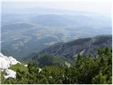
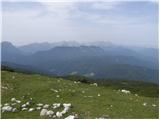
 | Laško - Storžič (via Javornik)
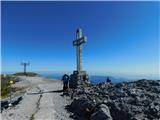
Storžič is a 2132 m high mountain located in the western part of the Kamink Savinja Alps. From the top with a cross there are beautiful views of ...
4 h 10 min |
 | Povlje - Storžič (through southwest groove)
Storžič is a 2132 m high mountain located in the western part of the Kamink Savinja Alps. From the top with a cross there are beautiful views of ...
4 h |
| Zalog - Storžič (below Psica and through southwest groove)
Storžič is a 2132 m high mountain located in the western part of the Kamink Savinja Alps. From the top with a cross there are beautiful views of ...
4 h 35 min |
| Zalog - Storžič (via Planina Javornik and through southwest groove)
Storžič is a 2132 m high mountain located in the western part of the Kamink Savinja Alps. From the top with a cross there are beautiful views of ...
4 h 30 min |
 | Bistra - Velika Raduha
At 2062 m, Velika Raduha is the highest peak of Raduha, a mountain range rising steeply to the east of Robanov Kot. From the summit, which has a ...
4 h 55 min |
| Tolminske Ravne - Tolminski Kuk (via Planina Kal)
Tolminski Kuk is the highest peak of the Lower Bohinj Mountains. The summit, which has a registration box, offers a very nice view. From the top ...
4 h |
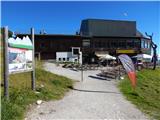
 | Zadnjica - Pogačnikov dom na Kriških podih
The hut is located on a panoramic hill in the Kriški Podi above Trenta. The hut, which is open in the summer season, also has a large winter room...
4 h |
 | Zadnjica - Zasavska koča na Prehodavcih
Zasavska koča na Prehodavcih is located on a scenic peak above the Triglav Lakes Valley. The hut, which is open in the summer season, offers a be...
4 h 15 min |
| Trenta - Zasavska koča na Prehodavcih
Zasavska koča na Prehodavcih is located on a scenic peak above the Triglav Lakes Valley. The hut, which is open in the summer season, offers a be...
4 h 15 min |
 | Poče - Porezen (winter way)
Porezen is a 1630 m high mountain located between Davča and Baška Grapa. From the top, where a large NOB monument stands, we have a beautiful vie...
3 h 25 min |
 | Mače - Srednji vrh (via Kozjek and Dolga njiva)
Srednji vrh is an 1853 m high mountain located to the east of Storžič. From the top, where there is a bench, a registration box and a stamp, we h...
3 h 30 min |
| Mače - Srednji vrh (Mačenska pot and via Cjanovca)
Srednji vrh is an 1853 m high mountain located to the east of Storžič. From the top, where there is a bench, a registration box and a stamp, we h...
3 h 50 min |
| Mače - Srednji vrh (Mačenska pot and via Dolga njiva)
Srednji vrh is an 1853 m high mountain located to the east of Storžič. From the top, where there is a bench, a registration box and a stamp, we h...
3 h 35 min |
| Mače - Srednji vrh (via Kozjek and Cjanovca)
Srednji vrh is an 1853 m high mountain located to the east of Storžič. From the top, where there is a bench, a registration box and a stamp, we h...
4 h |
 | Stara Fužina - Pršivec (direct way)
Lookout Mountain is located above Lake Bohinj. The view is extensive on all sides. Triglav and the mountains around it can be seen, and on the ot...
3 h 45 min |
 | Bašelj - Bašeljski vrh (via hospital Košuta)
Bašeljski vrh is a 1744 m high mountain located between Mali Grintovec and Storžič. From the top, where there is a bench and a registration box w...
3 h 25 min |
| Mače - Bašeljski vrh (via Kozjek)
Bašeljski vrh is a 1744 m high mountain located between Mali Grintovec and Storžič. From the top, where there is a bench and a registration box w...
3 h 30 min |
 | Poljana (Završnica) - Prešernova koča na Stolu (Žirovniška pot)
Prešernova koča na Stolu, is located just a few metres below the summit of the 2198 m high Mali Stol. From the hut or the nearby Mali Stol, we ha...
4 h 5 min |
 | Poljana (Završnica) - Prešernova koča na Stolu (Zabreška pot)
Prešernova koča na Stolu, is located just a few metres below the summit of the 2198 m high Mali Stol. From the hut or the nearby Mali Stol, we ha...
4 h 25 min |
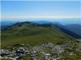
 | Grant - Rodica
The mountain is located above Bohinj in the Lower Bohinj Mountains. From the top there is a beautiful view of Julian Alps and Škofjeloško and the...
3 h 30 min |
| Stržišče - Rodica
The mountain is located above Bohinj in the Lower Bohinj Mountains. From the top there is a beautiful view of Julian Alps and Škofjeloško and the...
4 h 15 min |
 | Markova raven - Mokrica (marked way)
Mokrica is a scenic peak to the east of Kompotele. On the top, which is partly covered with dwarf pines, there is a registration book....
3 h 30 min |
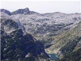
 | Koča pri Savici - Lanževica (via Bogatinsko sedlo)
Lanževica is a 2003 m high peak located between Bogatinsko sedlo and Oslovo Stub. The summit, on which the remains of the former Rapallo border s...
5 h |
| Koča pri Savici - Lanževica (via Lepa Komna)
Lanževica is a 2003 m high peak located between Bogatinsko sedlo and Oslovo Stub. The summit, on which the remains of the former Rapallo border s...
5 h |
 | Pod Zjabci - Lanževica (via Lepa Komna)
Lanževica is a 2003 m high peak located between Bogatinsko sedlo and Oslovo Stub. The summit, on which the remains of the former Rapallo border s...
5 h |
| Dom v Lepeni - Lanževica (via Bogatinsko sedlo)
Lanževica is a 2003 m high peak located between Bogatinsko sedlo and Oslovo Stub. The summit, on which the remains of the former Rapallo border s...
5 h |
 | Koča pri Savici - Mahavšček (via planina Govnjač)
Mahavšček or Big Bogatin is a 2008 m high mountain located on the north-western outskirts of the Lower Bohinj Mountains. From the top, where ther...
5 h |
 | Mojstrana - Sleme
The mountain is located between Mojstrana and Kukova Spica. The top is grassy and has a very nice view towards Kukova Spica. From the top there i...
4 h 15 min |
 | Mače - Mali Grintovec (via Bašeljski vrh)
Mali Grintovec is a lookout mountain located to the east of Storžiča. From the top, where there is a registration box, a stamp and a nice bench, ...
4 h |
| Mače - Mali Grintovec (via Kozjek and Dolga njiva)
Mali Grintovec is a lookout mountain located to the east of Storžiča. From the top, where there is a registration box, a stamp and a nice bench, ...
3 h 30 min |
| Laško - Mali Grintovec (via Bašeljski vrh)
Mali Grintovec is a lookout mountain located to the east of Storžiča. From the top, where there is a registration box, a stamp and a nice bench, ...
3 h 30 min |
| Mače - Mali Grintovec (Mačenska pot and via Dolga njiva)
Mali Grintovec is a lookout mountain located to the east of Storžiča. From the top, where there is a registration box, a stamp and a nice bench, ...
3 h 30 min |
| Bašelj - Mali Grintovec (via Bašeljski vrh)
Mali Grintovec is a lookout mountain located to the east of Storžiča. From the top, where there is a registration box, a stamp and a nice bench, ...
4 h |
| Bašelj - Mali Grintovec (via hospital Košuta and over Bašeljski vrh)
Mali Grintovec is a lookout mountain located to the east of Storžiča. From the top, where there is a registration box, a stamp and a nice bench, ...
4 h 10 min |
 | MHE Zabukovec - Mali Grintovec
Mali Grintovec is a lookout mountain located to the east of Storžiča. From the top, where there is a registration box, a stamp and a nice bench, ...
3 h 50 min |
| Mače - Mali Grintovec (via Dom na Kališču)
Mali Grintovec is a lookout mountain located to the east of Storžiča. From the top, where there is a registration box, a stamp and a nice bench, ...
3 h 45 min |
| Bašelj - Mali Grintovec (via Dom na Kališču)
Mali Grintovec is a lookout mountain located to the east of Storžiča. From the top, where there is a registration box, a stamp and a nice bench, ...
3 h 45 min |
| Bašelj - Mali Grintovec (via hospital Košuta and Dom na Kališču)
Mali Grintovec is a lookout mountain located to the east of Storžiča. From the top, where there is a registration box, a stamp and a nice bench, ...
3 h 55 min |
 | Rosenbach - Rosenkogel/Hruški vrh
Rosenkogel is a 1776 m high mountain located between Frauenkogel and the slightly less known Klek. From the top, where there is a small chapel de...
3 h 50 min |
 | Rosenbach - Rosenkogel/Hruški vrh (via Koprivnjak)
Rosenkogel is a 1776 m high mountain located between Frauenkogel and the slightly less known Klek. From the top, where there is a small chapel de...
4 h |
 | Planina Kuhinja - Batognica (via jezero v Lužnici)
Batognica is a 2164 m high mountain, which was affected by the Mine War during World War I. Remnants of the mine war between the Italians and the...
4 h |
 | Lipa - Vivodnik
At 1508 m, Vivodnik is the highest peak of the Menina mountain pasture, a plateau rising south of Gornji Grad. From the top, where there is a sma...
3 h 30 min |
 | Ukanc - Šija (via planina Zadnji Vogel)
The peak is located above the Vogel ski slope in the Lower Bohinj Mountains. From the top there is a beautiful view of the neighbouring peaks in ...
4 h 25 min |
 | Ukanc - Šija (via Žagarjev graben)
The peak is located above the Vogel ski slope in the Lower Bohinj Mountains. From the top there is a beautiful view of the neighbouring peaks in ...
4 h |
 | Mojstrana - Vrtaški vrh
Vrtaški vrh is a scenic mountain overloking the Vrata valley. From the grassy summit, which is covered around and around with dwarf pines, there ...
3 h 40 min |
 | Dom Trilobit - Potoški Stol (via Rida)
Potoški Stol is located between Hochstuhl and Weinasch on the border with Austria. Just a few metres below the grassy peak, a cross is erected. T...
4 h |
 | Poljana (Završnica) - Potoški Stol (Žirovniška pot)
Potoški Stol is located between Hochstuhl and Weinasch on the border with Austria. Just a few metres below the grassy peak, a cross is erected. T...
4 h 25 min |
 | Bistra - Veliki Travnik
Veliki Travnik, or Turnovka as the locals call it, is located on the western edge of the Smrekov Mountains. From the top of the hill, where a woo...
3 h 45 min |
 | Mače - Cjanovca (Mačenska pot and on SE ridge)
Cjanovca is the peak east of Storžič and south of Sredni vrh. It is a peak that can be seen from Kranj and the surrounding area. The southern slo...
3 h 35 min |
| Mače - Cjanovca (over Kozjek and on SE ridge)
Cjanovca is the peak east of Storžič and south of Sredni vrh. It is a peak that can be seen from Kranj and the surrounding area. The southern slo...
3 h 45 min |
| Mače - Cjanovca (Mačenska pot and via Dolga njiva)
Cjanovca is the peak east of Storžič and south of Sredni vrh. It is a peak that can be seen from Kranj and the surrounding area. The southern slo...
3 h 30 min |
| Mače - Cjanovca (via Kozjek and Dolga njiva)
Cjanovca is the peak east of Storžič and south of Sredni vrh. It is a peak that can be seen from Kranj and the surrounding area. The southern slo...
3 h 25 min |
 | Mislinja - Rogla (via Tolsti Vrh)
Rogla is the peak in the middle of the ski resort of the same name. The summit is woded with a small clearing on which stands a lookout tower. Th...
4 h 15 min |
 | Ukanc - Vogel (via planina Zadnji Vogel)
When you hear the name Vogel, many people first think of the Vogel ski resort, which is located near the peak of the same name. From the north si...
4 h 30 min |
 | Ukanc - Vogel (via Globoko)
When you hear the name Vogel, many people first think of the Vogel ski resort, which is located near the peak of the same name. From the north si...
4 h 15 min |
 | Tolminske Ravne - Vogel (on mule track)
When you hear the name Vogel, many people first think of the Vogel ski resort, which is located near the peak of the same name. From the north si...
3 h 30 min |
| Tolminske Ravne - Vogel (on mule track and over Globoko)
When you hear the name Vogel, many people first think of the Vogel ski resort, which is located near the peak of the same name. From the north si...
4 h 15 min |
 | Učja - Monte Guarda/Skutnik
Monte Guarda is a peak located north of the Učje River on the border with Itali. The summit offers a beautiful view of the Kanin mountain group, ...
3 h 45 min |
 | Najberž - Petzen (Kordeschkopf) (Peca (Kordeževa glava))
Kordeževa glava, better known as Peca is the highest summit in the mountain chain Peca. It is located on the border with Austria above Mežiška do...
5 h 15 min |
 | Podpeca (Mitnek) - Petzen (Kordeschkopf) (Peca (Kordeževa glava)) (easy path)
Kordeževa glava, better known as Peca is the highest summit in the mountain chain Peca. It is located on the border with Austria above Mežiška do...
4 h 15 min |
 | Koča na Pikovem - Petzen (Kordeschkopf) (Peca (Kordeževa glava)) (via saddle Vrh šteng and on easy path)
Kordeževa glava, better known as Peca is the highest summit in the mountain chain Peca. It is located on the border with Austria above Mežiška do...
4 h 15 min |
| Podpeca (Helenski potok) - Petzen (Kordeschkopf) (Peca (Kordeževa glava)) (via Mirjanca and on easy path)
Kordeževa glava, better known as Peca is the highest summit in the mountain chain Peca. It is located on the border with Austria above Mežiška do...
4 h 40 min |
| Topla (Burjak) - Petzen (Kordeschkopf) (Peca (Kordeževa glava)) (via Mala Peca and on easy path)
Kordeževa glava, better known as Peca is the highest summit in the mountain chain Peca. It is located on the border with Austria above Mežiška do...
4 h |
 | Podpeca (Helenski potok) - Mala Peca (via Mirjanca)
Mala Peca is the peak above the lodge on the eastern slopes of Pec. From the top, where the viewing platform stands, there is a beautiful view of...
3 h 20 min |
 | Dom v Lepeni - Velika Baba
Velika Baba is the highest peak of the eastern ridge above the Lepena valley. From the summit, which has a registration box, there is a beautiful...
4 h |
 | Hermsberg - Dobratsch / Dobrač
Dobratsch is a massive mountain range located west of Belgrade. Its highest peak is the 2166m-high Kuhriegel, which has taken the name Dobratsch ...
4 h |
| Bleiberg Kreuth (Wurzach) - Dobratsch / Dobrač
Dobratsch is a massive mountain range located west of Belgrade. Its highest peak is the 2166m-high Kuhriegel, which has taken the name Dobratsch ...
4 h |
 | Weissensee - Almspitz (via Techendorfer Alm)
Almspitz is a 2,180-metre peak in the Latschur Group. The grassy summit offers a beautiful view of Gailtaler Alps, Carnic Alps, Julian Alps and t...
4 h |
 | Dom v Lepeni - Mali Šmohor
Mali Šmohor is a scenic peak located south-east of Lake Krn. From the summit, which has a registration box, there is a beautiful view of the near...
4 h |
 | Rosenbach - Kleiner Frauenkogel/Koprivnjak
Kleiner Frauenkogel (Little Frauenkogel) is a 1754 m high peak located on the Austrian side of the Karavanke Mountains. From the top, where the c...
3 h 30 min |
 | Najberž - Wackendorfer Spitze
Wackendorfer Spitze is the northernmost two-thousander in the Pec mountain range. From this inconspicuous peak, in fine weather, we can enjoy a m...
5 h |
 | Najberž - Feistritzer Spitze
Feistritzer Spitze is a 2113 m high peak located on the Austrian side of Pec. From the top on which the cross stands, you have a beautiful view o...
4 h 45 min |
 | Najberž - Končnikov vrh
Končnikov vrh is a 2109 m high mountain located in the central part of Pec. The grassy peak offers a beautiful view along the Pec ridge and the m...
4 h 30 min |
 | Rudenska grapa - Gladki vrh (Ratitovec)
Gladki vrh is the most visited peak in the Ratitovec mountain range with an altitude of 1667 m. The uncultivated summit, on which the viewing pla...
4 h |
 | Podrošt - Altemaver (Ratitovec)
Altemaver is the highest peak of Ratitovec at 1678 m. The grassy peak offers a beautiful view of Julian Alps, Jelovica, Karawanks, Kamnik Savinja...
3 h 20 min |
 | Koča pri Savici - Kser
Kser is a less distinct peak located in the ridge of the Lower Bohinj Mountains, more precisely between Tolminski Kuk and Mahavščko. The summit, ...
4 h 30 min |
 | Susalitch - Zajčnik
Zajčnik (also Blekova) is a 1746 m high peak located northeast of Voška. The partially vegetated peak, which borders between Slovenia and Austria...
3 h 35 min |
| Korpitch - Zajčnik
Zajčnik (also Blekova) is a 1746 m high peak located northeast of Voška. The partially vegetated peak, which borders between Slovenia and Austria...
3 h 35 min |
 | Ukanc - Visoki Orlov rob (via Žagarjev graben)
Visoki Orlov rob is an 1800 m high peak located in the immediate vicinity of the upper station of the single-seater Šija. The summit, located sli...
3 h 45 min |
 | Parking Alpspitzbahn - Osterfelderkopf
Osterfelderkopf is a 2033 metre high peak in the Wetterstein mountain group. The summit is very well visited as it can also be reached by the Alp...
4 h 15 min |
 | Mislinja - Ostruščica (via Tolsti Vrh)
Ostruščica is a 1498 m high peak located west of the ski slopes at Rogla....
4 h 15 min |
 | Podrožca / Rosenbach - Kamnica (Komnica) / Ferlacher Spitze
Kamnica is a lookout mountain located on the Austrian side of Karawanks, more precisely north of Kepe. From the top, where there is a cross, a re...
3 h 55 min |
| Čemernica / Tschemernitzen - Kamnica (Komnica) / Ferlacher Spitze
Kamnica is a lookout mountain located on the Austrian side of Karawanks, more precisely north of Kepe. From the top, where there is a cross, a re...
3 h 40 min |
 | Losenheim (Parkplatz am Schneeberg) - Klosterwappen (Schneeberg) (via Schauerstein)
Schneeberg is the easternmost and, at the same time, the northernmost of the two-thousand peaks of the Alps, with its Kaiserstein (2061 m) and Kl...
4 h 15 min |
 | Losenheim (Parkplatz am Schneeberg) - Klosterwappen (Schneeberg) (mimo križa Witzanikreuz)
Schneeberg is the easternmost and, at the same time, the northernmost of the two-thousand peaks of the Alps, with its Kaiserstein (2061 m) and Kl...
4 h 35 min |
 | Oberort (parkirišče Zeleno jezero) - Messnerin (Kamplsteig)
...
3 h 30 min |
 | Losenheim (Parkplatz am Schneeberg) - Kaiserstein (Schneeberg) (via Schauerstein)
...
4 h 3 min |
 | Parkirišče Hoyer - Lenzmoarkogel (Gleinalpe)
...
3 h 30 min |