 | Dvor - Polhograjska Grmada
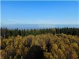
Polhograjska Grmada is an 898 m high peak located in the heart of the Polhograjski Dolomiti. The summit, which has a registration box with a stam...
2 h 10 min |
 | Dvor - Polhograjska Grmada (via Mala Grmada)
Polhograjska Grmada is an 898 m high peak located in the heart of the Polhograjski Dolomiti. The summit, which has a registration box with a stam...
1 h 45 min |
 | Gabrje - Polhograjska Grmada
Polhograjska Grmada is an 898 m high peak located in the heart of the Polhograjski Dolomiti. The summit, which has a registration box with a stam...
2 h 20 min |
 | Dvor - Polhograjska Grmada
Polhograjska Grmada is an 898 m high peak located in the heart of the Polhograjski Dolomiti. The summit, which has a registration box with a stam...
1 h 45 min |
 | Povodje - Šmarna gora (via Sedlo)
Šmarna gora is a 669 m high peak located north-west of the capital of Slovenia. The summit, which has a restaurant and a church, offers a beautif...
1 h 35 min |
 | Povodje - Šmarna gora (Partizanska steza)
Šmarna gora is a 669 m high peak located north-west of the capital of Slovenia. The summit, which has a restaurant and a church, offers a beautif...
1 h 45 min |
| Skaručna - Šmarna gora (Partizanska steza)
Šmarna gora is a 669 m high peak located north-west of the capital of Slovenia. The summit, which has a restaurant and a church, offers a beautif...
1 h 45 min |
 | Vikrče - Šmarna gora (Mazijeva steza)
Šmarna gora is a 669 m high peak located north-west of the capital of Slovenia. The summit, which has a restaurant and a church, offers a beautif...
1 h 35 min |
 | Preska - Sveti Jakob
The Church of St James is located on a hill north of the village of Topol near Medvode. From the top, where there is a registration box with a st...
1 h 45 min |
| Sora - Sveti Jakob
The Church of St James is located on a hill north of the village of Topol near Medvode. From the top, where there is a registration box with a st...
1 h 45 min |
 | Phliški bajer - Rašica (Vrh Staneta Kosca) (ridge path)
Vrh Staneta Kosca, better known as Rašica, is located north of Ljubljana, specifically above the village of Rašica and Dobena. From the top of th...
2 h |
| Topole - Rašica (Vrh Staneta Kosca) (ridge path)
Vrh Staneta Kosca, better known as Rašica, is located north of Ljubljana, specifically above the village of Rašica and Dobena. From the top of th...
2 h 10 min |
 | Pirman - Kurešček
Kurešček is an 826 m high peak located south of Ig and south-west of Želimlje. The view from the top, on which the church stands, is not possible...
1 h 45 min |
| Želimlje - Kurešček
Kurešček is an 826 m high peak located south of Ig and south-west of Želimlje. The view from the top, on which the church stands, is not possible...
1 h 50 min |
 | Sora - Osolnik (by road)
Osolnik is an 858 m high mountain located south of Škofja Loka and west of Medvode. From the top, where the Church of St. Mohor and Fortunatus st...
1 h 40 min |
 | Sora - Osolnik (via Hom)
Osolnik is an 858 m high mountain located south of Škofja Loka and west of Medvode. From the top, where the Church of St. Mohor and Fortunatus st...
1 h 50 min |
 | Puštal - Osolnik
Osolnik is an 858 m high mountain located south of Škofja Loka and west of Medvode. From the top, where the Church of St. Mohor and Fortunatus st...
2 h 15 min |
 | Sora - Osolnik (on footpath)
Osolnik is an 858 m high mountain located south of Škofja Loka and west of Medvode. From the top, where the Church of St. Mohor and Fortunatus st...
1 h 35 min |
| Puštal (Na Dobravi) - Osolnik
Osolnik is an 858 m high mountain located south of Škofja Loka and west of Medvode. From the top, where the Church of St. Mohor and Fortunatus st...
2 h |
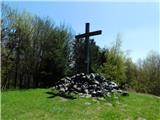
 | Preska - Jeterbenk (via Turnice)
Jeterbenk is a 774 m high peak located between Slavko's home at Gole Brdo and Katarina (Topol village). From the top, where there is a large cros...
2 h 15 min |
 | Preska - Jeterbenk (on ridge)
Jeterbenk is a 774 m high peak located between Slavko's home at Gole Brdo and Katarina (Topol village). From the top, where there is a large cros...
2 h 15 min |
 | Povodje - Grmada
Grmada is a 676 m high mountain located to the west of the much more visited Šmarna Gora. From the top, where there is a small airstrip, we have ...
1 h 50 min |
| Skaručna - Grmada
Grmada is a 676 m high mountain located to the west of the much more visited Šmarna Gora. From the top, where there is a small airstrip, we have ...
1 h 50 min |
 | Lake Gradišče - Limbarska gora
Limbarska gora is located north-east of Moravce. From the top there is a beautiful view of the surrounding peaks and in good weather you can also...
1 h 55 min |
 | Puštal (Na Dobravi) - Sveti Ožbolt (above Zminec)
Sveti Ožbolt is located on a scenic peak in the north of the Polhograjske Dolomites. It has a beautiful view of the Škofjeloško hribovje and part...
2 h 15 min |
 | Škofja Loka - Archangel Gabriel (Planica)
Planica is an 824 m high peak located north of Škofja Loka, between Krizna Gora and Planica. From the top, where the Church of St. Gabriel the Ar...
2 h 5 min |
 | Vrhnika-Tankovska cesta - Koča na Planini nad Vrhniko (Circular path Vrhnika-Planina-Lintvern-Vrhnika)
Planina above Vrhnika is for hers inhabitants something like Šmarna gora for inhabitants of Ljubljana. It is 733 metres high and is reachable fro...
2 h 20 min |
 | Kamnica - Sveti Miklavž above Sava (via Velika vas)
The Church of St Nicholas is situated on a hill south of Moravče. From the top you can enjoy a beautiful view of the nearby Limbarska gora, and t...
2 h 5 min |
 | Kamnica - Cicelj (via farm Buven)
Cicelj is a forested peak located between Moravče and the village of Senožeti. There is no view from the top, which has a bench and a registratio...
1 h 45 min |
 | Kamnica - Cicelj
Cicelj is a forested peak located between Moravče and the village of Senožeti. There is no view from the top, which has a bench and a registratio...
1 h 40 min |
 | Source of Hubelj - Navrše
Navrše is a little-known peak located southeast of the Otliška Window. From the top there is a beautiful view of the Vipava valley and the peaks ...
1 h 35 min |
 | Idrija - Hleviška planina (hunting path)
Hleviška planina (also Hleviška planina) is a slightly overgrown but still very scenic peak. From the top, which is the house mountain of Idrija,...
1 h 45 min |
 | Divje jezero - Hleviška planina (via Prižnica)
Hleviška planina (also Hleviška planina) is a slightly overgrown but still very scenic peak. From the top, which is the house mountain of Idrija,...
2 h 30 min |
 | Idrija - Hleviška planina (via Kodrov rovt)
Hleviška planina (also Hleviška planina) is a slightly overgrown but still very scenic peak. From the top, which is the house mountain of Idrija,...
2 h |
 | Stoperce - Donačka gora
Donačka gora is a peak located north of Rogatec. The peak, which geographically belongs to Karawanks, offers a beautiful view of the surrounding ...
2 h 5 min |
| Sveti Jurij - Donačka gora (western path)
Donačka gora is a peak located north of Rogatec. The peak, which geographically belongs to Karawanks, offers a beautiful view of the surrounding ...
1 h 35 min |
 | Polzela - Gora Oljka (via Vimperk)
Gora Oljka is a hill located east of Šmartno ob Paki. On the top stands the Church of the Holy Cross, which was built in the mid-18th century. Ju...
2 h 15 min |
| Podvin pri Polzeli - Gora Oljka (upper path)
Gora Oljka is a hill located east of Šmartno ob Paki. On the top stands the Church of the Holy Cross, which was built in the mid-18th century. Ju...
1 h 35 min |
 | Spodnja Rečica - Dom na Šmohorju (via Tolsto)
Dom na Šmohorju is located between Laško, Liboje and Zabukovica. From the house, or from the Church of St. Mohorj, a few minutes away, there is a...
1 h 35 min |
| Laško - Dom na Šmohorju
Dom na Šmohorju is located between Laško, Liboje and Zabukovica. From the house, or from the Church of St. Mohorj, a few minutes away, there is a...
2 h |
 | Gradišče - Gradiška Tura (via Plaz)
Gradiška Tura is a peak located on the western side of the Nanoška plateau. From the top, which is reached by a well-maintained climbing route an...
2 h |
 | Pedrovo - Trstelj
Trstelj is the highest peak in the Black Hills ridge. The view from the vast summit, where the TV transmitters stand, is split in half. From the ...
2 h |
 | Zamedveje - Korada
Korada is a scenic peak located to the west of the Soča River and to the north or on the northern edge of Goriško Brda. From the summit, which ha...
2 h 30 min |
 | Štore - Resevna
Resevna is a peak located south of Šentjur. On the top is a 20m high lookout tower, which gives us a beautiful view of almost the whole of Sloven...
2 h 30 min |
 | Zagrad - Tolsti vrh above Celjska koča (Po vrheh)
Tolsti, according to some records also Tovsto vrh, is located above the Celjska koča ski resort. The summit, which has a registration box and a s...
1 h 40 min |
 | Hayrack (Laška vas - Pečovje) - Tolsti vrh above Celjska koča (via chapel at Mary and on CPP)
Tolsti, according to some records also Tovsto vrh, is located above the Celjska koča ski resort. The summit, which has a registration box and a s...
1 h 35 min |
 | Zvodno - Tolsti vrh above Celjska koča (via Marija)
Tolsti, according to some records also Tovsto vrh, is located above the Celjska koča ski resort. The summit, which has a registration box and a s...
1 h 40 min |
 | Štore - Srebotnik (via Marija and south approach)
Srebotnik is a lightly vegetated peak located south of Celje and Štore in the Posavje Hills. From the top, which has a registration box and a sma...
1 h 45 min |
 | Teharje - Srebotnik (Pot I. Celjske čete)
Srebotnik is a lightly vegetated peak located south of Celje and Štore in the Posavje Hills. From the top, which has a registration box and a sma...
2 h |
 | Preska - Rog (via Turnice)
The Rog is a 798 m high peak located above the village of Topole, just 10 minutes from St Catherine's Church. From the top of the hill, where a l...
2 h 30 min |
| Preska - Rog (via Jeterbenk)
The Rog is a 798 m high peak located above the village of Topole, just 10 minutes from St Catherine's Church. From the top of the hill, where a l...
2 h 45 min |
 | Hrastnik - Klobuk (via Ravne)
Klobuk is a scenic peak located northeast of Hrastnik. The summit, which has a registration box and a stamp, offers a beautiful view of the valle...
2 h 25 min |
 | Bresternica (spodnji Rušnik) - Žavcarjev vrh
Žavcarjev vrh is a 915m high mountain located north of the River Drava on the slopes of Kozjak. As the peak is completely overgrown, there is no ...
1 h 40 min |
 | Kozjak nad Pesnico - Tojzlov vrh
Tojzlov vrh is a forested hill located in the eastern part of Kozjak. On the top of the hill stands a small stone monument to the National Libera...
2 h 5 min |
 | Gorjuša - Murovica (via Dobovlje)
Murovica is a popular excursion point, accessible from the Posavina side, Domžale or from the Moravška valley. There is a bench and a registratio...
2 h 40 min |
 | Senožeti - Murovica (via Vrh pri Dolskem)
Murovica is a popular excursion point, accessible from the Posavina side, Domžale or from the Moravška valley. There is a bench and a registratio...
2 h 5 min |
| Senožeti - Murovica (via farm Buven)
Murovica is a popular excursion point, accessible from the Posavina side, Domžale or from the Moravška valley. There is a bench and a registratio...
1 h 55 min |
 | Bistra - Mali Trebelnik
Mali Trebelnik is an 807 m high peak rising above the south-western part of the Ljubljana Marshes. Partly grassy and partly surrounded by forest,...
1 h 45 min |
 | Gabrje - Goljek
Goljek is an 809 m high peak located east of Polhograjska Grmada. The view from the summit, which is home to the remains of a former watchtower o...
1 h 40 min |
 | Cerkno - Veliki vrh (Lajše)
Veliki vrh is an almost 900 m high peak rising south of Cerkno. From the top, where there are several television and radio transmitters covering ...
2 h |
 | Izlake - Pleše (via Grobovščica)
Pleše is an 866 m high peak located between the Marela Ski Resort and Zasavska Sveta Gora. From the top, where the NOB monument is located, you h...
2 h 15 min |
 | Izlake - Pleše (via Vežnica)
Pleše is an 866 m high peak located between the Marela Ski Resort and Zasavska Sveta Gora. From the top, where the NOB monument is located, you h...
1 h 45 min |
 | Braslovško jezero - Grmada (Dobrovlje)
Grmada is an 898 m high forested peak located in the south-eastern part of the Dobrovlje plateau. The summit, on which the stamp is located, is n...
2 h 25 min |
| Letuš - Grmada (Dobrovlje)
Grmada is an 898 m high forested peak located in the south-eastern part of the Dobrovlje plateau. The summit, on which the stamp is located, is n...
2 h 25 min |
| Žovneško jezero - Grmada (Dobrovlje)
Grmada is an 898 m high forested peak located in the south-eastern part of the Dobrovlje plateau. The summit, on which the stamp is located, is n...
2 h 5 min |
 | Lesično - Oslica (Bohor)
Oslica is one of the peaks of Bohor. It is located in the eastern part of the mountain range. Unlike some of the higher peaks of Bohor, such as V...
1 h 45 min |
 | Kozje - Oslica (Bohor) (via Vetrnik)
Oslica is one of the peaks of Bohor. It is located in the eastern part of the mountain range. Unlike some of the higher peaks of Bohor, such as V...
2 h 10 min |
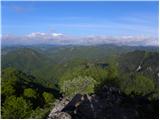
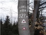 | Lesično - Debeli vrh (Bohor)
Debeli vrh is a 921-metre-high peak on Bohor between Veliki Koprivnik and Oslice. It is overgrown with dense forest, so there are no views. There...
1 h 45 min |
 | Kozje - Brest (Bohor) (via Vetrnik)
Brest is a peak on Bohor although it loks more like a saddle. It is an important intersection of the Bohor trails. It lies between Oslica, which ...
2 h |
| Tourist farm Žurej - Žusem (Panoramska pot - stara trasa)
Žusem is a 669-metre-high hill with a colourful history and great potential for the future. It represents the northern edge of the Kozjansko regi...
1 h 40 min |
 | Turistična kmetija Žurej - Žusem (Panoramska pot)
Žusem is a 669-metre-high hill with a colourful history and great potential for the future. It represents the northern edge of the Kozjansko regi...
1 h 40 min |
| Krka - Ciganov vrh (Korinjski hrib) (part of circular path Prijetno domače)
Ciganov vrh or Korinjski hill is a small hill rising above the valley of the river Krka, from which we have a view of the rather woded surroundin...
1 h 45 min |
 | Studenice - Plešivec (pri Boču)
Peace, silence, rugged terrain... the characteristics of a peak at the "crossroads" of many routes between the Maribor, Celje and Ptuj areas. Ple...
2 h |
 | Studenice - Plešivec (pri Boču) (final part on forest road)
Peace, silence, rugged terrain... the characteristics of a peak at the "crossroads" of many routes between the Maribor, Celje and Ptuj areas. Ple...
2 h |
 | Podvelka - Hlebov vrh (Rdeči Breg) (via Viltužnik)
The Red Bank stretches between the Radoljna Gorge in the east, the Drava River in the north and the Velka Stream in the east. It is separated fro...
2 h |
 | Puščava - Hlebov vrh (Rdeči Breg)
The Red Bank stretches between the Radoljna Gorge in the east, the Drava River in the north and the Velka Stream in the east. It is separated fro...
2 h 55 min |
| HE Ožbalt - Hlebov vrh (Rdeči Breg)
The Red Bank stretches between the Radoljna Gorge in the east, the Drava River in the north and the Velka Stream in the east. It is separated fro...
2 h 50 min |
 | Planinski dom Milana Šinkovca - Šenturška Gora
Šenturška Gora is a settlement located between the Tunji Hills and Krvavec. From the church, the village or the nearby agritourism, we have a bea...
2 h 15 min |
| Planinski dom Milana Šinkovca - Šenturška Gora (via Zaloški rob)
Šenturška Gora is a settlement located between the Tunji Hills and Krvavec. From the church, the village or the nearby agritourism, we have a bea...
2 h 15 min |
 | Brezno - Sveti Pankracij (Radelca) (by Remšniški potok)
The Church of St Pancras on Radelca is located on the border ridge between Slovenia and Austria, but since 1966, following an inter-state agreeme...
2 h 50 min |
 | Muta (Spodnja Muta) - Sveti Trije Kralji (above Radlje ob Dravi)
The Church of the Three Kings is situated on an 820-metre-high hill rising above the right bank of the Radlje Stream. The church offers a beautif...
2 h 30 min |
 | Dravograd (Meža) - Golarjev vrh
Golarjev vrh is an 843 m high forested peak located south to south-east of the Cvitrško saddle, between Otiški Vrh and Sveti Danijel....
1 h 50 min |
 | Zia - Dikeos (Kos)
Dikeos (846 m) is the highest mountain on the Kos island, the third-largest Dodecanese island in the southeastern Aegean sea in Greece (after Rho...
1 h 50 min |
 | Rechnitz (Badesee) - Irrotkő / Geschriebenstein
Irrotkő is the highest peak of the Kőszegi Hegység (Kőszegi Mountains) and also the highest peak in western Hungary and the Austrian state of Bur...
2 h 30 min |
 | Puščava - Klančnik (Glančnik)
Klančnik, also known as Glančnik on some maps, is an 877-metre-high peak located above the right bank of the Drava River, just a few minutes away...
2 h 15 min |
| HE Ožbalt - Klančnik (Glančnik)
Klančnik, also known as Glančnik on some maps, is an 877-metre-high peak located above the right bank of the Drava River, just a few minutes away...
2 h 10 min |
 | Podvelka - Klančnik (Glančnik) (via Sveti Ignacij)
Klančnik, also known as Glančnik on some maps, is an 877-metre-high peak located above the right bank of the Drava River, just a few minutes away...
2 h 30 min |
 | Brezno - Sveti Jurij (Remšnik) (along Remšniški potok)
The Church of St George is situated on a lookout point in the settlement Remšnik, which is on the slopes of Kozjak. Opposite the church, next to ...
1 h 35 min |
 | Rechnitz (Badesee) - Großer Hirschenstein
...
2 h |
 | Vuzenica - Sedovnikov vrh
...
2 h 35 min |