 | Molnarjev breg - Kamniški vrh
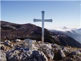
Kamniški vrh is a 1259 m high mountain located north of Kamnik, between Stahovica and the Korošica Valley. From the top of the peak there is a sm...
1 h 30 min |
| Molnarjev breg - Kamniški vrh (via planina Osredek)
Kamniški vrh is a 1259 m high mountain located north of Kamnik, between Stahovica and the Korošica Valley. From the top of the peak there is a sm...
1 h 30 min |
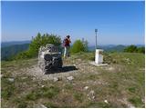
 | Predmeja - Kucelj na Čavnu (by road)
Kucelj is located on the southern slopes of Trnovo Forest, north-west of the Vipava valley. From the uncultivated summit on which the cross stand...
1 h 45 min |
 | Predmeja - Veliki Modrasovec (by road)
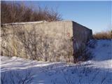
Veliki Modrasovec is located in the southern part of the Trnovo Forest near Predmeja. On the top of the hill is an old military building which yo...
1 h 20 min |
 | Mariborska koča - Žigartov vrh
At 1346m, Žigartov vrh is the highest peak in the eastern part of Pohorje. An "observation" tower used to stand on the summit, but was erected on...
1 h 40 min |
 | Uglov laz - Koča na Kamnem griču (via Dom na Travni Gori)
The cottage is located on Kamný hill, a scenic peak rising south-west of Sodražica. The grassy summit, surrounded by forest, offers a beautiful v...
2 h |
 | Koča na Šumiku - Klopni vrh (eastern path)
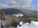
Klopni vrh encloses the lower lying extensive plateau in the eastern Pohorje Mountains from the north-west. The area of the horizontal section at...
2 h |
 | Koča na Šumiku - Klopni vrh (northern path)
Klopni vrh encloses the lower lying extensive plateau in the eastern Pohorje Mountains from the north-west. The area of the horizontal section at...
2 h |
 | Koča na Pesku - Klopni vrh
Klopni vrh encloses the lower lying extensive plateau in the eastern Pohorje Mountains from the north-west. The area of the horizontal section at...
2 h 5 min |
 | Dom na Čreti - Tolsti vrh (Dobrovlje)
Tolsti vrh is, together with Šentjoški vrh (1077m), the highest peak of the Dobrovelj Plateau. The view from the summit, which has a registration...
1 h 45 min |
 | Cenc - Špičasti vrh (on marked path)
Špičasti vrh is a forested mountain located south of the village of Zadlog. To ensure that the peak is not without a view, a 13m high wooden look...
1 h 30 min |
 | Zgornji Goreljek - Javorov vrh (Pokljuka)
Javorov vrh is a 1482 m high mountain located between the vast forests of Pokljuka, more precisely between mountain pasture Konjska dolina and mo...
1 h 30 min |
 | Strma Reber - Cerk
At 1192 m, Cerk is the highest peak of Borovška Gora, a mountain range located between the Kolpa River valley and Goteniškje Snežnik. From the to...
1 h 45 min |
 | Vojsko - Hudournik
Hudournik is a 1148 m high peak located on the northern edge of the Vojskar plateau, a plateau situated between the valleys of the Idrijca, Kanom...
1 h 30 min |
 | Livške Ravne - Na gradu
Na gradu is a 1115 m high peak located in the middle of the Kolovrat mountain range, on the border between Slovenia and Itali. The grassy peak, w...
1 h 25 min |
 | Cvetrež - Lašček (by road)
At 1071 m, Lašček is the highest peak of the Banjška plateau, a plateau rising above the Čepovan valley, the valley of the Soča River and the val...
1 h 20 min |
 | Gornje Jelenje - Tuhobić (mountain path on Tuhobić)
Tuhobić is a 1109-metre-high peak with a beautiful view on all sides, the most beautiful being Risnjak, Snježnik, Veliki Snežnik, Učka, Bjelolasi...
1 h 50 min |