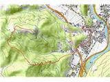
 | Deutschfeistritz - Schartnerkogel (via Gamskogel)
Schartnerkogel is a 931m high hill above the town of Deutschfeistritz (German Bistritz) in the western part of the Graz mountain range. A cross s...
3 h |
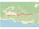
 | Hotovlja - Sivka (via Pasja ravan)
Sivka is a grassy peak located in the westernmost part of the Polhograje Hills. In good weather, the peak offers a magnificent view from Snežnik ...
3 h |
 | Nakovana - Sveti Ilija (Pelješac)
Sv. Ilija, also known as Zmija's Bumblebee, is a 961-metre-high mountain and the highest peak on the Pelješac peninsula. From the top, you can en...
2 h 45 min |
 | Ožbalt - Sršenov vrh
Sršenov vrh is a 963-metre-high peak located in the Kozjak Mountains, specifically between Ožbalt and Zgornja Kapla. The peak itself does not off...
2 h 45 min |
 | Podgora - Stene svete Ane (via Grmada)
Stene svete Ane is a vegetated peak located near the mountain hut at Sveti Anna on Mali gora. A small observation tower stands on the summit, whi...
3 h 40 min |
 | Lesično - Koprivnik (Bohor)
Koprivnik or Veliki Koprivnik is one of the many peaks in Bohor. It is located between Koča na Bohorju and Veliki Koprivnik. From the top of the ...
3 h 15 min |
 | Kozje - Koprivnik (Bohor) (via Vetrnik)
Koprivnik or Veliki Koprivnik is one of the many peaks in Bohor. It is located between Koča na Bohorju and Veliki Koprivnik. From the top of the ...
3 h 10 min |
 | Hunting cottage Budanje - Sinji vrh (eastern path via Škraplje)
Sinji vrh is a scenic mountain located between Col, Ajdovščina and Predmeja. From the top, you can enjoy a beautiful view over most of western Sl...
3 h 10 min |
| Hunting cottage Budanje - Sinji vrh (west path)
Sinji vrh is a scenic mountain located between Col, Ajdovščina and Predmeja. From the top, you can enjoy a beautiful view over most of western Sl...
3 h |
| Jamce - Sinji vrh (eastern path via Škraplje)
Sinji vrh is a scenic mountain located between Col, Ajdovščina and Predmeja. From the top, you can enjoy a beautiful view over most of western Sl...
2 h 55 min |
 | Cerkno - Štor (via Planina pri Cerknem)
Štor is a 1005 m high peak located directly above the Ermanovec Cottage. The peak itself is covered with forest, but from the meadow, which is on...
2 h 45 min |
 | Žička kartuzija - Stolpnik (via Skala and Krniški rob)
At 1012 m, Stolpnik is the highest peak of the Konjiška Gora, a mountain range stretching south-west from Slovenske Konjice. A 25 m high lookout ...
3 h 15 min |
 | Žička kartuzija - Stolpnik (Žička kartuzija - Stolpnik - Črešnjice)
At 1012 m, Stolpnik is the highest peak of the Konjiška Gora, a mountain range stretching south-west from Slovenske Konjice. A 25 m high lookout ...
3 h 15 min |
 | Matrafüred - Kékestető (red path via Peresberc in Negyeshatar)
Matra is a mountain range located 70 km east of Budapest. The two highest peaks in Hungary are Kékestető, which is the highest peak in Hungary at...
2 h 45 min |
 | Radlje ob Dravi - Bricnik (via Zavetišče Onuk - Glavar)
Bricnik is a 1017-metre-high peak located in the Kozjak Mountains, above Muta. On the top, which is covered by forest, there is a registration bo...
2 h 55 min |
 | Gabrje - Tošč
Tošč, which became the highest peak of Polhograjsko hribovje decades ago when Pasja ravan was lowered by 9 m by the Yugoslav army, is located nor...
3 h 5 min |
 | Kozje - Veliki Javornik (Bohor) (via Koprivnik)
Veliki Javornik is the highest peak of Bohor at 1023m. Although the peak is unspoilt and there are no higher hills far around, there is no view f...
2 h 45 min |
 | Poljane nad Škofjo Loko - Lubnik (via Gabrška gora)
Lubnik is a 1025 m high mountain rising steeply to the west of Škofja Loka. From the summit, on which the mountain lodge stands, you can enjoy a ...
3 h 45 min |
 | Cerkno - Ermanovec (via Kladje)
Ermanovec is a 1026 m high peak located between Cerkno and Gorenjska vasja, specifically above Sovodnje and Trebija. Just a few steps away from t...
2 h 55 min |
| Cerkno - Ermanovec (via Planina pri Cerknem)
Ermanovec is a 1026 m high peak located between Cerkno and Gorenjska vasja, specifically above Sovodnje and Trebija. Just a few steps away from t...
3 h |
 | Matavun - Vremščica
Vremščica is a mountain chain, stretching between Senožeče, Pivka and Divača. The highest top is also called Vremščica and the view from it is am...
3 h 15 min |
 | Cerkno - Bevkov vrh
Bevkov vrh, which is a point on the Slovenian mountain trail, is located between Cerkno and Spodnja Idrija. The summit is covered with forest and...
2 h 50 min |
| Straža - Želin - Bevkov vrh
Bevkov vrh, which is a point on the Slovenian mountain trail, is located between Cerkno and Spodnja Idrija. The summit is covered with forest and...
2 h 45 min |
 | Brezno - Kapunar / Kapunerkogel (along Remšniški potok)
Kapunar is a 1051 m high peak above Radlje ob Dravi. Just below the peak is an old caravan and border guardhouse, which is now used by radio amat...
3 h 35 min |
 | Kokarje (ŠRC Laze) - Tolsti vrh (Dobrovlje) (via Dom na Farbanci)
Tolsti vrh is, together with Šentjoški vrh (1077m), the highest peak of the Dobrovelj Plateau. The view from the summit, which has a registration...
3 h 15 min |
| Potok (Mostni graben) - Tolsti vrh (Dobrovlje) (via Dom na Farbanci)
Tolsti vrh is, together with Šentjoški vrh (1077m), the highest peak of the Dobrovelj Plateau. The view from the summit, which has a registration...
2 h 50 min |
 | Straža - Vrhovec
Vrhovec 1079 m (also Lokvarski vrh) high grassy peak located south of the Šebrelje plateau. From the top, where there is a panoramic signboard, y...
3 h 30 min |
 | Spodnja Rečica - Gozdnik (via Tolsto)
Gozdnik is a hill rising steeply above the village of Zabukovica. There is no view from the top, due to the forest, but there is a bivouac on it,...
3 h 20 min |
 | Hrastnik - Mrzlica (via Klobuk)
Mrzlica has become an extremely popular excursion point in the last few years, especially for visitors from the Savinjska Valley and Zasavje. At ...
3 h |
| Hrastnik - Mrzlica (via Ravne)
Mrzlica has become an extremely popular excursion point in the last few years, especially for visitors from the Savinjska Valley and Zasavje. At ...
3 h |
 | Log - Mariborski razglednik (Cigelnica)
Mariborski razglednik) is a 1147 m high peak located next to the Maribor Pohorje ski resort. A lookout tower stands at the top, offering a beauti...
2 h 50 min |
| Fram - Mariborski razglednik (Cigelnica) (via Petkovo sedlo)
Mariborski razglednik) is a 1147 m high peak located next to the Maribor Pohorje ski resort. A lookout tower stands at the top, offering a beauti...
3 h 25 min |
 | Srednja Kanomlja - Hudournik
Hudournik is a 1148 m high peak located on the northern edge of the Vojskar plateau, a plateau situated between the valleys of the Idrijca, Kanom...
3 h 45 min |
 | Pivola (Reka) - Ledinekov kogel (zahodna pot)
Ledinekov kogel is a 1182 m high peak located north of Maribor hut. Just below the summit is a fenced area with a radar tower....
2 h 45 min |
 | Fram - Ledinekov kogel (čez Petkovo sedlo, vzhodna pot)
Ledinekov kogel is a 1182 m high peak located north of Maribor hut. Just below the summit is a fenced area with a radar tower....
3 h 25 min |
| Fram - Ledinekov kogel (čez Petkovo sedlo, zahodna pot)
Ledinekov kogel is a 1182 m high peak located north of Maribor hut. Just below the summit is a fenced area with a radar tower....
3 h 30 min |
 | Osilnica - Cerk
At 1192 m, Cerk is the highest peak of Borovška Gora, a mountain range located between the Kolpa River valley and Goteniškje Snežnik. From the to...
4 h 5 min |
 | Loke - Črni vrh (Čemšeniška planina) (via Zajčeva koča)
Črni vrh is the highest peak of Čemšeniška mountain pasture and with a height of 1204 m it is the second highest peak in the Posavje - Zasavje hi...
3 h 35 min |
| Trbovlje - Črni vrh (Čemšeniška planina)
Črni vrh is the highest peak of Čemšeniška mountain pasture and with a height of 1204 m it is the second highest peak in the Posavje - Zasavje hi...
4 h |
 | Izlake - Črni vrh (Čemšeniška planina)
Črni vrh is the highest peak of Čemšeniška mountain pasture and with a height of 1204 m it is the second highest peak in the Posavje - Zasavje hi...
3 h |
 | Trbovlje - Kum (via Čebulova dolina)
At 1220 metres, Kum is the highest peak of Posavsko hribovje. Because it rises above Zasavje, some people call it the Zasavje Triglav. On the sum...
3 h 30 min |
 | Kamnje - Kucelj na Čavnu
Kucelj is located on the southern slopes of Trnovo Forest, north-west of the Vipava valley. From the uncultivated summit on which the cross stand...
2 h 45 min |
 | Stomaž - Kucelj na Čavnu
Kucelj is located on the southern slopes of Trnovo Forest, north-west of the Vipava valley. From the uncultivated summit on which the cross stand...
3 h |
 | Vrtovin - Kucelj na Čavnu (via Koča na Mali gori)
Kucelj is located on the southern slopes of Trnovo Forest, north-west of the Vipava valley. From the uncultivated summit on which the cross stand...
3 h |
 | Vitovlje - Veliki Rob
Veliki Rob is a scenic peak located between Kuclje (1237m) and Čavno (1185m). From the summit on which the cross is located, there is a beautiful...
3 h |
 | Vrtovin - Veliki Rob
Veliki Rob is a scenic peak located between Kuclje (1237m) and Čavno (1185m). From the summit on which the cross is located, there is a beautiful...
2 h 50 min |
| Vitovlje - Veliki Rob (via Vitovlje Lake and over Sekulak)
Veliki Rob is a scenic peak located between Kuclje (1237m) and Čavno (1185m). From the summit on which the cross is located, there is a beautiful...
3 h 10 min |
 | Lozice - Vojkova koča na Nanosu
Vojkova koča is located on the southern edge of the Nanoše plateau, close to Pleše, a peak that is clearly visible from the motorway. From the hu...
2 h 45 min |
| Gradišče - Vojkova koča na Nanosu (via Sveti Miklavž)
Vojkova koča is located on the southern edge of the Nanoše plateau, close to Pleše, a peak that is clearly visible from the motorway. From the hu...
3 h 45 min |
 | Reka - Kojca
Kojca is a scenic peak rising south of Baška Grape. The hay pile on the top offers a beautiful view of the Lower Bohinj Mountains, the Škofjelošk...
3 h 55 min |
 | Lozice - Suhi vrh (Nanos) (gentle path)
At 1313m, Suhi vrh is the highest peak of the karst plateau of Nanos. From the summit, which has a registration box and a stamp (the stamp is cur...
4 h 25 min |
 | Lozice - Suhi vrh (Nanos) (steep path)
At 1313m, Suhi vrh is the highest peak of the karst plateau of Nanos. From the summit, which has a registration box and a stamp (the stamp is cur...
4 h 10 min |
 | Činžat - Klopni vrh (northern path)
Klopni vrh encloses the lower lying extensive plateau in the eastern Pohorje Mountains from the north-west. The area of the horizontal section at...
2 h 45 min |
| Činžat - Klopni vrh (eastern path)
Klopni vrh encloses the lower lying extensive plateau in the eastern Pohorje Mountains from the north-west. The area of the horizontal section at...
2 h 45 min |
| Lovrenc na Pohorju - Klopni vrh (via Spodnji trg and on northern path)
Klopni vrh encloses the lower lying extensive plateau in the eastern Pohorje Mountains from the north-west. The area of the horizontal section at...
3 h 5 min |
| Lovrenc na Pohorju - Klopni vrh (via Spodnji trg and on eastern path)
Klopni vrh encloses the lower lying extensive plateau in the eastern Pohorje Mountains from the north-west. The area of the horizontal section at...
3 h 5 min |
| Ruše - Klopni vrh (severna pot)
Klopni vrh encloses the lower lying extensive plateau in the eastern Pohorje Mountains from the north-west. The area of the horizontal section at...
3 h 40 min |
| Ruše - Klopni vrh (vzhodna pot)
Klopni vrh encloses the lower lying extensive plateau in the eastern Pohorje Mountains from the north-west. The area of the horizontal section at...
3 h 55 min |
 | Oplotnica - Veliki vrh (on Pohorje)
Veliki vrh is a 1344-metre-high peak located above the RTC Jakec - Trije kralji ski resort. The highest point of the peak is located in the fores...
3 h 15 min |
| Zgornja Bistrica (Center Vintgar) - Veliki vrh (on Pohorje) (via Veliko Tinje)
Veliki vrh is a 1344-metre-high peak located above the RTC Jakec - Trije kralji ski resort. The highest point of the peak is located in the fores...
3 h 50 min |
| Zgornja Bistrica (Center Vintgar) - Veliki vrh (on Pohorje) (via Bistriški vintgar)
Veliki vrh is a 1344-metre-high peak located above the RTC Jakec - Trije kralji ski resort. The highest point of the peak is located in the fores...
3 h 45 min |
 | Ruše - Žigartov vrh
At 1346m, Žigartov vrh is the highest peak in the eastern part of Pohorje. An "observation" tower used to stand on the summit, but was erected on...
3 h 15 min |
 | Fram - Žigartov vrh
At 1346m, Žigartov vrh is the highest peak in the eastern part of Pohorje. An "observation" tower used to stand on the summit, but was erected on...
4 h 30 min |
| Log - Žigartov vrh
At 1346m, Žigartov vrh is the highest peak in the eastern part of Pohorje. An "observation" tower used to stand on the summit, but was erected on...
3 h 35 min |
| Pivola (Reka) - Žigartov vrh (via Petkovo sedlo)
At 1346m, Žigartov vrh is the highest peak in the eastern part of Pohorje. An "observation" tower used to stand on the summit, but was erected on...
3 h 55 min |
 | Kamnje - Veliki Modrasovec
Veliki Modrasovec is located in the southern part of the Trnovo Forest near Predmeja. On the top of the hill is an old military building which yo...
2 h 50 min |
| Vrtovin - Veliki Modrasovec
Veliki Modrasovec is located in the southern part of the Trnovo Forest near Predmeja. On the top of the hill is an old military building which yo...
3 h 5 min |
 | Bistriški jarek (Glasbeni dom) - Kozji vrh (at Košenjak)
Kozji vrh is a 1383-metre-high peak located above Pernice, and its height makes it the highest peak in the municipality of Muta....
2 h 45 min |