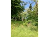
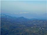
 | Krajiška Kutinica - Humka (Moslavačka gora)
Humka is the highest peak of Moslavačka Mountain, a mountain range located in the heart of Pannonian Croatia. Despite its relatively low altitude...
50 min |
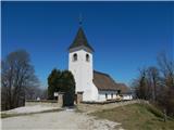
 | Štore - Turn (Sv. Janez Krstnik) (via Kompole)
Turn is a peak above Štorá - Šentjanž nad Štorami. Slightly below the summit, on the site of the former Prežin Castle, the Church of St. John the...
1 h 15 min |
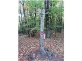 | Hunting cottage Muljava - Mali Petrovac (Petrova gora) (via Mali Velebit)
Mali Petrovac is a rather low hill located somewhere on the border between Banja and Kordun, Pannonian Croatia and Gorski Kotar. The top is compl...
1 h 15 min |
 | Gojače - Školj Svetega Pavla above Vrtovin (past trough)
The St Paul's Collegium is located on a lookout above the village of Vrtovin, west of Ajdovščina. From the church, near which the registration bo...
1 h |
| Malovše - Školj Svetega Pavla above Vrtovin
The St Paul's Collegium is located on a lookout above the village of Vrtovin, west of Ajdovščina. From the church, near which the registration bo...
1 h 5 min |
| Bistrica ob Sotli - Svete gore (Evropska pešpot E7 iz Bistrice ob Sotli)
Svete gore is a 527 m high hill in the Orlice mountain range, located in the easternmost part of the Posavje hills. The top of the hill, on which...
50 min |
 | Tremerje - Vipota
Vipota is a 532-metre-high peak south of Celje, above the left bank of the Savinja. Approaches to the summit are possible from several directions...
1 h |
 | Zagrad - Vipota
Vipota is a 532-metre-high peak south of Celje, above the left bank of the Savinja. Approaches to the summit are possible from several directions...
1 h |
 | Zagrad - Vipota (via crossing Ivankovič)
Vipota is a 532-metre-high peak south of Celje, above the left bank of the Savinja. Approaches to the summit are possible from several directions...
1 h 15 min |
 | Naraplje - Church of St. Bolfenk (Jelovice)
The Church of St. Bolfenko is situated on a 537-metre-high hill above Jelovice. From the top, you can enjoy a beautiful view of the Haloze and Bo...
1 h |
| Stogovci (Vabča vas) - Church of St. Bolfenk (Jelovice)
The Church of St. Bolfenko is situated on a 537-metre-high hill above Jelovice. From the top, you can enjoy a beautiful view of the Haloze and Bo...
1 h |
 | Zagorica pri Dobrniču - Lisec (Liška gora)
Lisec is a 565 m high peak located north to north-east of Žužemberk and south-west of Dobrnice. On the top of the peak stands a metal cross, to w...
1 h |
 | Podčetrtek (Terme Olimia) - Zavetišče Šmarnica na Mali Rudnici (mimo gradu Podčetrtek)
...
1 h 15 min |
| Podčetrtek (sveti Lovrenc) - Zavetišče Šmarnica na Mali Rudnici (mimo gradu Podčetrtek)
...
1 h 5 min |
| Podčetrtek (sveti Lovrenc) - Zavetišče Šmarnica na Mali Rudnici
...
1 h |
 | Tremerje - Veliki Slomnik
Veliki Slomnik is a peak located between Košnica pri Celju and Liboje. There is no view from the summit, which has a registration box, due to the...
1 h |
 | Podčetrtek (sveti Lovrenc) - Silavec (Stolp zdravja in veselja na Rudnici) (lažja pot)
...
1 h 15 min |
| Podčetrtek (sveti Lovrenc) - Silavec (Stolp zdravja in veselja na Rudnici) (težja pot)
...
1 h 15 min |
 | Zvodno - Bavč (via Suhi potok)
Bavč is a vegetated peak located south of Celje and Zvodno in Posavsko hribovje between Grmada and Srebotnik. On the way to the summit, we often ...
1 h 10 min |
 | Zvodno - Grmada above Celje (via Suhi potok)
What Šmarna Gora is to the inhabitants of Ljubljana, Grmada is to the inhabitants of Celjá. The hut mountain of Celje is located south of the tow...
1 h 15 min |