 | Potoče - Javorov vrh (via Sveti Jakob, below Potoška gora and over Baba)
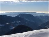
Javorov vrh (also Javorjev vrh according to some records) is a 1434 m high mountain located northeast of Preddvor. From the top, which has a regi...
2 h 55 min |
| Spodnja Kokra - Javorov vrh (via Baba)
Javorov vrh (also Javorjev vrh according to some records) is a 1434 m high mountain located northeast of Preddvor. From the top, which has a regi...
2 h 30 min |
 | Selski most - Babji zob
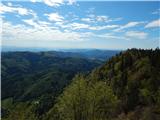
Babji zob is a lookout point above the village of Kupljenik near Bled. The precipitous peak, which has a registration box, has a beautiful view o...
2 h 30 min |
 | Bohinjska Bistrica - Krevl (on ski track)
Krevl is a 1515 m high peak located to the south of the Kobla ski area, more precisely between Koble Peak and Kravje Črna Gora. From the summit, ...
2 h 45 min |
 | Vitovlje - Čaven
Čaven is a forested peak located west of Veliki Rob (1237m). The peak, which has a very well-known name, is not reached by any marked trail, alth...
2 h 30 min |
| Vitovlje - Čaven (via Vitovlje Lake)
Čaven is a forested peak located west of Veliki Rob (1237m). The peak, which has a very well-known name, is not reached by any marked trail, alth...
2 h 40 min |
 | Jesenice (Straža) - Španov vrh (via Jelenkamen)
Španov vrh is a 1334m high mountain located between Javorniški Rovt and Mountain pasture below Golica. From the top, reached by the cable car of ...
2 h 30 min |
 | Njivica - Bela peč (Podbliška gora)
Bela peč is located on the edge of Jelovica above the village of Podblica. From the top of the cliff we have a beautiful view of the village, the...
2 h 35 min |
 | Kropa (Slovenska peč) - Bela peč (Podbliška gora) (via tehnika Meta)
Bela peč is located on the edge of Jelovica above the village of Podblica. From the top of the cliff we have a beautiful view of the village, the...
3 h |
| Kropa - Bela peč (Podbliška gora) (via tehnika Meta)
Bela peč is located on the edge of Jelovica above the village of Podblica. From the top of the cliff we have a beautiful view of the village, the...
3 h |
 | Libeliče - Šteharski vrh (Šteharnikov vrh) (via Trotov križ)
Šteharski or Šteharnikov vrh, also Črneška gora, is a 1018-metre-high mountain located in the south-eastern part of Strojna, a mountain range bet...
3 h |
 | Leše - Hom (above Prevalje) (via Kot pri Prevaljah)
Hom is a 1193 m high peak located between Uršlja gora and Prevalje. On the top there is a registration box with a registration book, but the view...
2 h 40 min |
| Prevalje - Hom (above Prevalje)
Hom is a 1193 m high peak located between Uršlja gora and Prevalje. On the top there is a registration box with a registration book, but the view...
3 h |
 | Mežica - Veliki vrh (above Mežiška dolina) (via Pikov vrh)
Veliki vrh is a 1165-metre-high peak located between Mežica and Črna na Koroškem. On the summit, there is a registration box with a registration ...
2 h 40 min |
 | Mežica - Šumahov vrh (via Pikov and Veliki vrh)
Šumahov vrh is a 1155-metre-high peak on which a wooden cross is erected. From the top, which descends steeply towards Žerjav, we have a beautifu...
3 h 5 min |
 | Ravne na Koroškem - Pokeržnikov vrh (via Šteharski vrh)
Pokeržnikov vrh is a 1,055-metre-high peak located above the village of Strojna in the municipality of Ravne na Koroškem. From the top, where the...
3 h 15 min |
 | Tržič - Robič (via Kamnek and Zavetišče na Kalu)
Robič is a 1384 m high peak located between the valley of Tržiška Bistrica and the ridge of Košuta. The summit offers a beautiful view, especiall...
3 h 35 min |
| Tržič (Čegelše) - Robič (via Zavetišče na Kalu)
Robič is a 1384 m high peak located between the valley of Tržiška Bistrica and the ridge of Košuta. The summit offers a beautiful view, especiall...
2 h 55 min |
 | Bistrica v Rožu / Feistritz im Rosental - Rabenberg
Rabenberg is a 1465 m high peak located in the Singerberg / Singerberg ridge. The summit offers some views to the north-west, but the view is blo...
3 h 20 min |
 | Činžat - Lamprehtov vrh
Lamprehtov vrh is a 1230 m high peak on Pohorje, located north-east of Klopni vrh....
2 h 30 min |
 | Mixnitz (Parkirišče Bärenschützklamm) - Ranerwand
...
2 h 30 min |