 | Za koridorjem - Sabotin (direct way)
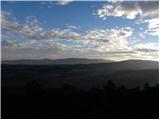
Sabotin is hill above Nova Gorica or more accurate above Solkan. Altough its low attitude it is great outlook with sight to Julian Alps, river So...
1 h |
 | Gojače - Školj Svetega Pavla above Vrtovin (past trough)
The St Paul's Collegium is located on a lookout above the village of Vrtovin, west of Ajdovščina. From the church, near which the registration bo...
1 h |
| Malovše - Školj Svetega Pavla above Vrtovin
The St Paul's Collegium is located on a lookout above the village of Vrtovin, west of Ajdovščina. From the church, near which the registration bo...
1 h 5 min |
 | Šešče pri Preboldu - Dragov dom na Homu (via Lajnarjev hrib)
Drago's home is located on a scenic hill, south of Šempeter. From the top, which is also the Church of St. Magdalene, there is a beautiful view f...
1 h |
 | Tremerje - Veliki Slomnik
Veliki Slomnik is a peak located between Košnica pri Celju and Liboje. There is no view from the summit, which has a registration box, due to the...
1 h |
 | Šentjur - Rifnik
Rifnik is a 568m high peak located south of Šentjur near Celje. The summit, which is famous for its archaeological site, offers a beautiful view ...
45 min |
 | Vezovje (bus station Vezovje most) - Rifnik
Rifnik is a 568m high peak located south of Šentjur near Celje. The summit, which is famous for its archaeological site, offers a beautiful view ...
45 min |
 | Ljubljana (Zalog) - Debenji vrh
Debenji vrh, also Debni or Deben vrh, is the highest peak of Kašeljski Hill, a small mountain range located between the valley of Besnica and the...
45 min |
 | Ljubljana (Zalog) - Debenji vrh
Debenji vrh, also Debni or Deben vrh, is the highest peak of Kašeljski Hill, a small mountain range located between the valley of Besnica and the...
45 min |
| Ljubljana (Zalog) - Debenji vrh (Trda varianta)
Debenji vrh, also Debni or Deben vrh, is the highest peak of Kašeljski Hill, a small mountain range located between the valley of Besnica and the...
40 min |
| Bistrica ob Sotli - Svete gore (E7 path from Bistrica ob Sotli)
Svete gore is a 527 m high hill in the Orlice mountain range, located in the easternmost part of the Posavje hills. The top of the hill, on which...
50 min |
 | Kubed - Lačna
Lačna is a 451 m high hill located between Gračišče, Kubed and Hrastovlje. The top of the hill has a metal lookout tower, which offers a beautifu...
45 min |
 | Trebnje Castle - Trebni vrh (steep path)
Trebni vrh is a 581-metre-high hill located south or south-west of Trebnje. On the top of the forested hill there is a bench, and near it there i...
45 min |
| Trebnje Castle - Trebni vrh (via caves)
Trebni vrh is a 581-metre-high hill located south or south-west of Trebnje. On the top of the forested hill there is a bench, and near it there i...
50 min |
 | Trebnje Castle - Trebni vrh (steep path via hunting cottage)
Trebni vrh is a 581-metre-high hill located south or south-west of Trebnje. On the top of the forested hill there is a bench, and near it there i...
55 min |
| Trebnje Castle - Trebni vrh (via caves and hunting lodge)
Trebni vrh is a 581-metre-high hill located south or south-west of Trebnje. On the top of the forested hill there is a bench, and near it there i...
1 h |
 | Zagorica pri Dobrniču - Lisec (Liška gora)
Lisec is a 565 m high peak located north to north-east of Žužemberk and south-west of Dobrnice. On the top of the peak stands a metal cross, to w...
1 h |
 | Tremerje - Vipota
Vipota is a 532-metre-high peak south of Celje, above the left bank of the Savinja. Approaches to the summit are possible from several directions...
1 h |
 | Zagrad - Vipota
Vipota is a 532-metre-high peak south of Celje, above the left bank of the Savinja. Approaches to the summit are possible from several directions...
1 h |
 | Zbelovo (railway underpass) - Ljubična gora (via Marijine stopinje)
Ljubična gora is a hill located above Ljubično, Zbelovo and Zbelovo Gora. The hill is hidden in the forest and is not very visible, but the churc...
45 min |
 | Zbelovo (railway underpass) - Ljubična gora
Ljubična gora is a hill located above Ljubično, Zbelovo and Zbelovo Gora. The hill is hidden in the forest and is not very visible, but the churc...
45 min |
 | Gradišče - Plaz
The Plaza or Plaza Peak is a 528-metre-high peak above the Vipava valley. More precisely between Vipava and Gradiste. From the top, where there i...
40 min |
 | Lovska koča Muljava - Mali Petrovac (Petrova gora) (Roman path)
Mali Petrovac is a rather low hill located somewhere on the border between Banja and Kordun, Pannonian Croatia and Gorski Kotar. The top is compl...
1 h |
 | Lovska koča Muljava - Veliki Petrovac (Petrova gora) (Roman path)
Veliki Petrovac is a 512-metre-high peak on Petrova Gora....
50 min |
 | Naraplje - Church of St. Bolfenk (Jelovice)
The Church of St. Bolfenko is situated on a 537-metre-high hill above Jelovice. From the top, you can enjoy a beautiful view of the Haloze and Bo...
1 h |
| Stogovci (Vabča vas) - Church of St. Bolfenk (Jelovice)
The Church of St. Bolfenko is situated on a 537-metre-high hill above Jelovice. From the top, you can enjoy a beautiful view of the Haloze and Bo...
1 h |
 | Podčetrtek (sveti Lovrenc) - Zavetišče Šmarnica on Mala Rudnica (past castle Podčetrtek)
...
1 h 5 min |
| Podčetrtek (sveti Lovrenc) - Zavetišče Šmarnica on Mala Rudnica
...
1 h |
 | Radeče - Svinjski rt
...
45 min |
 | Spodnje Radvanje - Archaeological site Poštela
...
40 min |
 | Prebold - Žvajga (northern peak) (eastern path)
...
50 min |
 | Prebold - Žvajga (northern peak) (western path)
...
1 h 5 min |
 | Liganj - Lužinski breg
...
1 h |
 | Jama Pekel (parkirišče) - Apno (krajša pot)
...
1 h |