 | Molnarjev breg - Kamniški vrh
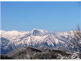
Kamniški vrh is a 1259 m high mountain located north of Kamnik, between Stahovica and the Korošica Valley. From the top of the peak there is a sm...
1 h 30 min |
| Molnarjev breg - Kamniški vrh (via planina Osredek)
Kamniški vrh is a 1259 m high mountain located north of Kamnik, between Stahovica and the Korošica Valley. From the top of the peak there is a sm...
1 h 30 min |
 | Črni Vrh - Pasja ravan
Pasja ravan is the second highest peak in the Polhograje Hills. A few decades ago, at 1029 m, it was the highest peak, but the Yugoslav army flat...
1 h |
 | Otlica - Sinji vrh
Sinji vrh is a scenic mountain located between Col, Ajdovščina and Predmeja. From the top, you can enjoy a beautiful view over most of western Sl...
1 h 20 min |
 | Vrbiški dol - Koča na Kozleku
The hut is located south-west of Ilirska Bistrica, just a few metres below the top of Kozlek. From the top, the view is only to the south and wes...
1 h |
 | Podlanišče - Ermanovec
Ermanovec is a 1026 m high peak located between Cerkno and Gorenjska vasja, specifically above Sovodnje and Trebija. Just a few steps away from t...
1 h 35 min |
 | Zagrad - Ostrič
Ostrič (also marked as Žabnik on some maps) is a 1056m high peak located on the Slovenian side of Čičárija. From the uncultivated summit, on whic...
1 h 5 min |
 | Vojsko - Hudournik
Hudournik is a 1148 m high peak located on the northern edge of the Vojskar plateau, a plateau situated between the valleys of the Idrijca, Kanom...
1 h 30 min |
 | Podlanišče - Štor
Štor is a 1005 m high peak located directly above the Ermanovec Cottage. The peak itself is covered with forest, but from the meadow, which is on...
1 h 20 min |
 | Podlanišče - Škofje
Škofje is a 973 m high peak located above the villages of Čeplez, Planina pri Cerknem and Podpleče. The peak itself, on which stands a small conc...
1 h 10 min |
 | Solarji - Deveti konfin (kota 930) (via Ježa)
Očna is a 906 m high peak located in the Kolovrat mountain range, west of Tolmina. From the meadow a few metres away from the summit, we have a b...
1 h 20 min |
 | Solarji - Deveti konfin (kota 942) (via Ježa)
Deveti konfin is a 930 m high peak in the Kolovrat mountain range, located between Ježa and Očno. There is no view from the summit, where a small...
1 h 10 min |
 | Cvetrež - Lašček
At 1071 m, Lašček is the highest peak of the Banjška plateau, a plateau rising above the Čepovan valley, the valley of the Soča River and the val...
1 h |
| Cvetrež - Lašček (by road)
At 1071 m, Lašček is the highest peak of the Banjška plateau, a plateau rising above the Čepovan valley, the valley of the Soča River and the val...
1 h 20 min |
 | Srednji Lokovec - Lašček (via Novo Mesto)
At 1071 m, Lašček is the highest peak of the Banjška plateau, a plateau rising above the Čepovan valley, the valley of the Soča River and the val...
1 h 45 min |
 | Bele Vode (Sveti Andrej) - Sveti Križ above Bele Vode (upper path)
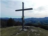
Sveti Križ is a scenic mountain located above Beli Voda. From the top, which is home to a number of church buildings and a conversion tower, we h...
1 h |
 | Koča pri Jelenovem studencu - Ledenik
At 1072 metres, Ledenik is the highest peak of Stojna, a forested ridge located between Kočevje and Kočevsko Rijeka. On the summit there is a reg...
1 h 15 min |
 | Gornje Jelenje - Tuhobić (mountain path on Tuhobić)
Tuhobić is a 1109-metre-high peak with a beautiful view on all sides, the most beautiful being Risnjak, Snježnik, Veliki Snežnik, Učka, Bjelolasi...
1 h 50 min |
 | Teichalm (Angerwirt) - Gschaidberg
...
1 h 50 min |
 | Slavica - Velika Slavica
...
1 h |
 | Omar - Kolevrat
...
1 h |