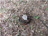
 | Rodik - Ajdovščina
Ajdovščina is an 804 metre high peak located above Rodik and Slopes. Today, a metal container stands on the vegetated summit, and the ruins of th...
40 min |
 | Pogorelec - Sedlata gorica (Pogorelec)
Sedlata gorica is a peak above the village Podturn near Dolenjske Toplice. The peak used to be overgrown, but nowadays there is a hill on the top...
45 min |
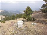
 | Gradec - Osojnica
Osojnica is a forested hill located west of Pivka. There is no view from the top, which has a registration box, a stamp and a bench....
45 min |
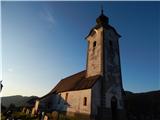
 | Podblica - Sveti Primož in Felicijan (Jamnik)
The Church of St. Primož and Felicijan on Jamnik, is situated on a scenic grassy ridge rising between Kropa and Podblica. From the church or its ...
50 min |
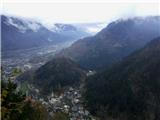
 | Podhom - Hom pri Bledu
Hom is an 834 m high hill that rises north above the villages Zasip and Podhom near Bled, or south of the village Blejska Dobrava near Jesenice. ...
40 min |
 | Koroška Bela - Malnež
Malnež is an 846 m high lookout peak of the southern Karavanke mountain range, located on the eastern side of the valley in which the village Kor...
40 min |
 | Kočna - Vrše (by ski slope)
The 850 m high hill Vrše, across which the TNP boundary runs, rises south-west above the village Blejska Dobrava, or east of the settlement Kočna...
45 min |
 | Kočna - Vrše (čez senožeti)
The 850 m high hill Vrše, across which the TNP boundary runs, rises south-west above the village Blejska Dobrava, or east of the settlement Kočna...
50 min |
 | Čepovan (Želinc) - Vrh Skopice
Vrh Skopice is a scenic peak located between the Čepovan valley, the Idrijca valley and the Trebuščice valley. From the top, where there is a reg...
50 min |
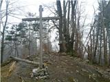
 | Lohača - Petričev hrib
Petričev hrib is the peak north of Postojna and west of Mountain pasture. From the summit, which has a registration box, there is a beautiful vie...
40 min |
 | Gozd - Vovar (Pot razgleda)
An obscure hill in front of the Kamnik mountains. Recently covered by storms, it has been covered with wood harvesting tracks.There is also a sma...
45 min |
| Gozd - Vovar (eastern path)
An obscure hill in front of the Kamnik mountains. Recently covered by storms, it has been covered with wood harvesting tracks.There is also a sma...
45 min |
| Gozd - Vovar (northern path)
An obscure hill in front of the Kamnik mountains. Recently covered by storms, it has been covered with wood harvesting tracks.There is also a sma...
45 min |
 | Koprivna (Šumel) - Sveti Jakob in Koprivna
The Church of St James in Koprivna is situated on a lookout hill above the right bank of the Mež River. The church offers a beautiful view of Rad...
50 min |
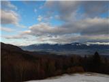
 | Kamenščina - Velika Milanja
Velika Milanja is a 1099m high peak located to the east of Volovje Ribri. From the partially uncultivated summit, we have a beautiful view of the...
40 min |
 | Zatrnik - Hotunjski vrh (west path)
Hotunjski vrh is a 1107-metre-high lookout peak located above the Zatrnik ski resort. From the top, where there is a registration box and a bench...
40 min |
| Zatrnik - Hotunjski vrh (north path)
Hotunjski vrh is a 1107-metre-high lookout peak located above the Zatrnik ski resort. From the top, where there is a registration box and a bench...
40 min |
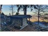
 | Planinski dom Vrhe - Javor
Javor is a 1132 m high peak located between Kisovec and Sveta mountain pasture. There is no view from the top, which is covered with forest, but ...
35 min |
 | Rekarjev rovt - Police
Some of the many peaks of the Mežakla plateau, which belongs to Julian Alps, are interesting as lookout points. One of them is certainly the peak...
45 min |