 | Mangartsko sedlo - Mangart (Italian way)
Mangart (also Mangrt, both spellings are grammatically correct) is a mountain that receives a very high number of visitors in summer. Access to t...
2 h |
 | Dom na Gospincu - Vrh Korena (via Zvoh)
Vrh Korena is located between Zvoh and Kalški greben near the Krvavški ski slopes. From the top there is a beautiful view towards the highest pea...
2 h 40 min |
| Kriška planina - Vrh Korena (via Zvoh)
Vrh Korena is located between Zvoh and Kalški greben near the Krvavški ski slopes. From the top there is a beautiful view towards the highest pea...
2 h 40 min |
 | Planina Pungrat - Veliko Kladivo
Veliko Kladivo is a 2094 m high peak in the Košuta Ridge, the longest Slovenian ridge. From the summit, which has a registration box and a stamp,...
2 h 15 min |
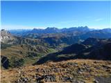
 | Podolševa (Rogar) - Govca (Olševa) (direct way)
Govca is the highest peak of the Olševa, a mountain range rising above Koprivna, Solčava and Remschenik (Remschenik / Remschenig is a valley on t...
2 h 10 min |
 | Podolševa (Sveti Duh, Strevc) - Govca (Olševa) (via Obel kamen)
Govca is the highest peak of the Olševa, a mountain range rising above Koprivna, Solčava and Remschenik (Remschenik / Remschenig is a valley on t...
2 h 30 min |
| Podolševa (Sveti Duh, Strevc) - Govca (Olševa)
Govca is the highest peak of the Olševa, a mountain range rising above Koprivna, Solčava and Remschenik (Remschenik / Remschenig is a valley on t...
2 h 15 min |
| Podolševa (Rogar) - Govca (Olševa) (via Obel kamen)
Govca is the highest peak of the Olševa, a mountain range rising above Koprivna, Solčava and Remschenik (Remschenik / Remschenig is a valley on t...
2 h 25 min |
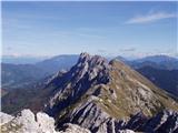
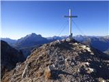
 | Passo Falzarego - Lagazuoi Piccolo (via gallery)
Lagazuoi Piccolo is a 2778m high mountain located north of the alpine pass of Pso Falzarego (2105m). From the top where the cross stands, we have...
2 h 15 min |
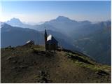 | Rifugio Valparola - Col di Lana (path 21)
Col di Lana also known in Italian as Col di Sangue (Blody Mountain), is a 2,452-metre-high mountain located to the west of the Valparola and Falz...
2 h 40 min |
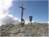
 | Passo Pordoi - Sas Ciapel
Sas Ciapel is a 2557 m high peak in the Padon Ridge. From the summit, where a small cross is erected, you can enjoy a very nice view of the nearb...
1 h 50 min |
 | Passo Giau - Monte Cernera
Monte Cernera is a 2665 m high peak located south of the Passo Giau Pass. The summit, on which the cross is erected, offers a very fine view over...
2 h |
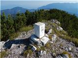 | Podolševa (Sveti Duh, Strevc) - Obel kamen (Olševa) (west path)
Obel kamen is a 1911 m high peak located in the Olševa Ridge. On the summit there is a boundary stone marked RS XXII 1, the cross and the registr...
2 h |
| Podolševa (Rogar) - Obel kamen (Olševa) (west path)
Obel kamen is a 1911 m high peak located in the Olševa Ridge. On the summit there is a boundary stone marked RS XXII 1, the cross and the registr...
1 h 55 min |
 | Podolševa (Sveti Duh, Strevc) - Obel kamen (Olševa) (east path)
Obel kamen is a 1911 m high peak located in the Olševa Ridge. On the summit there is a boundary stone marked RS XXII 1, the cross and the registr...
2 h 15 min |
| Podolševa (Rogar) - Obel kamen (Olševa) (east path)
Obel kamen is a 1911 m high peak located in the Olševa Ridge. On the summit there is a boundary stone marked RS XXII 1, the cross and the registr...
2 h 10 min |
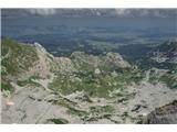 | Dolina Dobri do - Bobotov kuk
Bobotov kuk is the highest peak of Durmitor. It is the highest peak of the XXXXXX range. The southern approaches are the shortest and the eastern...
2 h 45 min |