 | Topol - Polhograjska Grmada
Polhograjska Grmada is an 898 m high peak located in the heart of the Polhograjski Dolomiti. The summit, which has a registration box with a stam...
1 h 15 min |
| Belo - Polhograjska Grmada
Polhograjska Grmada is an 898 m high peak located in the heart of the Polhograjski Dolomiti. The summit, which has a registration box with a stam...
1 h 20 min |
 | Trnovec - Polhograjska Grmada
Polhograjska Grmada is an 898 m high peak located in the heart of the Polhograjski Dolomiti. The summit, which has a registration box with a stam...
1 h 15 min |
 | Legastja - Sveti Jakob
The Church of St James is located on a hill north of the village of Topol near Medvode. From the top, where there is a registration box with a st...
1 h 10 min |
 | Legastja - Sveti Jakob (north path)
The Church of St James is located on a hill north of the village of Topol near Medvode. From the top, where there is a registration box with a st...
1 h |
 | Pševo - Sveti Jošt above Kranj (Sodarjeva pot, past the chapel)
Sveti Jošt above Kranj, is a hill located to the west of the slightly lower Šmarjetna Gora. From the top, where the Church of St. Jošto and the J...
50 min |
| Tičnica - Sveti Jošt above Kranj (Pot prijateljev Sv. Jošta, on stairs)
Sveti Jošt above Kranj, is a hill located to the west of the slightly lower Šmarjetna Gora. From the top, where the Church of St. Jošto and the J...
1 h 15 min |
| Tičnica - Sveti Jošt above Kranj (Pot prijateljev Sv. Jošta, na klopca)
Sveti Jošt above Kranj, is a hill located to the west of the slightly lower Šmarjetna Gora. From the top, where the Church of St. Jošto and the J...
1 h 15 min |
| Tičnica - Sveti Jošt above Kranj (Pot prijateljev Sv. Jošta, past the chapel)
Sveti Jošt above Kranj, is a hill located to the west of the slightly lower Šmarjetna Gora. From the top, where the Church of St. Jošto and the J...
1 h 20 min |
 | Slavkov dom na Golem brdu - Jeterbenk
Jeterbenk is a 774 m high peak located between Slavko's home at Gole Brdo and Katarina (Topol village). From the top, where there is a large cros...
1 h 15 min |
 | Žlebe - Jeterbenk (via Turnice)
Jeterbenk is a 774 m high peak located between Slavko's home at Gole Brdo and Katarina (Topol village). From the top, where there is a large cros...
1 h |
 | Žlebe - Jeterbenk (on ridge)
Jeterbenk is a 774 m high peak located between Slavko's home at Gole Brdo and Katarina (Topol village). From the top, where there is a large cros...
1 h 5 min |
 | Praproče - Polhograjska Gora (Sveti Lovrenc) (gentle path)
Polhograjska Gora, also just Gora or Sveti Lovrenc, is an 824 m high hill located north-west of Polhov Gradec. From the top of the hill, where th...
50 min |
 | Polhov Gradec (Blagajev grad) - Polhograjska Gora (Sveti Lovrenc)
Polhograjska Gora, also just Gora or Sveti Lovrenc, is an 824 m high hill located north-west of Polhov Gradec. From the top of the hill, where th...
1 h 5 min |
 | Polhov Gradec (Blagaj Castle) - Polhograjska Gora (Sveti Lovrenc) (via castle water catchment)
Polhograjska Gora, also just Gora or Sveti Lovrenc, is an 824 m high hill located north-west of Polhov Gradec. From the top of the hill, where th...
1 h 10 min |
| Polhov Gradec (Blagaj Castle) - Polhograjska Gora (Sveti Lovrenc) (by cart track)
Polhograjska Gora, also just Gora or Sveti Lovrenc, is an 824 m high hill located north-west of Polhov Gradec. From the top of the hill, where th...
1 h 15 min |
 | Vrzdenec - Kožljek
Kožljek is a 788 m high peak located to the west of Koreno, specifically above the village of Samotorica. From the top, where there are a few ben...
1 h 5 min |
 | Preval Prosca - Koreno (gentle path)
Koreno also Koreno is a 729 m high hill located north of Horjul. From the top, where there is a large cross, the Church of St. Mohorj and Fortuna...
1 h 15 min |
 | Preval Prosca - Koreno
Koreno also Koreno is a 729 m high hill located north of Horjul. From the top, where there is a large cross, the Church of St. Mohorj and Fortuna...
1 h |
 | Briše - Koreno
Koreno also Koreno is a 729 m high hill located north of Horjul. From the top, where there is a large cross, the Church of St. Mohorj and Fortuna...
50 min |
 | Potoki - Ajdna
Ajdna is a peak with a beautiful view of Hochstuhl, Jelovica, Pokljuka and the Julian Alps. Part of the Gornjesavska valley between Žirovnica and...
1 h |
 | Sv. Andrej - Sveti Ožbolt (above Zminec)
Sveti Ožbolt is located on a scenic peak in the north of the Polhograjske Dolomites. It has a beautiful view of the Škofjeloško hribovje and part...
1 h |
 | Loščica - Vremščica
Vremščica is a mountain chain, stretching between Senožeče, Pivka and Divača. The highest top is also called Vremščica and the view from it is am...
1 h 15 min |
 | Star maln - Koča na Planini nad Vrhniko
Planina above Vrhnika is for hers inhabitants something like Šmarna gora for inhabitants of Ljubljana. It is 733 metres high and is reachable fro...
1 h |
 | Kuren - Ulovka
Ulovka is the peak between Zaplana and the Shelter at Mountain pasture above Vrhnika. From the top, which is reached by ski lifts, there is a nic...
50 min |
 | Hotovlja - Bukov vrh (footpath)
Bukov vrh, on which the Church of the Sorrowful Mother of God stands, is located in the north-western part of the Polhograje hills. From the top ...
1 h |
 | Podgorje - Kojnik (steep path)
Kojnik is a partially vegetated peak located in the southern part of the Podgorje Karst near the Slovenian-Croatian border. From the top of the s...
1 h |
 | Zazid - Kojnik
Kojnik is a partially vegetated peak located in the southern part of the Podgorje Karst near the Slovenian-Croatian border. From the top of the s...
1 h 20 min |
 | Begunje - Velika Špička (via Cemarovnik)
Velika Špička or Špičasto Stražišče is a peak located north of Slivnica. From the top, which has a registration box with a stamp, there is a beau...
1 h |
 | Begunje - Velika Špička
Velika Špička or Špičasto Stražišče is a peak located north of Slivnica. From the top, which has a registration box with a stamp, there is a beau...
1 h |
 | Širje - Dom v Gorah
The mountain lodge in Gora is located east of Hrastnik, just a few metres below the 786m-high peak on which the Church of St George stands. From ...
1 h 20 min |
| Krnice - Dom v Gorah
The mountain lodge in Gora is located east of Hrastnik, just a few metres below the 786m-high peak on which the Church of St George stands. From ...
1 h 5 min |
 | Marno - Dom v Gorah
The mountain lodge in Gora is located east of Hrastnik, just a few metres below the 786m-high peak on which the Church of St George stands. From ...
1 h 15 min |
 | Studeno - Gora (Sveti Lovrenc)
Gora, or Sveti Lovrenc, is a peak above Studeni. It is a village north of Postojna, which is also a good starting point for climbing to the top o...
1 h 5 min |
 | Gorenje - Gora (Sveti Lovrenc)
Gora, or Sveti Lovrenc, is a peak above Studeni. It is a village north of Postojna, which is also a good starting point for climbing to the top o...
1 h 15 min |
 | Sovodenj - Bevkov vrh (steep way)
Bevkov vrh, which is a point on the Slovenian mountain trail, is located between Cerkno and Spodnja Idrija. The summit is covered with forest and...
1 h 15 min |
 | Dobrič - Gora Oljka
Gora Oljka is a hill located east of Šmartno ob Paki. On the top stands the Church of the Holy Cross, which was built in the mid-18th century. Ju...
50 min |
 | Dobrič (Vedet) - Gora Oljka (via Brezovec)
Gora Oljka is a hill located east of Šmartno ob Paki. On the top stands the Church of the Holy Cross, which was built in the mid-18th century. Ju...
50 min |
 | Matke - Golava
Golava is a peak located north of Mrzlica. From the summit, on which a small bivouac (Blaž's bivouac) stands, there is a beautiful view towards t...
1 h 15 min |
 | Zabukovica - Kotečnik
Kotečnik is a peak in Posavsko hribovje, located north of Šmohor. Kotečnik is a peak with two entry boxes. The first one is located on the wester...
1 h 15 min |
 | Žička kartuzija - Skala
Skala is a viewpoint on the eastern part of Konjiška Gora. From the viewpoint, which has a table, bench and a registration box, there is a beauti...
1 h |
 | Mrzle doline - Sveti Peter
Sveti Peter is a partially vegetated peak in the Dry Krajina above the village of Dvor. On the top there is a small shelter (usually open on Sund...
1 h 15 min |
 | Komarna vas - Gače
Gače is a popular excursion point for nature lovers and the only ski centre in Dolenjska (SC Bela), which offers pleasant skiing in winter and pl...
1 h |
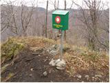
 | Legastja - Rog
The Rog is a 798 m high peak located above the village of Topole, just 10 minutes from St Catherine's Church. From the top of the hill, where a l...
1 h 15 min |
 | Tržič - Kamnek (Radetzky way)
Kamnek (Kamnik on maps, but also Kamnjek) is a scenic peak above Tržič....
1 h |
 | Tržič (Slap) - Kamnek (via Ride)
Kamnek (Kamnik on maps, but also Kamnjek) is a scenic peak above Tržič....
55 min |
 | Bločice - Križna gora
Križna gora is a partially overloked peak located above the village of Sveta Ana and Podlož. From the top of the hill on which the Church of the ...
1 h 15 min |
 | Veliko Trebeljevo - Obolno
Obolno is a 776m high peak located south-west of the village of the same name. The grassy summit, next to which the radio club hut stands, offers...
1 h 20 min |
 | Podgora - Kamen vrh
Kamen vrh is a scenic peak located on the northern outskirts of Mala Gora. From the top, surrounded by low bushes, there is a beautiful view of p...
1 h |
 | Podpeč - Kamen vrh
Kamen vrh is a scenic peak located on the northern outskirts of Mala Gora. From the top, surrounded by low bushes, there is a beautiful view of p...
50 min |
 | Podgora - Grmada on Mala gora
Grmada (also Grmada nad Ortnek) is an 887 m high peak located above the village of Vrh pri Poljanah in the Mala Gora mountain range. Just a few m...
1 h 20 min |
 | Ortnek - Grmada on Mala gora
Grmada (also Grmada nad Ortnek) is an 887 m high peak located above the village of Vrh pri Poljanah in the Mala Gora mountain range. Just a few m...
1 h |
 | Steljnik - Stene svete Ane
Stene svete Ane is a vegetated peak located near the mountain hut at Sveti Anna on Mali gora. A small observation tower stands on the summit, whi...
1 h 20 min |
| Seljan - Stene svete Ane (gentle path)
Stene svete Ane is a vegetated peak located near the mountain hut at Sveti Anna on Mali gora. A small observation tower stands on the summit, whi...
1 h 5 min |
 | Col - Kovk
Kovk is a scenic peak located to the west of Cola, on a jagged ridge rising steeply above the Vipava valley. From the top with a cross, we have a...
1 h |
 | Adergas - Štefanja gora (via benches)
Štefanja gora on which the Church of St Stephen stands, is located above Cerkly in Gorenjska. Just 10 metres below the summit, the Pr'Mežnarju ex...
1 h |
 | Adergas - Štefanja gora (via šterna)
Štefanja gora on which the Church of St Stephen stands, is located above Cerkly in Gorenjska. Just 10 metres below the summit, the Pr'Mežnarju ex...
1 h |
 | Olševek - Štefanja gora
Štefanja gora on which the Church of St Stephen stands, is located above Cerkly in Gorenjska. Just 10 metres below the summit, the Pr'Mežnarju ex...
55 min |
 | Velesovo - Štefanja gora (via benches)
Štefanja gora on which the Church of St Stephen stands, is located above Cerkly in Gorenjska. Just 10 metres below the summit, the Pr'Mežnarju ex...
1 h 10 min |
| Velesovo - Štefanja gora (via Šterna)
Štefanja gora on which the Church of St Stephen stands, is located above Cerkly in Gorenjska. Just 10 metres below the summit, the Pr'Mežnarju ex...
1 h 10 min |
 | Hotedršica - Medvedje Brdo
Medvedje Brdo is a small settlement located north of Hotedršice. The highest point of the village is a pleasant lookout point located on Šinkovco...
1 h 15 min |
 | Borovec pri Kočevski Reki - Krempa
Krempa is a 944 m high mountain located in the central part of the Borovška Mountains, a mountain range rising steeply above the Upper Kolpa Vall...
50 min |
 | Polhov Gradec (Božna) - Mala Grmada (via Setnica)
Mala Grmada is an 853 m high peak located south-west of the slightly higher Polhograjska Grmada. From the top, you have a beautiful view over the...
1 h 15 min |
 | Suhi Dol - Goli vrh (Uradna markirana pot)
Goli vrh, also known as Golni vrh on maps, is a nondescript forested peak located above the scattered settlement of Goli Vrh. There is no view fr...
1 h |
 | Ljubljanica - Sveti Andrej (Planina above Horjul)
The Church of St Andrew is situated on a lookout hill just above the Mountain pasture above Horjul. The church, which was built in 1659, offers a...
1 h 15 min |
 | Brod - Rudnica
Rudnica is a scenic mountain located between the Lower and Upper Bohinj Valley. From the top, where there is a registration box with a stamp and ...
1 h 15 min |
| Savica - Rudnica
Rudnica is a scenic mountain located between the Lower and Upper Bohinj Valley. From the top, where there is a registration box with a stamp and ...
1 h 15 min |
 | Mislinja - Časov vrh
Časov vrh (also called Časkov vrh on some maps) is a less distinct hill located between Fričev vrh and Črepič. As the peak is forested, there is ...
1 h 15 min |
 | Kropa - Sveti Primož in Felicijan (Jamnik)
The Church of St. Primož and Felicijan on Jamnik, is situated on a scenic grassy ridge rising between Kropa and Podblica. From the church or its ...
1 h 10 min |
 | Rovte - Sveti Primož in Felicijan (Jamnik)
The Church of St. Primož and Felicijan on Jamnik, is situated on a scenic grassy ridge rising between Kropa and Podblica. From the church or its ...
1 h 15 min |
 | Češnjica pri Kropi - Sveti Primož in Felicijan (Jamnik)
The Church of St. Primož and Felicijan on Jamnik, is situated on a scenic grassy ridge rising between Kropa and Podblica. From the church or its ...
1 h 15 min |
 | Hunting sports association Vinska Gora - Ramšakov vrh
Ramšakov vrh is the highest point of the circular route around Vinská Gora. On the 970 m high summit, besides the bench, there is a registration ...
1 h |
 | Prelska - Vinska gora
Vinska gora, marked on some maps as neighbouring Temnjak, is an 806 m high hill located north-west of Dobrnež and north-east of Vinská Gora. The ...
1 h 20 min |
 | Kambreško - Globočak
Globočak is an 809 m high peak located in the Kanalski Kolovrat mountain range. The summit, which contains some remnants of the First World War, ...
50 min |
 | Kolovrat - Reber
Reber is an 878 m high peak located south-west of Trojany. On the summit, which has a registration box with a registration book and a stamp, ther...
1 h |
 | Narin - Šilentabor
Šilentabor is a 751 m high peak located just above the village of the same name. From the top, near which there is also a bench and a registratio...
1 h |
 | Krvavi Potok - Veliko Gradišče
Veliko Gradišče is a 742 m high peak located south of the village of Lokev in the Karst and east of Kokoši. From the top, on which stands a concr...
1 h |
 | Ortnek - Sveti Gregor on Slemena
Sveti Gregor is a settlement located on the scenic ridges. In the middle of the settlement is the parish church of St. Gregory the Great, and nea...
1 h 10 min |
 | Log - Pečke (steep path)
Pečke is an easily accessible and recently less and less visited peak located north of the main ridge of Pohorje. It receives more visitors only ...
1 h |
 | Bašelj - Gradišče (Pustinjak) (via Sveti Lovrenc)
Gradišče or Pustinjak (also Gradišče above Bašlje) is an 871-metre-high peak located above the Belica stream, which in turn is below the 2132-met...
1 h 15 min |
 | Velesovo - Apnišče (via Šterna)
Apnišče is a 740 m high mountain located between Možjanca and Štefanja gora. It is the highest point of the Šenčur municipality. There is a bench...
1 h 10 min |
 | Hunting cottage Budanje - Sončnica (Reber)
Sončnica is a paragliding airstrip on the outskirts of the Gora plateau or Reber Ridge. There are a few benches, an automatic weather station Kov...
1 h 10 min |
| Col - Sončnica (Reber)
Sončnica is a paragliding airstrip on the outskirts of the Gora plateau or Reber Ridge. There are a few benches, an automatic weather station Kov...
1 h 20 min |
 | Jereka - Vodnikov razglednik
Vodnikov razglednik is a 1017-metre high mountain located between Jereka and Koprivnik in Bohinj. From the top, where there is a large cross and ...
1 h 15 min |
 | Source of Ljubija - Sveti Križ above Bele Vode
Sveti Križ is a scenic mountain located above Beli Voda. From the top, which is home to a number of church buildings and a conversion tower, we h...
1 h 5 min |
 | Rebrca / Rechberg - Rokov vrh / Rochusberg (via Bukovnik)
Rokov vrh is an 880 m high peak (according to some data 817 m) located between the settlements of Suha / Zauchen, Rebrca / Rechberg and Podkraj /...
1 h |
 | Gorenja vas - Jermanca (Jermancov grič)
Jermanca, on maps Jermanca hill, is a lookout point above Gorenjska vasje. In good weather, the summit offers a beautiful view of the peaks above...
55 min |
 | Jazne (Lanišar) - Planinska koča Mrzl'k
Planinska koča Mrzl'k is located just a few metres below the summit of Mrzlik. The hut offers a beautiful view of the neighbouring Mrzli vrh (Lon...
1 h 10 min |
 | Križe - Planica (Paragliding site Gozd)
Planica is a 926-metre-high peak located above the village of Gozd. From the top, where the JPK Kriška gora hut is located, we have a beautiful v...
1 h 20 min |
| Tržič - Planica (Paragliding site Gozd)
Planica is a 926-metre-high peak located above the village of Gozd. From the top, where the JPK Kriška gora hut is located, we have a beautiful v...
1 h 20 min |
 | Dolenčice - Malenski vrh
Malenski vrh is a 1051 m high mountain located west of Javorje. A small bench and cairn are located at the top, and the view of the surrounding h...
1 h 15 min |
 | Podjuna / Jaunstein - Gora sv. Eme (Junska gora) / Hemmaberg (umik zaprti poti)
Gora sv. Eme is located south of the village of Podjuna / Jaunstein. The Church of St. Emma (Hema) Krška stands on the top and the ruins of forme...
55 min |
| Globasnica / Globasnitz - Gora sv. Eme (Junska gora) / Hemmaberg
Gora sv. Eme is located south of the village of Podjuna / Jaunstein. The Church of St. Emma (Hema) Krška stands on the top and the ruins of forme...
55 min |
 | Jablance - Grmada (Bohor)
The Grmada Peak is located on the slope of Bohor. The summit is not scenic, but it is easily accessible. There is a partisan hospital nearby....
1 h 20 min |
 | Škale - Lubela (via hunting lodge)
Lubela is a hill at Velenje, rising north above the Šaleška dolina and belonging to the Šentviška hills or the wider area of the Graška Gora.On t...
1 h 15 min |
 | Predgrad - Kozice
Kozice is a 741-metre-high peak with an RTV transmitter located above the left bank of the Kolpa River. From the lookout point on the southern pe...
1 h 15 min |
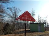 | Jablance - Plešivec (Bohor)
Plešivec, also known as Špic hill on some maps, is a 915 m high peak in Bohor, located southeast of the Bohor Cottage....
1 h 5 min |
 | Zreče (cemetery) - Golek
Golek is a 769-metre-high peak located north-west of Zreče. At the top there is a registration box with a registration book, a stamp and a bench,...
1 h 15 min |
 | Škalske Cirkovce - Stropnik
...
1 h |
 | Škalske Cirkovce - Stropnica (čez Stropnik)
...
1 h 10 min |
 | Škalske Cirkovce - Stropnica
...
1 h |