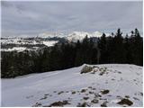
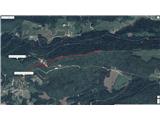
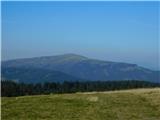
 | Polharski dom Krim - Krim
Krim is a 1107 m high mountain rising south of the Ljubljana Marshes. From the top of the mountain, where the mountain lodge and a number of tran...
1 h 35 min |
 | Bohinjsko sedlo - Možic (direct way)
Možic is a 1602 m high peak located west of Soriška mountain pasture. It is at the highest point of the peak that there is an old military bunker...
1 h 15 min |
| Bohinjsko sedlo - Možic (by Lajnar)
Možic is a 1602 m high peak located west of Soriška mountain pasture. It is at the highest point of the peak that there is an old military bunker...
1 h 30 min |
 | Vrh Bače - Možic
Možic is a 1602 m high peak located west of Soriška mountain pasture. It is at the highest point of the peak that there is an old military bunker...
1 h |
 | Radlek - Slivnica
Slivnica is a 1114 m high peak located north of Cerknica polje. The view from the summit, where the entry box is located, is rather limited due t...
1 h 20 min |
 | Volovljek - Kranjska reber
Kranjska reber or Peak Kašna planina (1435 m) is a volcanic mountain. From the top, where the registration box with the stamp is located, we have...
1 h 20 min |
 | End of road - Lepenatka
Lepenatka is a grassy peak located south of the 1557 m high Rogatec. From the top, which has a registration box and a stamp, we have a beautiful ...
1 h |
 | Leška gmajna - Lepenatka
Lepenatka is a grassy peak located south of the 1557 m high Rogatec. From the top, which has a registration box and a stamp, we have a beautiful ...
1 h 15 min |
 | Molnarjev breg - Kamniški vrh (via planina Osredek)
Kamniški vrh is a 1259 m high mountain located north of Kamnik, between Stahovica and the Korošica Valley. From the top of the peak there is a sm...
1 h 30 min |
 | Bohinjsko sedlo - Dravh (via Lajnar)
Dravh is a 1547 m high peak located between Sorica and Soriška mountain pasture. From the uncultivated summit, we have a beautiful view of Škofje...
1 h |
 | Črni Kal - Koprivnik (via Romovec)
Koprivnik is a 1393 m high mountain located between Blegoš and Mladi vrh. The view from the summit, which has a registration box and a stamp, is ...
1 h |
 | Kramarica - Smrekovec (by road)
Smrekovec is a volcanic mountain on the eastern edge of the Smrekov Mountains. The extensive grassy summit, on which stands a pyramid with a regi...
1 h 30 min |
 | Krnica - Kucelj na Čavnu (via Veliki Rob)
Kucelj is located on the southern slopes of Trnovo Forest, north-west of the Vipava valley. From the uncultivated summit on which the cross stand...
1 h 40 min |
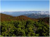
 | Mala Lazna - Mali Golak
Mali Golak is the highest of the Golaks. It was named not because it was the smallest but because it had the smallest mountain pasture. On the ma...
1 h 25 min |
 | Kozarnice - Mali Golak
Mali Golak is the highest of the Golaks. It was named not because it was the smallest but because it had the smallest mountain pasture. On the ma...
1 h 5 min |
 | Škrbina - Srednji Golak
Srednji Golak is located between Mali and Veliki Golak on the plateau of the Trnovo Forest above Predmeja. The summit is covered with dwarf pines...
1 h 15 min |
 | Lokve - Poldanovec
Poldanovec is located in Govce on the northern edge of Trnovo plateau. Govci are quickly rising above Gorenje Trebuše valley. Poldanovec is not t...
1 h 30 min |
 | Turški klanec - Mrzovec
Mrzovec is the most expressing peak in heart of Trnovo plateau. His position offers us great view, but is also limited with high trees. Thats why...
1 h 30 min |
 | Podmeja - Mrzlica
Mrzlica has become an extremely popular excursion point in the last few years, especially for visitors from the Savinjska Valley and Zasavje. At ...
1 h 15 min |
 | Podmeja - Mrzlica
Mrzlica has become an extremely popular excursion point in the last few years, especially for visitors from the Savinjska Valley and Zasavje. At ...
1 h 15 min |
 | Vrh Bače - Krevl
Krevl is a 1515 m high peak located to the south of the Kobla ski area, more precisely between Koble Peak and Kravje Črna Gora. From the summit, ...
1 h |
 | Prvine - Črni vrh (Čemšeniška planina)
Črni vrh is the highest peak of Čemšeniška mountain pasture and with a height of 1204 m it is the second highest peak in the Posavje - Zasavje hi...
1 h |
 | Planinski dom Vrhe - Črni vrh (Čemšeniška planina)
Črni vrh is the highest peak of Čemšeniška mountain pasture and with a height of 1204 m it is the second highest peak in the Posavje - Zasavje hi...
1 h 30 min |
 | Lome - Javornik above Črni vrh
Javornik is a forested peak located southeast of Črnji Vrho. In 1972, a lookout tower was erected on the summit, which reaches above the treetops...
1 h |
 | Vodice (Mali Školj) - Javornik above Črni vrh
Javornik is a forested peak located southeast of Črnji Vrho. In 1972, a lookout tower was erected on the summit, which reaches above the treetops...
1 h 30 min |
 | Kalce - Veliki Javornik (Javorniki)
Veliki Javornik is a 1,268-metre-high peak in the forested hills called the Javorniki. The vast forests of the Javorniki stretch from Postojna to...
1 h 30 min |
 | Mariborska koča - Žigartov vrh
At 1346m, Žigartov vrh is the highest peak in the eastern part of Pohorje. An "observation" tower used to stand on the summit, but was erected on...
1 h 40 min |
 | Platak - Snježnik (via crest)
Snježnik is a scenic mountain in the western part of Gorski Kotar. The summit offers a beautiful view of the Kvarner islands, the Gulf of Reška, ...
1 h 30 min |
 | Cenc - Špičasti vrh (on marked path)
Špičasti vrh is a forested mountain located south of the village of Zadlog. To ensure that the peak is not without a view, a 13m high wooden look...
1 h 30 min |
 | Podkraj - Križna gora (Hrušica) (steep way)
Križna gora is a 1162 m high peak located north of the village of Podkraj. From the top of the lookout tower, you can enjoy a beautiful view over...
1 h |
| Podkraj - Križna gora (Hrušica) (gentle path)
Križna gora is a 1162 m high peak located north of the village of Podkraj. From the top of the lookout tower, you can enjoy a beautiful view over...
1 h 20 min |
 | Podkraj - Sveti Duh (Hrušica)
The Sveti Duh Church is located just a few metres below the eponymous peak on the slopes of the forested Hrušice, a mountain range between Col, L...
1 h 15 min |
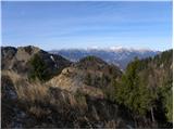
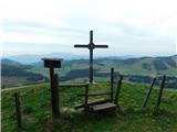
 | Koča na planini Stador - Kobilja glava
Kobilja glava is a 1475 m high peak located east of Tolmin. From the top with a cross, we have a beautiful view of the Krn, the Lower Bohinj Moun...
1 h 15 min |
 | Zgornji Goreljek - Javorov vrh (Pokljuka)
Javorov vrh is a 1482 m high mountain located between the vast forests of Pokljuka, more precisely between mountain pasture Konjska dolina and mo...
1 h 30 min |
 | Kalce - Mali Javornik (Javorniki)
Mali Javornik is a 1219 m high mountain located in the crest of the forested Javorniki Ridge. There is no view from the top due to the forest, bu...
1 h |
 | Solarji - Nagnoj
At 1193 m, Nagnoj is the second highest peak of the Kolovrat, a mountain range located between Tolmin and Venetian Slovenia. From the top, where ...
1 h 40 min |
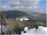
 | Soriška peč - Žbajnek
Žbajnek is a 1538 m high peak located west of Ratitovec. The grassy peak, surrounded by a rare forest, offers a beautiful view of Julian Alps, Ka...
1 h 30 min |
 | Raspet - Kopa (Cimprovka)
Kopa is a 1360 m high peak or viewing pier from which we can enjoy a beautiful view of Cerkno, the hills surrounding the above-mentioned place, R...
1 h 10 min |
 | Bohinjsko sedlo - Slatnik (southeastern peak) (via Lajnar)
Slatnik) is a scenic mountain that rises steeply above Baška Grapa on one side and descends more gently towards Soriška planina on the other side...
1 h 5 min |
| Bohinjsko sedlo - Slatnik (southeastern peak) (past barracks)
Slatnik) is a scenic mountain that rises steeply above Baška Grapa on one side and descends more gently towards Soriška planina on the other side...
1 h 10 min |
 | Dom na Paškem Kozjaku - Štrukljev vrh
Štrukljev vrh is one of the three main peaks of Paški Kozjak, a 10 km long, narrow and very steep limestone mountain range between the Paka and H...
1 h 30 min |
 | Dom na Paškem Kozjaku - Ostrica
Ostrica is an undistinguished peak of Paški Kozjak, a 10 km long and rather narrow steep limestone mountain range between the Paka and Hudinja go...
1 h |
 | Čemernica / Tschemernitzen - Arihova peč / Arichwand
Arihova peč is a scenic rock cliff located near the Blesščeče mountain pasture / Rossalm. There is a wooden hut at the top of the cliff and the c...
1 h 25 min |
 | St. John the Baptist on Ojstrica - Kozji vrh (at Košenjak)
Kozji vrh is a 1383-metre-high peak located above Pernice, and its height makes it the highest peak in the municipality of Muta....
1 h 35 min |
 | Pension Camping Holzmeister - Heulantsch
Heulantsch is a 1473m high grassy hill above the Teichalm, which together with the "Sommeralm" forms the largest area of mountain meadows in the ...
1 h 15 min |
 | Feistritzsattel - Grabmayr-Kogel
...
1 h 40 min |
 | Zelovo - Orlove stine (zahodna pot)
...
1 h 20 min |
 | Zelovo - Umac (pri Svilaji)
...
1 h 30 min |
 | Planinska koča Promina - Čavnovka (Promina) (po peš poti)
...
1 h |
 | Planinska koča Promina - Čavnovka (Promina) (po cesti)
...
1 h |
 | Feistritzsattel - Arabichl
...
1 h 20 min |
 | Teichalm (Angerwirt) - Osser
...
1 h 20 min |
 | Teichalm (Harrerhütte) - Osser
...
1 h 35 min |
| Pension Camping Holzmeister - Osser
...
1 h 15 min |