 | Wildon - Buchkogel (Wildoner Berg)
Buchkogel or Wildoner Berg is a 550 m high hill in the south of Styria, Austria. Together with the Wildoner Schlossberg (450 m) and the Bockberg ...
1 h 30 min |
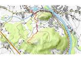
 | Lopata - Planinski dom Šentjungert
The mountain lodge is located just a few metres below the top of Gora, on which the Church of St Kunigunde, built in the 14th century, stands. Th...
1 h 30 min |
 | Treskavac - Obzova
Obzova is the highest point on the island of Krk. Like the surrounding area, the peak is completely rocky. Interesting are the puddles near the t...
1 h 30 min |
 | Ljubljana (Šentvid) - Toško Čelo
Toško Čelo is a 590 m high hill above the village of the same name. From the top, or slightly lower down, you have a beautiful view of part of Lj...
1 h 45 min |
 | Šobčev bajer - Castle Lipniški grad (Pusti grad above Lipnica) (via Fux footbridge and on natural learning trail)
Castle Lipniški grad or Pusti grad above Lipnica (Waldenberg in German) is located on a lookout over the Sava and Lipnica watercourses, more prec...
2 h 30 min |
 | Bad Gleichenberg (Eichgraben Weg) - Gleichenberger Kogel (via Steinriegel)
The Gleichenberger Kogel is a 598-metre-high volcanic mountain located above Bad Gleichenberg in Styria, Austria....
1 h 55 min |
 | Griže - Dragov dom na Homu (direct path)
Drago's home is located on a scenic hill, south of Šempeter. From the top, which is also the Church of St. Magdalene, there is a beautiful view f...
1 h 30 min |
| Griže - Dragov dom na Homu (via Zahom)
Drago's home is located on a scenic hill, south of Šempeter. From the top, which is also the Church of St. Magdalene, there is a beautiful view f...
1 h 50 min |
| Griže - Dragov dom na Homu (via Lajnarjev hrib)
Drago's home is located on a scenic hill, south of Šempeter. From the top, which is also the Church of St. Magdalene, there is a beautiful view f...
1 h 40 min |
 | Bridge over Dušica - Bajturn (Zaplaški hrib) (on north slope)
At 609 metres, Bajturn or Zaplaz Hill is the highest peak in the municipality of Trebnje. At the top there is a nice bench with a table, a box wi...
1 h 30 min |
| Okrog (Lazar) - Bajturn (Zaplaški hrib) (on ridge)
At 609 metres, Bajturn or Zaplaz Hill is the highest peak in the municipality of Trebnje. At the top there is a nice bench with a table, a box wi...
1 h 30 min |
| Okrog (Lazar) - Bajturn (Zaplaški hrib) (on north slope)
At 609 metres, Bajturn or Zaplaz Hill is the highest peak in the municipality of Trebnje. At the top there is a nice bench with a table, a box wi...
1 h 40 min |
 | Zgornje Poljčane - Rančka
...
1 h 25 min |
 | Oplotnica - Brinjeva gora (above Zreče) (above quarry)
Brinjeva gora is a remarkable hill located between Zreče and Oplotnica. Brinjeva gora is famous for its several churches, which are located in a ...
1 h 30 min |
 | Oplotnica - Brinjeva gora (above Zreče) (on forest path)
Brinjeva gora is a remarkable hill located between Zreče and Oplotnica. Brinjeva gora is famous for its several churches, which are located in a ...
1 h 30 min |
 | Naraplje - Jelovice
Jelovice with a height of 623 metres - the highest peak of the Haloze hills. The summit is accessible from several directions. It is partially vi...
1 h 40 min |
 | Višnja Gora - Sveti Duh (Polževo)
The Church of the Holy Spirit is located 630 metres above sea level, on a hill above the Polževo Hotel. The stamp is located some 10 metres away,...
1 h 30 min |
 | Povodje - Rašica (Vrh Staneta Kosca)
Vrh Staneta Kosca, better known as Rašica, is located north of Ljubljana, specifically above the village of Rašica and Dobena. From the top of th...
1 h 30 min |
 | Selo pri Vodicah - Rašica (Vrh Staneta Kosca)
Vrh Staneta Kosca, better known as Rašica, is located north of Ljubljana, specifically above the village of Rašica and Dobena. From the top of th...
1 h 30 min |
| Phliški bajer - Rašica (Vrh Staneta Kosca) (ridge path)
Vrh Staneta Kosca, better known as Rašica, is located north of Ljubljana, specifically above the village of Rašica and Dobena. From the top of th...
2 h |
| Mengeška koča na Gobavici - Rašica (Vrh Staneta Kosca) (ridge path)
Vrh Staneta Kosca, better known as Rašica, is located north of Ljubljana, specifically above the village of Rašica and Dobena. From the top of th...
2 h |
 | Mengeška koča na Gobavici - Rašica (Vrh Staneta Kosca) (lower path)
Vrh Staneta Kosca, better known as Rašica, is located north of Ljubljana, specifically above the village of Rašica and Dobena. From the top of th...
2 h |
 | Črni hribi - Trstelj
Trstelj is the highest peak in the Black Hills ridge. The view from the vast summit, where the TV transmitters stand, is split in half. From the ...
2 h |
 | Pedrovo - Trstelj
Trstelj is the highest peak in the Black Hills ridge. The view from the vast summit, where the TV transmitters stand, is split in half. From the ...
2 h |
 | Pristavlja vas - Sveti Lambert
Sveti Lambert is located on an inconspicuous peak near the village of Pristava above Stično. From the top of the hill, where the castle of the Du...
1 h 45 min |
 | Grgar - Vodice (via Ranjeke)
Vodice (according to some records also Sv. Jakob) is a peak located in the western part of the Banjška plateau. The summit, on which the mausoleu...
1 h 30 min |
 | Vuzenica - Sveti Janez Krstnik (Šentjanž nad Dravčami)
...
1 h 25 min |
 | Vuzenica - Sveti Primož (Sveti Primož na Pohorju)
...
1 h 30 min |
 | Povodje - Šmarna gora
Šmarna gora is a 669 m high peak located north-west of the capital of Slovenia. The summit, which has a restaurant and a church, offers a beautif...
1 h 30 min |
 | Povodje - Šmarna gora (via Sedlo)
Šmarna gora is a 669 m high peak located north-west of the capital of Slovenia. The summit, which has a restaurant and a church, offers a beautif...
1 h 35 min |
| Šmartno - Šmarna gora (path around Šmarna gora)
Šmarna gora is a 669 m high peak located north-west of the capital of Slovenia. The summit, which has a restaurant and a church, offers a beautif...
1 h 30 min |
 | Povodje - Šmarna gora (Partizanska steza)
Šmarna gora is a 669 m high peak located north-west of the capital of Slovenia. The summit, which has a restaurant and a church, offers a beautif...
1 h 45 min |
| Skaručna - Šmarna gora
Šmarna gora is a 669 m high peak located north-west of the capital of Slovenia. The summit, which has a restaurant and a church, offers a beautif...
1 h 30 min |
| Skaručna - Šmarna gora (via Sedlo)
Šmarna gora is a 669 m high peak located north-west of the capital of Slovenia. The summit, which has a restaurant and a church, offers a beautif...
1 h 35 min |
| Skaručna - Šmarna gora (Partizanska steza)
Šmarna gora is a 669 m high peak located north-west of the capital of Slovenia. The summit, which has a restaurant and a church, offers a beautif...
1 h 45 min |
 | Vikrče - Šmarna gora (Mazijeva steza)
Šmarna gora is a 669 m high peak located north-west of the capital of Slovenia. The summit, which has a restaurant and a church, offers a beautif...
1 h 35 min |
| Tourist farm Žurej - Žusem (Panoramska pot - stara trasa)
Žusem is a 669-metre-high hill with a colourful history and great potential for the future. It represents the northern edge of the Kozjansko regi...
1 h 40 min |
 | Turistična kmetija Žurej - Žusem (Panoramska pot)
Žusem is a 669-metre-high hill with a colourful history and great potential for the future. It represents the northern edge of the Kozjansko regi...
1 h 40 min |
 | Lokev - Kokoš
Koča na Kokoši is located at the top of Jirmanec, just 5 minutes away from the forested Kokoša. The summit, located south of the Lokavsko polje a...
1 h 30 min |
 | Povodje - Grmada
Grmada is a 676 m high mountain located to the west of the much more visited Šmarna Gora. From the top, where there is a small airstrip, we have ...
1 h 50 min |
| Skaručna - Grmada
Grmada is a 676 m high mountain located to the west of the much more visited Šmarna Gora. From the top, where there is a small airstrip, we have ...
1 h 50 min |
 | Grgar - Sveta Gora (via Frančiškov hrib)
Sveta Gora is known mainly by the faithful and locals. Sveta Gora is a well-known pilgrimage centre above Nova Gorica. It is visited by believers...
1 h 25 min |
 | Grgar - Sveta Gora (via Ranjeke)
Sveta Gora is known mainly by the faithful and locals. Sveta Gora is a well-known pilgrimage centre above Nova Gorica. It is visited by believers...
1 h 30 min |
 | Grgar - Sveta Gora (via Križce)
Sveta Gora is known mainly by the faithful and locals. Sveta Gora is a well-known pilgrimage centre above Nova Gorica. It is visited by believers...
1 h 30 min |
 | Šentjur - Resevna
Resevna is a peak located south of Šentjur. On the top is a 20m high lookout tower, which gives us a beautiful view of almost the whole of Sloven...
1 h 30 min |
| Jakob pri Šentjurju - Resevna
Resevna is a peak located south of Šentjur. On the top is a 20m high lookout tower, which gives us a beautiful view of almost the whole of Sloven...
1 h 30 min |
 | Brezno - Sveti Jurij (Remšnik) (along Remšniški potok)
The Church of St George is situated on a lookout point in the settlement Remšnik, which is on the slopes of Kozjak. Opposite the church, next to ...
1 h 35 min |
 | Pristavlja vas - Pristava above Stična
Pristava above Stična is a small village located on a scenic hill north of Stična. A little above the village, by the Partisan House, there is a ...
1 h 45 min |
 | Straßengel - Generalkogel
...
1 h 30 min |
 | Prelaz Vrhe - Maceljska gora (via source of Sotla)
...
1 h 50 min |
 | Radlje ob Dravi - Sveti Anton na MP Radelj / St. Anton am Radlpaß (via old castle)
The Church of St Anton at Border crossing Radelj / St Anton am Radlpaß is located on the Austrian side of the Kozjak Mountains, on a 720-metre-hi...
2 h 15 min |
 | Vrzdenec - Koreno (via Samotorica)
Koreno also Koreno is a 729 m high hill located north of Horjul. From the top, where there is a large cross, the Church of St. Mohorj and Fortuna...
1 h 45 min |
 | Polhov Gradec - Koreno
Koreno also Koreno is a 729 m high hill located north of Horjul. From the top, where there is a large cross, the Church of St. Mohorj and Fortuna...
1 h 45 min |
| Krka - Ciganov vrh (Korinjski hrib) (part of circular path Prijetno domače)
Ciganov vrh or Korinjski hill is a small hill rising above the valley of the river Krka, from which we have a view of the rather woded surroundin...
1 h 45 min |
 | Vrhnika-Tankovska cesta - Koča na Planini nad Vrhniko (Circular path Vrhnika-Planina-Lintvern-Vrhnika)
Planina above Vrhnika is for hers inhabitants something like Šmarna gora for inhabitants of Ljubljana. It is 733 metres high and is reachable fro...
2 h 20 min |
 | Podvin pri Polzeli - Gora Oljka (upper path)
Gora Oljka is a hill located east of Šmartno ob Paki. On the top stands the Church of the Holy Cross, which was built in the mid-18th century. Ju...
1 h 35 min |
| Podvin pri Polzeli - Gora Oljka (lower path)
Gora Oljka is a hill located east of Šmartno ob Paki. On the top stands the Church of the Holy Cross, which was built in the mid-18th century. Ju...
1 h 30 min |
 | Rein - Pfaffenkogel
...
1 h 30 min |
 | Moravče - Sveti Miklavž above Sava
The Church of St Nicholas is situated on a hill south of Moravče. From the top you can enjoy a beautiful view of the nearby Limbarska gora, and t...
1 h 25 min |
 | Predgrad - Kozice (by road)
Kozice is a 741-metre-high peak with an RTV transmitter located above the left bank of the Kolpa River. From the lookout point on the southern pe...
1 h 30 min |
 | Divje jezero - Zagrebenc
Zagrebenc on some maps also Čekovnik is a 763 m high peak located between Hleviška planina and the valley of the Idrijca River. The grassy peak, ...
1 h 30 min |
 | Zreče (Terme Zreče) - Golek
Golek is a 769-metre-high peak located north-west of Zreče. At the top there is a registration box with a registration book, a stamp and a bench,...
1 h 25 min |
| Zreče (Terme Zreče) - Golek (via Bork)
Golek is a 769-metre-high peak located north-west of Zreče. At the top there is a registration box with a registration book, a stamp and a bench,...
1 h 30 min |
| Zreče (Terme Zreče) - Golek (via Tourist farm Ančka)
Golek is a 769-metre-high peak located north-west of Zreče. At the top there is a registration box with a registration book, a stamp and a bench,...
1 h 35 min |
 | Moravče - Limbarska gora (via Serjuče)
Limbarska gora is located north-east of Moravce. From the top there is a beautiful view of the surrounding peaks and in good weather you can also...
1 h 25 min |
 | Moravče - Limbarska gora (via Gabrje)
Limbarska gora is located north-east of Moravce. From the top there is a beautiful view of the surrounding peaks and in good weather you can also...
1 h 35 min |
 | Blagovica - Limbarska gora
Limbarska gora is located north-east of Moravce. From the top there is a beautiful view of the surrounding peaks and in good weather you can also...
1 h 30 min |
 | Legastja - Jeterbenk
Jeterbenk is a 774 m high peak located between Slavko's home at Gole Brdo and Katarina (Topol village). From the top, where there is a large cros...
1 h 40 min |
 | Marno - Vrhe (pri Gorah)
...
1 h 25 min |
 | Žlebe - Rog (via Turnice)
The Rog is a 798 m high peak located above the village of Topole, just 10 minutes from St Catherine's Church. From the top of the hill, where a l...
1 h 30 min |
| Žlebe - Rog (via Jeterbenk)
The Rog is a 798 m high peak located above the village of Topole, just 10 minutes from St Catherine's Church. From the top of the hill, where a l...
1 h 40 min |
 | Zazid - Lipnik
Lipnik is an 804 m high peak located above the village of Rakitovec on the Slovenian Croatian border. From the top, where there is a cross and a ...
1 h 40 min |