 | Sant'Uberto - Vallon Bianco
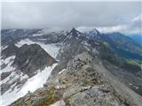
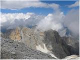
Vallon Bianco (Valun Blanch in Ladin) is a 2688 metre high peak above the Valle di Fanes and Val Travenanzes. From the top, where a small cross a...
5 h 5 min |
| Rifugio Pederü - Vallon Bianco
Vallon Bianco (Valun Blanch in Ladin) is a 2688 metre high peak above the Valle di Fanes and Val Travenanzes. From the top, where a small cross a...
4 h 40 min |
 | Plöckenpass - Creta di Collina / Kollinkofel (path 171)
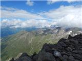
Creta di Collina (German: Kollinkofel) is a 2,691-metre-high mountain in Carnic Alpsah. Several military trails and ruins from the First World Wa...
4 h |
 | Plöckenpass - Creta di Collina / Kollinkofel (via Cresta Verde)
Creta di Collina (German: Kollinkofel) is a 2,691-metre-high mountain in Carnic Alpsah. Several military trails and ruins from the First World Wa...
4 h |
 | Alba di Canazei - Colac (path 646)
Colac is a 2715 m high mountain located in the west of the Marmolada mountain group. From the summit on which the cross stands, there is a beauti...
4 h |
 | Prebersee - Roteck
Roteck is a 2742m high peak located north of the Tamsweg in the heart of the Low Tatras. From the summit on which the cross stands, there is a be...
4 h |
 | Piano Fiscalino / Fischleinboden - Monte Paterno (Ferrata De Luca-Innerkofler)
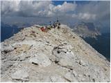
Monte Paterno is a 2744 metre high lookout. The view from the top is spectacular on all sides, with the Tri Cine/Tre Cime to the west standing ou...
4 h 10 min |
 | Plockenpass - Pilastro del Coglians
Pilastro del Coglians is a 2750 m high peak located east of Monte Coglians on the border between Austria and Itali. There is also a registration ...
4 h 30 min |
| Rifugio Tolazzi - Pilastro del Coglians (via Rifugio Marinelli)
Pilastro del Coglians is a 2750 m high peak located east of Monte Coglians on the border between Austria and Itali. There is also a registration ...
3 h 55 min |
 | Plöckenpass - Creta della Chianevate / Kellerspitzen (path 171)
Creta della Chianevate (German: Kellerspitzen) is a 2,769-metre-high peak in the central part of Carnic Alps on the border between Austria and It...
4 h 50 min |
| Plöckenpass - Creta della Chianevate / Kellerspitzen (via Cresta Verde)
Creta della Chianevate (German: Kellerspitzen) is a 2,769-metre-high peak in the central part of Carnic Alps on the border between Austria and It...
5 h |
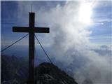
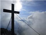
 | Rifugio Pederü - Furcia Rossa III
Furcia Rossa III is a 2791 m high peak in a slightly more secluded ridge over which the Fridensweg / Via della pace leads. At the top, next to th...
4 h 50 min |
| Sant'Uberto - Furcia Rossa III
Furcia Rossa III is a 2791 m high peak in a slightly more secluded ridge over which the Fridensweg / Via della pace leads. At the top, next to th...
5 h 15 min |
 | Passo di Costalunga / Karerpass - Roda di Vael / Rotwand (Via Ferrata Majare)
Roda di Vael (German: Rotwand) is a 2806 metre high mountain in the Catinaccio (Rosengarten) mountain group. The mountain is mainly known for its...
5 h 30 min |
 | Ristorante Pietofana - Cima Formenton (via Rifugio Pomedes)
Cima Formenton is a 2830 m high peak in the Tofana mountain group. The mountain is located to the north of the better known Tofana di Dentro, and...
5 h 5 min |
 | end of road on Pokljuka - Triglav (via Kredarica)
Triglav is a 2864 m high mountain located in the heart of the Julian Alps. With its height, Triglav is the highest mountain in Slovenia and the h...
6 h 10 min |
| end of road on Pokljuka - Triglav (via Planika and Mali Triglav)
Triglav is a 2864 m high mountain located in the heart of the Julian Alps. With its height, Triglav is the highest mountain in Slovenia and the h...
6 h |
| Uskovnica (Razpotje) - Triglav (via Planika and Mali Triglav)
Triglav is a 2864 m high mountain located in the heart of the Julian Alps. With its height, Triglav is the highest mountain in Slovenia and the h...
6 h 15 min |
 | Uskovnica (Razpotje) - Triglav (via Triglavska škrbina)
Triglav is a 2864 m high mountain located in the heart of the Julian Alps. With its height, Triglav is the highest mountain in Slovenia and the h...
6 h |
| Rudno polje - Triglav (via Kredarica)
Triglav is a 2864 m high mountain located in the heart of the Julian Alps. With its height, Triglav is the highest mountain in Slovenia and the h...
6 h 30 min |
| Rudno polje - Triglav (via Dom Planika and Mali Triglav)
Triglav is a 2864 m high mountain located in the heart of the Julian Alps. With its height, Triglav is the highest mountain in Slovenia and the h...
6 h 20 min |
 | Parking Erichhütte - Hoher Kopf (path 432)
Hocher Kopf is located in the Berchtesgaden Alps, west of the highest peak, Höchkonig. The summit is well visited, especially because of the Köni...
4 h 45 min |
 | Parkplatz Erichhütte - Hochkönig (path 432)
At 2941 metres, Hochkönig is the highest peak in the Berchtesgaden Alps. The summit on which the Matrashaus hut stands is very well visited. From...
5 h 20 min |
 | Parkplatz Innerfragant - Alteck (via Fraganter Scharte)
Alteck is a 2942 metre high peak rising steeply above the Hochwurtenspeicher lake at the Mölltaler Glacier ski resort. From the summit, on which ...
7 h |
 | Obermoos - Zugspitze (Stopselziehersteig)
At 2962 metres, Zugspitze is the highest peak in the Wetterstein mountain group and the highest peak in Germany. The mountain is located south of...
5 h |
 | Piano Fiscalino / Fischleinboden - Croda Rossa di Sesto (Via Ferrata Croda Rossa)
Croda Rossa di Sesto (German: Sextner Rotwand, also Zehner) is a 2,965-metre-high mountain in the Sexten Dolomites (Dolomiti di Sesto). The mount...
5 h |
 | Rifugio Pederü - Cima Nove / Neunerspitze
The Italian Cima Nove or Sasso delle Nove, the German Neuner or Neunerspitze, the Ladin Sas dles Nü or Nönör is a 2,968-metre high peak in the Fa...
4 h 50 min |
 | Türlwandhütte - Hoher Dachstein (via Hunerscharte)
At 2995 metres, Hoher Dachstein is the highest peak of the Dachstein mountain group. It is located on the border between Steiermark and Oberöster...
5 h 45 min |
 | Alba di Canazei - Cima Ombretta (Via Ferrata Ombretta)
Cima Ombretta is a 3011-metre peak in the Marmolada mountain group. The summit on which the cross stands offers the best view of the nearby south...
5 h 15 min |
 | Rifugio Pederü - Sasso delle Dieci / Zehnerspitze (path 12)
Sasso delle Dieci is a 3,028-metre-high mountain rising steeply above the Val Badia valley. Sasso delle Dieci is the highest peak in the Sasso de...
5 h 30 min |
| Rifugio Pederü - Sasso delle Dieci / Zehnerspitze (path 7)
Sasso delle Dieci is a 3,028-metre-high mountain rising steeply above the Val Badia valley. Sasso delle Dieci is the highest peak in the Sasso de...
5 h 35 min |
 | Lenzanger - Goldzechkopf (via Hoher Sonnblick)
Goldzechkopf is a 3,042-metre peak in the Goldberg Mountain Group. The peak is located on the ridge between the better known Hoher Sonnblick and ...
6 h 10 min |
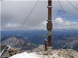
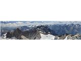
 | Rifugio Pederü - Piz dles Conturines
At 3064m, Piz dles Conturines is the highest peak in the Lavarella mountain group. From the summit, where the cross stands, you have a beautiful ...
6 h 30 min |
 | Malga Fosse - Il Nuvolo
Il Nuvolo is a 3,075-metre-high peak in the Pale di San Martino mountain group. The mountain is located above the Valle dei Cantoni, close to the...
5 h 40 min |
 | Sporthotel Maltatal - Großer Hafner
Großer Hafner is the highest peak of the Hafner Gruppe at 3076m. From the summit on which the cross stands, there is a beautiful view across the ...
4 h 30 min |
 | Lenzanger - Hoher Sonnblick (via Goldzechkopf)
Hoher Sonnblick aka Rauriser Sonnblick is a 3106 metre high mountain in the Goldberg mountain group. The Zittelhaus hut and the highest meteorolo...
6 h 30 min |
 | Passo Campolongo - Cresta Strenta (Via Ferrata Vallon)
Cresta Strenta is a less prominent peak north of Piz Boe. The summit offers a very fine view over most of the Dolomites. At 3124 metres, Cresta S...
4 h 25 min |
 | Passo Campolongo - Piz Boe (Via Ferrata Vallon)
At 3152 metres, Piz Boe is the highest peak in the Sella mountain group in the Italian Dolomites. From the top, you have a beautiful view of the ...
4 h 40 min |
 | Malga Fosse - Cima Vezzana (Via Ferrata Bolver Lugli)
At 3192 metres, Cima di Vezzana is the highest peak in the Pale di San Martino mountain group. The summit offers a very fine view over most of th...
4 h 30 min |
| Malga Fosse - Cima Vezzana
At 3192 metres, Cima di Vezzana is the highest peak in the Pale di San Martino mountain group. The summit offers a very fine view over most of th...
6 h 10 min |
 | Seichenbrunn - Glödis
Glödis or Glödisspitze is a 3206 metre high mountain in the Schober mountain group in the High Tauern National Park (Nationalpark Hohe Tauern). F...
5 h |
 | Palafavera - Monte Civetta (Via Normale)
Monte Civetta is one of the main mountains in the Dolomites. It is particularly notable for its north-west face, which is more than 1000 metres h...
6 h 20 min |
 | Leibnitzbachbrücke - Hochschober (via Staniskascharte)
Hochschober is a 3,240-metre-high mountain in the Schober Group. Although it is the fourth highest mountain in the group, it is the mountain that...
5 h |
 | Gschnitz - Habicht (običajna pot mimo Innsbrucker Hütte (Gschnitz))
Habicht (Slovene: "kragulj") is a bald and mighty mountain rising high above the Stubai and Obertal valleys; its somewhat isolated position (it i...
5 h 30 min |
| Parkirišče pri gostišču Feuerstein - Habicht (običajna pot mimo Innsbrucker Hütte (Feuerstein))
Habicht (Slovene: "kragulj") is a bald and mighty mountain rising high above the Stubai and Obertal valleys; its somewhat isolated position (it i...
5 h 15 min |
 | Alba di Canazei - Punta Penia (Marmolada)
At 3343 m, Punta Penia is the highest peak in the Marmolada and also in the Italian Dolomites. From the top of the peak, where there is a small m...
6 h 15 min |
 | Parkirišče pred Plangeroßom v Pitztalu - Hohe Geige (smer preko zahodnega grebena (I-II))
With a height of between 3393 and 3396 m, Hohe Geige is one of the highest and most important peaks in the northern part of the Ötztal Alps. As t...
5 h |