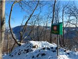
 | Rakovnik - Sveti Florijan (Tehovec) (via Breznik)
The Church of St Florian is a branch church located in the village Tehovec above Medvode. The church, which was first mentioned in 1548, offers a...
1 h 20 min |
 | Fala Grad - Lobnikov vrh
Lobnikov vrh is a forested peak above the Drava Valley, situated between Fala and Ruta. From the east, it loks like a solitary rock due to its di...
1 h 15 min |
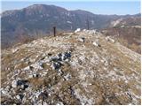
 | Rudnik pri Radomljah - Tolsta gora
Tolsta gora is a 734-metre-high mountain located above Vrhpolje near Kamnik. From the top, where cairn stands, there is no better view, thanks to...
1 h 25 min |
 | Škofja Loka - Vrh soteske (Križna gora)
Vrh soteske is a 735 m high peak located in the south-western part of Križna Gora. There is no better view from the top, which is covered by fore...
1 h 25 min |
 | Rudnik pri Radomljah - Vrtače (via Lancar)
Vrtače is a 758-metre-high peak located above the village of Zgornje Palovče. The peak is covered with forest, but the clearing slightly below th...
1 h 30 min |
 | Zreče (Terme Zreče) - Golek (steep path)
Golek is a 769-metre-high peak located north-west of Zreče. At the top there is a registration box with a registration book, a stamp and a bench,...
1 h 20 min |
 | Liboje (quarry) - Kotečnik (via eastern ridge)
Kotečnik is a peak in Posavsko hribovje, located north of Šmohor. Kotečnik is a peak with two entry boxes. The first one is located on the wester...
1 h 5 min |
 | Hotavlje - Vrh Slajke
Vrh Slajke is a 790-metre-high hill located above Hotavlje, on the right bank of the Kopačnice River. From the top, where the antenna tower stand...
1 h 15 min |
| Hotavlje - Vrh Slajke (via Bela)
Vrh Slajke is a 790-metre-high hill located above Hotavlje, on the right bank of the Kopačnice River. From the top, where the antenna tower stand...
1 h 30 min |
 | Slavkov dom na Golem Brdu - Rog
The Rog is a 798 m high peak located above the village of Topole, just 10 minutes from St Catherine's Church. From the top of the hill, where a l...
1 h 40 min |
 | Spodnja Idrija - Cerkovni vrh
Cerkovni vrh is a broadleaved stump above Spodnja Idrija. From the top we have beautiful views of local peaks such as Kobalove mountain pasture, ...
1 h 15 min |
 | Zgornja Rečica (Maček) - Govško brdo (mimo pastirske kapelice)
Govško brdo is an 811m high hill located west of the village of Huda jama above Laško. From the top of the hill, where the registration box and s...
1 h 35 min |
 | Selnica ob Dravi - Janžev vrh
...
1 h 35 min |
| Janževa Gora - Janžev vrh (mimo cerkve sv. Janeza Krstnika)
...
1 h 35 min |
 | Hotovlja - Bukov vrh (by road)
Bukov vrh, on which the Church of the Sorrowful Mother of God stands, is located in the north-western part of the Polhograje hills. From the top ...
1 h 30 min |
 | Ožbalt (jez na potoku Črmenica) - Grilov vrh (po kolovozu)
...
1 h 40 min |
 | Dravograd (Meža) - Sveti Danijel (above Trbonje)
The Church of St. Danijel is located on the outskirts of the village of St. Danijel, just above Trbonyi. From the church we have a beautiful view...
1 h 30 min |
 | Source of Hubelj - Otliški maj
Otliški maj is a scenic peak located south of Otlica. From the top there is a beautiful view towards the Vipava valley, the slopes of Čavna, Gola...
1 h 25 min |
 | Mlinše - Zasavska Sveta gora
Zasavska Sveta gora is a popular excursion point located between Litija and Izlaki. From the top, where the parish church of the Nativity of the ...
1 h 30 min |
 | Polhov Gradec - Mala Grmada (via Ravnek and via Sveta Uršula)
Mala Grmada is an 853 m high peak located south-west of the slightly higher Polhograjska Grmada. From the top, you have a beautiful view over the...
1 h 35 min |
| Polhov Gradec (Božna) - Mala Grmada (via Sveta Uršula)
Mala Grmada is an 853 m high peak located south-west of the slightly higher Polhograjska Grmada. From the top, you have a beautiful view over the...
1 h 10 min |
 | Gosteče - Osolnik (via Vidmovec)
Osolnik is an 858 m high mountain located south of Škofja Loka and west of Medvode. From the top, where the Church of St. Mohor and Fortunatus st...
1 h 30 min |
 | Sveta Barbara (Nova Hrastnica) - Sveti Ožbolt (above Zminec)
Sveti Ožbolt is located on a scenic peak in the north of the Polhograjske Dolomites. It has a beautiful view of the Škofjeloško hribovje and part...
1 h 40 min |
 | Cerkno - Veliki vrh (Lajše) (on unmarked path)
Veliki vrh is an almost 900 m high peak rising south of Cerkno. From the top, where there are several television and radio transmitters covering ...
1 h 40 min |
| Nevlje pri Kamniku - Vovar
An obscure hill in front of the Kamnik mountains. Recently covered by storms, it has been covered with wood harvesting tracks.There is also a sma...
1 h 30 min |