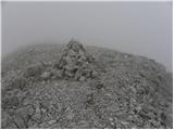
 | Sella Nevea - Vrh Krnice
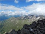
Vrh Krnice is a 2441 m high peak located north-west of Visoki Kanin. From the summit, where the usually empty registration box stands, you can en...
5 h 15 min |
 | Rifugio Padova - Cima Montanel (via Forcella di Crodon)
Cima Montanel is a 2,461-metre-high peak overloking the Piave Valley in the Carnioan Pre-Alps. The summit on which the cross is erected is a rema...
4 h 50 min |
 | Sella Nevea - Foronon del Buinz / Špik nad Nosom (via Forcella Lavinal dell Orso)
Foronon del Buinz is a 2531 m high mountain located in the mountain ridge between Jôf di Montasio and Viš. The rocky peak offers a view of the Vi...
6 h |
 | Klammbrückl - Weittalspitze (Allmaier Toni Weg)
Weittalspitze is a 2,539-metre-high peak in the Lienz Dolomites. The summit is located south of the mountain pasture Kerschbaumeralm. From the su...
4 h 30 min |
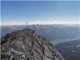
 | Vršič - Prisank / Prisojnik (Jubilejna pot)
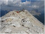
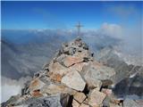
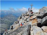
Prisank is a 2547 m high mountain located above the valleys of Mlinarica, Krnica and Suha Pišnica. From the top of the peak, where the registrati...
6 h |
 | Koča na Gozdu - Prisank / Prisojnik (Hanzova pot)
Prisank is a 2547 m high mountain located above the valleys of Mlinarica, Krnica and Suha Pišnica. From the top of the peak, where the registrati...
5 h |
| Erjavčeva koča na Vršiču - Prisank / Prisojnik (Jubilejna pot)
Prisank is a 2547 m high mountain located above the valleys of Mlinarica, Krnica and Suha Pišnica. From the top of the peak, where the registrati...
6 h 15 min |
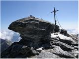
 | Sella Nevea - Visoki Kanin (Via ferrata Rosalba Grasselli)
Visoki Kanin is the highest peak of the Kanin Mountains. From the summit on which the cross stands, you have a beautiful view of the western Juli...
6 h 15 min |
 | Sella Nevea - Visoki Kanin (Via ferrata Divisione Julia)
Visoki Kanin is the highest peak of the Kanin Mountains. From the summit on which the cross stands, you have a beautiful view of the western Juli...
4 h 45 min |
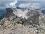
 | Vršič - Razor
The summit is located above the Alpine valley of Mlinarica. The summit, which is not spacious, has a very nice view. All the peaks above the Kriš...
6 h |
 | Vršič - Jalovec (via Jalovška škrbina)
Jalovec is the sixth highest mountain in Slovenia with a height of 2645 m. The summit, which descends steeply towards three Alpine valleys (Loška...
6 h |
| Vršič - Jalovec (via zavetišče pod Špičkom)
Jalovec is the sixth highest mountain in Slovenia with a height of 2645 m. The summit, which descends steeply towards three Alpine valleys (Loška...
6 h 30 min |
 | Dom v Tamarju - Jalovec (via Kotovo sedlo)
Jalovec is the sixth highest mountain in Slovenia with a height of 2645 m. The summit, which descends steeply towards three Alpine valleys (Loška...
5 h 15 min |
| Dom v Tamarju - Jalovec (via Jalovška škrbina)
Jalovec is the sixth highest mountain in Slovenia with a height of 2645 m. The summit, which descends steeply towards three Alpine valleys (Loška...
5 h 45 min |
| Dom v Tamarju - Jalovec (on scree and over Kotovo sedlo)
Jalovec is the sixth highest mountain in Slovenia with a height of 2645 m. The summit, which descends steeply towards three Alpine valleys (Loška...
5 h 15 min |
 | Parkirišče Stupfer v dolini Gaistal - Hohe Munde - western peak (po plezalni poti preko zahodnega grebena)
Hohe Munde is a peak in the Mieming Mountains west of Innsbruck and the home mountain of the town of Telfs, overloked by an imposing rock fortres...
6 h 15 min |
 | Pri Mlinču - Mangart (slovenska pot)
Mangart (also Mangrt, both spellings are grammatically correct) is a mountain that receives a very high number of visitors in summer. Access to t...
4 h 45 min |
 | Sant'Uberto - Vallon Bianco
Vallon Bianco (Valun Blanch in Ladin) is a 2688 metre high peak above the Valle di Fanes and Val Travenanzes. From the top, where a small cross a...
5 h 5 min |
| Rifugio Pederü - Vallon Bianco
Vallon Bianco (Valun Blanch in Ladin) is a 2688 metre high peak above the Valle di Fanes and Val Travenanzes. From the top, where a small cross a...
4 h 40 min |
 | Klammbrückl - Spitzkofel
Spitzkofel is a 2,717-metre-high mountain in the Lienz Dolomites. From the top, where a large cross stands, you have a very nice view of the whol...
5 h |
 | Plockenpass - Pilastro del Coglians
Pilastro del Coglians is a 2750 m high peak located east of Monte Coglians on the border between Austria and Itali. There is also a registration ...
4 h 30 min |
 | Plöckenpass - Creta della Chianevate / Kellerspitzen (path 171)
Creta della Chianevate (German: Kellerspitzen) is a 2,769-metre-high peak in the central part of Carnic Alps on the border between Austria and It...
4 h 50 min |
| Plöckenpass - Creta della Chianevate / Kellerspitzen (via Cresta Verde)
Creta della Chianevate (German: Kellerspitzen) is a 2,769-metre-high peak in the central part of Carnic Alps on the border between Austria and It...
5 h |
 | Capanna Alpina - Furcia Rossa III
Furcia Rossa III is a 2791 m high peak in a slightly more secluded ridge over which the Fridensweg / Via della pace leads. At the top, next to th...
4 h 30 min |
| Rifugio Pederü - Furcia Rossa III
Furcia Rossa III is a 2791 m high peak in a slightly more secluded ridge over which the Fridensweg / Via della pace leads. At the top, next to th...
4 h 50 min |
| Sant'Uberto - Furcia Rossa III
Furcia Rossa III is a 2791 m high peak in a slightly more secluded ridge over which the Fridensweg / Via della pace leads. At the top, next to th...
5 h 15 min |
 | Passo di Costalunga / Karerpass - Roda di Vael / Rotwand (Via Ferrata Majare)
Roda di Vael (German: Rotwand) is a 2806 metre high mountain in the Catinaccio (Rosengarten) mountain group. The mountain is mainly known for its...
5 h 30 min |
 | Ristorante Pietofana - Cima Formenton (via Rifugio Pomedes)
Cima Formenton is a 2830 m high peak in the Tofana mountain group. The mountain is located to the north of the better known Tofana di Dentro, and...
5 h 5 min |
 | end of road on Pokljuka - Triglav (via Kredarica)
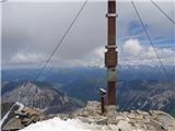
Triglav is a 2864 m high mountain located in the heart of the Julian Alps. With its height, Triglav is the highest mountain in Slovenia and the h...
6 h 10 min |
| end of road on Pokljuka - Triglav (via Planika and Mali Triglav)
Triglav is a 2864 m high mountain located in the heart of the Julian Alps. With its height, Triglav is the highest mountain in Slovenia and the h...
6 h |
| Uskovnica (Razpotje) - Triglav (via Planika and Mali Triglav)
Triglav is a 2864 m high mountain located in the heart of the Julian Alps. With its height, Triglav is the highest mountain in Slovenia and the h...
6 h 15 min |
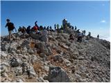 | Planina Blato - Triglav (Za Kopico)
Triglav is a 2864 m high mountain located in the heart of the Julian Alps. With its height, Triglav is the highest mountain in Slovenia and the h...
7 h 45 min |
 | Uskovnica (Razpotje) - Triglav (via Triglavska škrbina)
Triglav is a 2864 m high mountain located in the heart of the Julian Alps. With its height, Triglav is the highest mountain in Slovenia and the h...
6 h |
| Rudno polje - Triglav (via Kredarica)
Triglav is a 2864 m high mountain located in the heart of the Julian Alps. With its height, Triglav is the highest mountain in Slovenia and the h...
6 h 30 min |
| Rudno polje - Triglav (via Dom Planika and Mali Triglav)
Triglav is a 2864 m high mountain located in the heart of the Julian Alps. With its height, Triglav is the highest mountain in Slovenia and the h...
6 h 20 min |
 | Türlwandhütte - Großer Koppenkarstein (via Hunerscharte)
Großer Koppenkarstein is a 2865 metre high mountain in the Dachstein mountain group. It is located above the Schladminger Glacier. From the top w...
4 h 50 min |
 | Parking Erichhütte - Hoher Kopf (path 432)
Hocher Kopf is located in the Berchtesgaden Alps, west of the highest peak, Höchkonig. The summit is well visited, especially because of the Köni...
4 h 45 min |
 | Parkplatz Erichhütte - Hochkönig (path 432)
At 2941 metres, Hochkönig is the highest peak in the Berchtesgaden Alps. The summit on which the Matrashaus hut stands is very well visited. From...
5 h 20 min |
 | Parkplatz Innerfragant - Alteck (via Fraganter Scharte)
Alteck is a 2942 metre high peak rising steeply above the Hochwurtenspeicher lake at the Mölltaler Glacier ski resort. From the summit, on which ...
7 h |
 | Obermoos - Zugspitze (Stopselziehersteig)
At 2962 metres, Zugspitze is the highest peak in the Wetterstein mountain group and the highest peak in Germany. The mountain is located south of...
5 h |
 | Piano Fiscalino / Fischleinboden - Croda Rossa di Sesto (Via Ferrata Croda Rossa)
Croda Rossa di Sesto (German: Sextner Rotwand, also Zehner) is a 2,965-metre-high mountain in the Sexten Dolomites (Dolomiti di Sesto). The mount...
5 h |
 | Rifugio Pederü - Cima Nove / Neunerspitze
The Italian Cima Nove or Sasso delle Nove, the German Neuner or Neunerspitze, the Ladin Sas dles Nü or Nönör is a 2,968-metre high peak in the Fa...
4 h 50 min |
 | Türlwandhütte - Hoher Dachstein (via Hunerscharte)
At 2995 metres, Hoher Dachstein is the highest peak of the Dachstein mountain group. It is located on the border between Steiermark and Oberöster...
5 h 45 min |
 | Alba di Canazei - Cima Ombretta (Via Ferrata Ombretta)
Cima Ombretta is a 3011-metre peak in the Marmolada mountain group. The summit on which the cross stands offers the best view of the nearby south...
5 h 15 min |
 | Rifugio Pederü - Sasso delle Dieci / Zehnerspitze (path 12)
Sasso delle Dieci is a 3,028-metre-high mountain rising steeply above the Val Badia valley. Sasso delle Dieci is the highest peak in the Sasso de...
5 h 30 min |
| Rifugio Pederü - Sasso delle Dieci / Zehnerspitze (path 7)
Sasso delle Dieci is a 3,028-metre-high mountain rising steeply above the Val Badia valley. Sasso delle Dieci is the highest peak in the Sasso de...
5 h 35 min |
 | Rifugio Pederü - Piz dles Conturines
At 3064m, Piz dles Conturines is the highest peak in the Lavarella mountain group. From the summit, where the cross stands, you have a beautiful ...
6 h 30 min |
 | Malga Fosse - Il Nuvolo
Il Nuvolo is a 3,075-metre-high peak in the Pale di San Martino mountain group. The mountain is located above the Valle dei Cantoni, close to the...
5 h 40 min |
 | Sporthotel Maltatal - Großer Hafner
Großer Hafner is the highest peak of the Hafner Gruppe at 3076m. From the summit on which the cross stands, there is a beautiful view across the ...
4 h 30 min |
 | Parkplatz Innerfragant - Schareck (via Fraganter Scharte)
Schareck is a 3123-metre peak above the Wurtenkees Glacier in the Goldberg Group. The summit is very well visited due to the proximity of the cab...
7 h 20 min |
 | Passo Campolongo - Cresta Strenta (Via Ferrata Vallon)
Cresta Strenta is a less prominent peak north of Piz Boe. The summit offers a very fine view over most of the Dolomites. At 3124 metres, Cresta S...
4 h 25 min |
 | Passo Campolongo - Piz Boe (Via Ferrata Vallon)
At 3152 metres, Piz Boe is the highest peak in the Sella mountain group in the Italian Dolomites. From the top, you have a beautiful view of the ...
4 h 40 min |
 | Malga Fosse - Cima Vezzana (Via Ferrata Bolver Lugli)
At 3192 metres, Cima di Vezzana is the highest peak in the Pale di San Martino mountain group. The summit offers a very fine view over most of th...
4 h 30 min |
| Malga Fosse - Cima Vezzana
At 3192 metres, Cima di Vezzana is the highest peak in the Pale di San Martino mountain group. The summit offers a very fine view over most of th...
6 h 10 min |
 | Seichenbrunn - Glödis
Glödis or Glödisspitze is a 3206 metre high mountain in the Schober mountain group in the High Tauern National Park (Nationalpark Hohe Tauern). F...
5 h |
 | Palafavera - Monte Civetta (Via Normale)
Monte Civetta is one of the main mountains in the Dolomites. It is particularly notable for its north-west face, which is more than 1000 metres h...
6 h 20 min |
 | Leibnitzbachbrücke - Hochschober (via Staniskascharte)
Hochschober is a 3,240-metre-high mountain in the Schober Group. Although it is the fourth highest mountain in the group, it is the mountain that...
5 h |
 | Gschnitz - Habicht (običajna pot mimo Innsbrucker Hütte (Gschnitz))
Habicht (Slovene: "kragulj") is a bald and mighty mountain rising high above the Stubai and Obertal valleys; its somewhat isolated position (it i...
5 h 30 min |
| Parkirišče pri gostišču Feuerstein - Habicht (običajna pot mimo Innsbrucker Hütte (Feuerstein))
Habicht (Slovene: "kragulj") is a bald and mighty mountain rising high above the Stubai and Obertal valleys; its somewhat isolated position (it i...
5 h 15 min |
 | Alba di Canazei - Punta Penia (Marmolada)
At 3343 m, Punta Penia is the highest peak in the Marmolada and also in the Italian Dolomites. From the top of the peak, where there is a small m...
6 h 15 min |
 | Gößgraben - Hochalmspitze (via Steinerne Mandln)
The Hochalmspitze (also Hochalmer), often called Queen High Tauern, is the highest mountain in the Ankogel mountain group at 3360 metres. The mou...
5 h 30 min |
 | Gößgraben - Hochalmspitze (Detmolder Grat)
The Hochalmspitze (also Hochalmer), often called Queen High Tauern, is the highest mountain in the Ankogel mountain group at 3360 metres. The mou...
5 h 30 min |
 | Parkirišče pred Plangeroßom v Pitztalu - Hohe Geige (smer preko zahodnega grebena (I-II))
With a height of between 3393 and 3396 m, Hohe Geige is one of the highest and most important peaks in the northern part of the Ötztal Alps. As t...
5 h |