 | Topol - Polhograjska Grmada
Polhograjska Grmada is an 898 m high peak located in the heart of the Polhograjski Dolomiti. The summit, which has a registration box with a stam...
1 h 15 min |
| Belo - Polhograjska Grmada
Polhograjska Grmada is an 898 m high peak located in the heart of the Polhograjski Dolomiti. The summit, which has a registration box with a stam...
1 h 20 min |
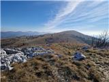
 | Selo - Sveti Ožbolt (above Zminec)
Sveti Ožbolt is located on a scenic peak in the north of the Polhograjske Dolomites. It has a beautiful view of the Škofjeloško hribovje and part...
1 h 15 min |
 | Selo - Mlaka
Mlaka or Prosen's Hill is a vegetated peak between Pasje ravnja and Tošč. The summit is not visible due to the forest....
1 h 10 min |
 | Dom na Goropekah - Vrh Svetih Treh Kraljev
The Church of the Holy Three Kings is situated on a lookout above the village of Vrh Svetih Treh kraljev. From the top, which has an observation ...
1 h 40 min |
| Sopot - Vrh Svetih Treh Kraljev
The Church of the Holy Three Kings is situated on a lookout above the village of Vrh Svetih Treh kraljev. From the top, which has an observation ...
1 h 25 min |
 | Otlica - Sinji vrh
Sinji vrh is a scenic mountain located between Col, Ajdovščina and Predmeja. From the top, you can enjoy a beautiful view over most of western Sl...
1 h 20 min |
 | Predmeja - Otliški maj (Pot po Robu)
Otliški maj is a scenic peak located south of Otlica. From the top there is a beautiful view towards the Vipava valley, the slopes of Čavna, Gola...
1 h 45 min |
 | Uglov laz - Koča na Kamnem griču (via Dom na Travni Gori)
The cottage is located on Kamný hill, a scenic peak rising south-west of Sodražica. The grassy summit, surrounded by forest, offers a beautiful v...
2 h |
 | Hrib-Loški Potok - Koča na Kamnem griču
The cottage is located on Kamný hill, a scenic peak rising south-west of Sodražica. The grassy summit, surrounded by forest, offers a beautiful v...
1 h 15 min |
 | Bločice - Križna gora
Križna gora is a partially overloked peak located above the village of Sveta Ana and Podlož. From the top of the hill on which the Church of the ...
1 h 15 min |
 | Dom na Čreti - Tolsti vrh (Dobrovlje)
Tolsti vrh is, together with Šentjoški vrh (1077m), the highest peak of the Dobrovelj Plateau. The view from the summit, which has a registration...
1 h 45 min |
 | Suhi Dol - Sivka (through forest)
Sivka is a grassy peak located in the westernmost part of the Polhograje Hills. In good weather, the peak offers a magnificent view from Snežnik ...
1 h 30 min |
| Suhi Dol - Sivka (by road)
Sivka is a grassy peak located in the westernmost part of the Polhograje Hills. In good weather, the peak offers a magnificent view from Snežnik ...
1 h 40 min |
 | Cenc - Špičasti vrh (on marked path)
Špičasti vrh is a forested mountain located south of the village of Zadlog. To ensure that the peak is not without a view, a 13m high wooden look...
1 h 30 min |
 | Podmeja - Sveta planina (Partizanski vrh)
Sveta planina, also Partizanski vrh, is a 1011 m high mountain located between Čemšeniška mountain pasture and Mrzlica. From the top, where a sma...
1 h 30 min |
 | Strma Reber - Cerk
At 1192 m, Cerk is the highest peak of Borovška Gora, a mountain range located between the Kolpa River valley and Goteniškje Snežnik. From the to...
1 h 45 min |
 | Sv. Pankracij (Legat) / St. Pongratzen (Legat) - Kapunar / Kapunerkogel (Austrian path)
Kapunar is a 1051 m high peak above Radlje ob Dravi. Just below the peak is an old caravan and border guardhouse, which is now used by radio amat...
1 h 55 min |
 | Mislinja - Časov vrh
Časov vrh (also called Časkov vrh on some maps) is a less distinct hill located between Fričev vrh and Črepič. As the peak is forested, there is ...
1 h 15 min |
 | Mislinja - Fričev vrh (via Črepič)
Fričev vrh is an 881 m high hill located south of Mislinja Dobrava. There is no view from the top, which has a registration box with a registrati...
1 h 35 min |
 | Čepulje - Sveti Mohor (Zabrekve)
The Church of St. Mohor is situated on a 952 m high hill, between Zgornja Besnica and Selce. From the church, or its immediate surroundings, we h...
1 h 30 min |
 | Sveta Jedert (Lajše) - Sveti Mohor (Zabrekve)
The Church of St. Mohor is situated on a 952 m high hill, between Zgornja Besnica and Selce. From the church, or its immediate surroundings, we h...
1 h 30 min |
 | Cvetrež - Lašček (by road)
At 1071 m, Lašček is the highest peak of the Banjška plateau, a plateau rising above the Čepovan valley, the valley of the Soča River and the val...
1 h 20 min |
 | Ledinsko Razpotje - Sveta Marija Magdalena (Gore) (west path)
The Church of St Mary Magdalene is situated on a hill above the settlement Gore, which is above Idrija. From the church or its immediate surround...
1 h 10 min |
 | Koča pri Jelenovem studencu - Ledenik
At 1072 metres, Ledenik is the highest peak of Stojna, a forested ridge located between Kočevje and Kočevsko Rijeka. On the summit there is a reg...
1 h 15 min |
 | Jazne (Lanišar) - Planinska koča Mrzl'k
Planinska koča Mrzl'k is located just a few metres below the summit of Mrzlik. The hut offers a beautiful view of the neighbouring Mrzli vrh (Lon...
1 h 10 min |
| Ledinsko Razpotje - Planinska koča Mrzl'k
Planinska koča Mrzl'k is located just a few metres below the summit of Mrzlik. The hut offers a beautiful view of the neighbouring Mrzli vrh (Lon...
1 h 25 min |
 | Sveti Jurij (Remšnik) - Sveti Pankracij (Radelca)
The Church of St Pancras on Radelca is located on the border ridge between Slovenia and Austria, but since 1966, following an inter-state agreeme...
1 h 15 min |
 | Gornje Jelenje - Tuhobić (mountain path on Tuhobić)
Tuhobić is a 1109-metre-high peak with a beautiful view on all sides, the most beautiful being Risnjak, Snježnik, Veliki Snežnik, Učka, Bjelolasi...
1 h 50 min |
 | Škalske Cirkovce - Stropnica (čez Stropnik)
...
1 h 10 min |
 | Zelovo - Umac (pri Svilaji)
...
1 h 30 min |
 | Brest - Muzari (položna pot)
...
1 h 10 min |