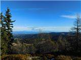
 | Bohinjsko sedlo - Šavnik (by Lajnar)
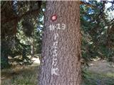
Šavnik is a grassy peak located between the Soriška planina and Kobla ski resorts. From the summit, which has a registration box with a stamp, yo...
2 h |
 | Furlanovo zavetišče pri Abramu - Vojkova koča na Nanosu
Vojkova koča is located on the southern edge of the Nanoše plateau, close to Pleše, a peak that is clearly visible from the motorway. From the hu...
2 h |
 | Dom na Smrekovcu - Komen
At 1684m, Komen is the highest peak of the Smrekov Mountains, a mountain range bordering Styria and Carinthia. From the top, in good weather, we ...
2 h |
 | Planina Vodol - Veliki Travnik
Veliki Travnik, or Turnovka as the locals call it, is located on the western edge of the Smrekov Mountains. From the top of the hill, where a woo...
2 h |
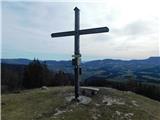
 | Predmeja - Kucelj na Čavnu (by road)
Kucelj is located on the southern slopes of Trnovo Forest, north-west of the Vipava valley. From the uncultivated summit on which the cross stand...
1 h 45 min |
 | Predmeja - Kucelj na Čavnu
Kucelj is located on the southern slopes of Trnovo Forest, north-west of the Vipava valley. From the uncultivated summit on which the cross stand...
2 h |
 | Krnica - Kucelj na Čavnu (via Veliki Rob)
Kucelj is located on the southern slopes of Trnovo Forest, north-west of the Vipava valley. From the uncultivated summit on which the cross stand...
1 h 40 min |
 | Škrbina - Mali Golak
Mali Golak is the highest of the Golaks. It was named not because it was the smallest but because it had the smallest mountain pasture. On the ma...
2 h |
 | Koča na Klopnem vrhu - Rogla
Rogla is the peak in the middle of the ski resort of the same name. The summit is woded with a small clearing on which stands a lookout tower. Th...
2 h 45 min |
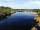 | Ribniška koča - Lovrenška jezera
Lovrenška jezera are located on a high mor in the middle of Pohorje between Rogla and Ribnica Pohorje. Smaller lakes, which receive water only fr...
2 h 5 min |
 | Sviščaki - Mali Snežnik
Mali Snežnik is a peak on the west ridge of Snežnika. Vrh, which is covered with dwarf pines, has a fine view of the neighbouring Veliki Snežnik ...
1 h 50 min |
 | Kampelc - Javornik above Črni vrh
Javornik is a forested peak located southeast of Črnji Vrho. In 1972, a lookout tower was erected on the summit, which reaches above the treetops...
2 h 15 min |
 | Repna dolina - Javornik above Črni vrh
Javornik is a forested peak located southeast of Črnji Vrho. In 1972, a lookout tower was erected on the summit, which reaches above the treetops...
1 h 45 min |
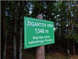 | Koča na Šumiku - Žigartov vrh
At 1346m, Žigartov vrh is the highest peak in the eastern part of Pohorje. An "observation" tower used to stand on the summit, but was erected on...
1 h 55 min |
 | Pohorje cable car - Žigartov vrh (via Razglednik)
At 1346m, Žigartov vrh is the highest peak in the eastern part of Pohorje. An "observation" tower used to stand on the summit, but was erected on...
2 h 15 min |
| Pohorje cable car - Žigartov vrh (via Mariborska koča)
At 1346m, Žigartov vrh is the highest peak in the eastern part of Pohorje. An "observation" tower used to stand on the summit, but was erected on...
2 h 20 min |
| Mariborska koča - Žigartov vrh
At 1346m, Žigartov vrh is the highest peak in the eastern part of Pohorje. An "observation" tower used to stand on the summit, but was erected on...
1 h 40 min |
 | Platak - Vidikovac
Vidikovac is a 1408m high peak in the Gorski Kotar. From the partially uncultivated summit there is a very nice view of the nearby Veliki Risnjak...
2 h 45 min |
 | Dom na Osankarici - Klopni vrh (eastern path)
Klopni vrh encloses the lower lying extensive plateau in the eastern Pohorje Mountains from the north-west. The area of the horizontal section at...
2 h 45 min |
| Koča na Šumiku - Klopni vrh (eastern path)
Klopni vrh encloses the lower lying extensive plateau in the eastern Pohorje Mountains from the north-west. The area of the horizontal section at...
2 h |
 | Koča na Šumiku - Klopni vrh (northern path)
Klopni vrh encloses the lower lying extensive plateau in the eastern Pohorje Mountains from the north-west. The area of the horizontal section at...
2 h |
 | Strma Reber - Cerk
At 1192 m, Cerk is the highest peak of Borovška Gora, a mountain range located between the Kolpa River valley and Goteniškje Snežnik. From the to...
1 h 45 min |
 | Solarji - Nagnoj
At 1193 m, Nagnoj is the second highest peak of the Kolovrat, a mountain range located between Tolmin and Venetian Slovenia. From the top, where ...
1 h 40 min |
 | Bohinjsko sedlo - Kačji rob (Ovharn)
Kačji rob is a 1520 m high peak located between mountain pasture Zgornji Jirn and the lesser known peak Žbanjek. The summit, which bears the Rati...
2 h |
| Soriška peč - Kačji rob (Ovharn)
Kačji rob is a 1520 m high peak located between mountain pasture Zgornji Jirn and the lesser known peak Žbanjek. The summit, which bears the Rati...
2 h 30 min |
 | Koča na Klopnem vrhu - Pesek
Pesek is a 1423 m high peak on Pohorje, located above Koča na Pesku....
2 h 23 min |
 | Koča na Šumiku - Veliki vrh (on Pohorje)
Veliki vrh is a 1344-metre-high peak located above the RTC Jakec - Trije kralji ski resort. The highest point of the peak is located in the fores...
2 h |
 | Teichalm (Teichalmsee) - Rote Wand (spodnja pot)
Rote Wand is a 1505 m high mountain in the Graz mountain range in Styria, Austria. It is named "Rote Wand" (red wall) after the southeast-facing ...
2 h 15 min |
| Teichalm (Teichalmsee) - Rote Wand (zgornja pot)
Rote Wand is a 1505 m high mountain in the Graz mountain range in Styria, Austria. It is named "Rote Wand" (red wall) after the southeast-facing ...
2 h 15 min |
 | Stoakoglhütte - Heulantsch
Heulantsch is a 1473m high grassy hill above the Teichalm, which together with the "Sommeralm" forms the largest area of mountain meadows in the ...
3 h |
| Sommeralm - Heulantsch
Heulantsch is a 1473m high grassy hill above the Teichalm, which together with the "Sommeralm" forms the largest area of mountain meadows in the ...
2 h 45 min |
 | Pfaffensattel - Grazer Stuhleck
...
2 h 15 min |
 | Feistritzsattel - Grabmayr-Kogel
...
1 h 40 min |
 | Planinski dom Orlove stine - Svilaja (mimo Umaca)
...
2 h |
 | Sommeralm - Osser
...
2 h |
 | Straßegg - Hochschlag
...
1 h 45 min |
 | Hebalm (Gasthaus Zur Rehbockhütte) - Barofen
...
2 h |
 | Weinebene Straße - Barofen
...
1 h 40 min |
| Gasthof Pfeifferstocker - Barofen
...
2 h |
 | Gasthof Pfeifferstocker - Renneiskogel
...
1 h 45 min |
 | Teichalm (Teichalmsee) - Gschaidberg (zgornja pot)
...
1 h 55 min |
| Teichalm (Teichalmsee) - Gschaidberg (mimo križa Gerlerkreuz)
...
1 h 55 min |