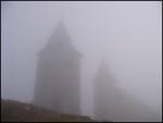
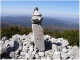
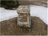
 | Kapetanova bajta - Snežnik
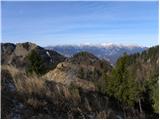
Snežnik or Veliki Snežnik is the highest peak in the near and far surroundings with a height of 1796 m. It offers a beautiful view over most of S...
55 min |
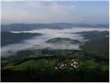
 | Lontovž - Kum (by road)
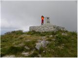
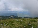
At 1220 metres, Kum is the highest peak of Posavsko hribovje. Because it rises above Zasavje, some people call it the Zasavje Triglav. On the sum...
50 min |
| Lontovž - Kum (footpath)
At 1220 metres, Kum is the highest peak of Posavsko hribovje. Because it rises above Zasavje, some people call it the Zasavje Triglav. On the sum...
40 min |
 | Vrh Bače - Možic
Možic is a 1602 m high peak located west of Soriška mountain pasture. It is at the highest point of the peak that there is an old military bunker...
1 h |
 | Vrh Bače - Kobla
The peak is located in the Lower Bohinj Mountains between Črna prst and Soriška mountain pasture. Just below the peak is a railway tunnel connect...
45 min |
 | Preval - Stari vrh
Stari vrh is a 1217 m high mountain located above the ski resort of the same name. There is no view from the summit itself due to the forest, but...
50 min |
 | Bohinjsko sedlo - Lajnar (marked way)
Lajnar is a 1549 m high mountain located north of Soriška mountain pasture. From the top, which is also the highest point of the ski resort, we h...
40 min |
 | Vrh Bače - Šavnik
Šavnik is a grassy peak located between the Soriška planina and Kobla ski resorts. From the summit, which has a registration box with a stamp, yo...
45 min |
 | Črni Kal - Koprivnik (bottom path)
Koprivnik is a 1393 m high mountain located between Blegoš and Mladi vrh. The view from the summit, which has a registration box and a stamp, is ...
1 h |
| Črni Kal - Koprivnik (via Romovec)
Koprivnik is a 1393 m high mountain located between Blegoš and Mladi vrh. The view from the summit, which has a registration box and a stamp, is ...
1 h |
 | Erjavčeva koča na Vršiču - Sovna glava (on old road)
Sovna glava is a 1750 m high grassy peak located between Prisank and the Vršič Alpine Pass. From the top, you have a beautiful view of the peaks ...
50 min |
 | Erjavčeva koča na Vršiču - Sovna glava (on footpath)
Sovna glava is a 1750 m high grassy peak located between Prisank and the Vršič Alpine Pass. From the top, you have a beautiful view of the peaks ...
45 min |
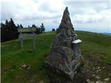 | Atelsko sedlo - Smrekovec
Smrekovec is a volcanic mountain on the eastern edge of the Smrekov Mountains. The extensive grassy summit, on which stands a pyramid with a regi...
50 min |
 | Hlipovec - Komen
At 1684m, Komen is the highest peak of the Smrekov Mountains, a mountain range bordering Styria and Carinthia. From the top, in good weather, we ...
50 min |
 | Hlipovec - Veliki Travnik
Veliki Travnik, or Turnovka as the locals call it, is located on the western edge of the Smrekov Mountains. From the top of the hill, where a woo...
45 min |
 | Preval Strgarija - Mali Golak
Mali Golak is the highest of the Golaks. It was named not because it was the smallest but because it had the smallest mountain pasture. On the ma...
45 min |
 | Snežniška Grda jama - Mali Snežnik
Mali Snežnik is a peak on the west ridge of Snežnika. Vrh, which is covered with dwarf pines, has a fine view of the neighbouring Veliki Snežnik ...
1 h |
 | Gate below Mali vrh - Uršlja gora (Plešivec) (by road)
Uršlja gora or Plešivec is a lookout mountain between Slovenj Gradec and Črna na Koroškem. On the top or just below it stands the Church of St Ur...
50 min |
 | Vrh Bače - Krevl
Krevl is a 1515 m high peak located to the south of the Kobla ski area, more precisely between Koble Peak and Kravje Črna Gora. From the summit, ...
1 h |
 | Koglereck - Huhnerkogel/Košenjak
Huhnerkogel lies north of Dravograd and the River Drava on the border with neighbouring Austria. Huhnerkogel is accessible on foot or by car from...
1 h |
 | Rifugio Pelizzo - Monte Mataiur/Matajur
Monte Mataiur is a scenic mountain located on the border between Slovenia and Itali. From the top, you have a beautiful view of the Kobarid or Br...
45 min |
 | Rifugio Pelizzo - Monte Mataiur/Matajur (via Dom na Matajure)
Monte Mataiur is a scenic mountain located on the border between Slovenia and Itali. From the top, you have a beautiful view of the Kobarid or Br...
55 min |
 | Prvine - Črni vrh (Čemšeniška planina)
Črni vrh is the highest peak of Čemšeniška mountain pasture and with a height of 1204 m it is the second highest peak in the Posavje - Zasavje hi...
1 h |
 | Tuškov Grič - Črni vrh above Novaki
Črni vrh, the highest point of the popular Cerkno ski centre, is located north-east of Novaky. From the summit, near which an artificial lake has...
45 min |
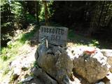 | Golte (Alpski vrt) - Boskovec (via Hleviška planina)
At 1587m, Boskovec is the highest peak of the Golta plateau. From the top of the lookout tower, you can see part of Kamnik Savinja Alps and the e...
1 h 5 min |
| Golte (Alpski vrt) - Boskovec (Severjeva pot)
At 1587m, Boskovec is the highest peak of the Golta plateau. From the top of the lookout tower, you can see part of Kamnik Savinja Alps and the e...
1 h |
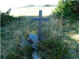
 | Krnica - Veliki Rob
Veliki Rob is a scenic peak located between Kuclje (1237m) and Čavno (1185m). From the summit on which the cross is located, there is a beautiful...
40 min |
 | Pečana - Gladki vrh (Ratitovec)
Gladki vrh is the most visited peak in the Ratitovec mountain range with an altitude of 1667 m. The uncultivated summit, on which the viewing pla...
50 min |
 | Pečana - Altemaver (Ratitovec)
Altemaver is the highest peak of Ratitovec at 1678 m. The grassy peak offers a beautiful view of Julian Alps, Jelovica, Karawanks, Kamnik Savinja...
55 min |
 | Kalce - Mali Javornik (Javorniki)
Mali Javornik is a 1219 m high mountain located in the crest of the forested Javorniki Ridge. There is no view from the top due to the forest, bu...
1 h |
 | Bohinjsko sedlo - Slatnik (southeastern peak) (via Lajnar)
Slatnik) is a scenic mountain that rises steeply above Baška Grapa on one side and descends more gently towards Soriška planina on the other side...
1 h 5 min |
| Bohinjsko sedlo - Slatnik (southeastern peak) (past barracks)
Slatnik) is a scenic mountain that rises steeply above Baška Grapa on one side and descends more gently towards Soriška planina on the other side...
1 h 10 min |
 | Teichalm (Parkirišče Heulantsch) - Heulantsch
Heulantsch is a 1473m high grassy hill above the Teichalm, which together with the "Sommeralm" forms the largest area of mountain meadows in the ...
45 min |
 | Feistritzsattel - Harterkogel
...
50 min |
 | Nechnitz - Gschaidberg
...
45 min |