 | Hrastovlje - Lačna
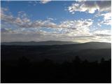
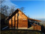
Lačna is a 451 m high hill located between Gračišče, Kubed and Hrastovlje. The top of the hill has a metal lookout tower, which offers a beautifu...
1 h 15 min |
 | Štore - Turn (Sv. Janez Krstnik) (via Kompole)
Turn is a peak above Štorá - Šentjanž nad Štorami. Slightly below the summit, on the site of the former Prežin Castle, the Church of St. John the...
1 h 15 min |
 | Hunting cottage Muljava - Mali Petrovac (Petrova gora) (via Mali Velebit)
Mali Petrovac is a rather low hill located somewhere on the border between Banja and Kordun, Pannonian Croatia and Gorski Kotar. The top is compl...
1 h 15 min |
 | Gorica pri Slivnici - Cerkev sv. Helene na Javorju
...
1 h 45 min |
 | Zagrad - Vipota (via crossing Ivankovič)
Vipota is a 532-metre-high peak south of Celje, above the left bank of the Savinja. Approaches to the summit are possible from several directions...
1 h 15 min |
 | Zgornje Poljčane - Ljubična gora
Ljubična gora is a hill located above Ljubično, Zbelovo and Zbelovo Gora. The hill is hidden in the forest and is not very visible, but the churc...
1 h 15 min |
 | Pliskovica - Volnik
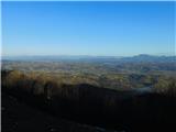
Volnik or Monte Lanaro in Italian is a 546 m high hill located near the village of Pliskovica in the Karst. It is topped by a small tower and off...
1 h 30 min |
 | Lopata - Planinski dom Šentjungert
The mountain lodge is located just a few metres below the top of Gora, on which the Church of St Kunigunde, built in the 14th century, stands. Th...
1 h 30 min |
 | Gorica pri Slivnici - Rifnik
Rifnik is a 568m high peak located south of Šentjur near Celje. The summit, which is famous for its archaeological site, offers a beautiful view ...
1 h 15 min |
 | Podčetrtek (Terme Olimia) - Zavetišče Šmarnica na Mali Rudnici (mimo gradu Podčetrtek)
...
1 h 15 min |
 | Olimje - Zavetišče Šmarnica na Mali Rudnici
...
1 h 45 min |
| Slake (cerkev Device Marije na Pesku) - Zavetišče Šmarnica na Mali Rudnici
...
1 h 35 min |
 | Dobrnič - Trebni vrh (via Šahovec)
Trebni vrh is a 581-metre-high hill located south or south-west of Trebnje. On the top of the forested hill there is a bench, and near it there i...
1 h 45 min |
 | Stogovci (Vabča vas) - Kerješetov vrh
Kerješetov vrh is a 590-metre-high hill located above Jelovice. The hill is covered with forest, and the view is second to none....
1 h 30 min |
 | Griže - Dragov dom na Homu (direct path)
Drago's home is located on a scenic hill, south of Šempeter. From the top, which is also the Church of St. Magdalene, there is a beautiful view f...
1 h 30 min |
| Griže - Dragov dom na Homu (via Zahom)
Drago's home is located on a scenic hill, south of Šempeter. From the top, which is also the Church of St. Magdalene, there is a beautiful view f...
1 h 50 min |
| Griže - Dragov dom na Homu (via Lajnarjev hrib)
Drago's home is located on a scenic hill, south of Šempeter. From the top, which is also the Church of St. Magdalene, there is a beautiful view f...
1 h 40 min |
| Šešče pri Preboldu - Dragov dom na Homu (Brdovska pot)
Drago's home is located on a scenic hill, south of Šempeter. From the top, which is also the Church of St. Magdalene, there is a beautiful view f...
1 h 15 min |
 | Za koridorjem - Sabotin (on ridge)
Sabotin is hill above Nova Gorica or more accurate above Solkan. Altough its low attitude it is great outlook with sight to Julian Alps, river So...
1 h 15 min |
 | Bad Gleichenberg (Sägewerk Weiss) - Stradner Kogel
Stradner Kogel is the highest hill in south-eastern Styria. The hill is of volcanic origin, and its vegetation prevents views in any direction. O...
1 h 15 min |
 | Zgornje Poljčane - Rančka
...
1 h 25 min |
 | Podčetrtek (sveti Lovrenc) - Silavec (Stolp zdravja in veselja na Rudnici) (mimo gradu Podčetrtek)
...
1 h 25 min |
| Podčetrtek (sveti Lovrenc) - Silavec (Stolp zdravja in veselja na Rudnici) (lažja pot)
...
1 h 15 min |
| Podčetrtek (sveti Lovrenc) - Silavec (Stolp zdravja in veselja na Rudnici) (težja pot)
...
1 h 15 min |
| Spodnje Tinsko - Silavec (Stolp zdravja in veselja na Rudnici)
...
1 h 20 min |
| Olimje - Silavec (Stolp zdravja in veselja na Rudnici) (mimo Koče pri čarovnici)
...
1 h 45 min |
| Olimje - Silavec (Stolp zdravja in veselja na Rudnici) (težja pot)
...
1 h 35 min |
| Olimje - Silavec (Stolp zdravja in veselja na Rudnici) (lažja pot)
...
1 h 35 min |
| Slake (cerkev Device Marije na Pesku) - Silavec (Stolp zdravja in veselja na Rudnici) (težja pot)
...
1 h 25 min |
| Slake (cerkev Device Marije na Pesku) - Silavec (Stolp zdravja in veselja na Rudnici) (lažja pot)
...
1 h 25 min |
 | Naraplje - Jelovice
Jelovice with a height of 623 metres - the highest peak of the Haloze hills. The summit is accessible from several directions. It is partially vi...
1 h 40 min |
| Stogovci (Vabča vas) - Jelovice
Jelovice with a height of 623 metres - the highest peak of the Haloze hills. The summit is accessible from several directions. It is partially vi...
1 h 40 min |
 | Grgar - Frančiškov hrib
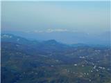
Frančiškov hrib is a less prominent peak located on Skalnica, whose highest peak is the 681-metre Sveta Gora. From the lookout peak, on which the...
1 h 15 min |
 | Kozje - Raskože (Bohor) (via Vetrnik)
Raskože is a 650-metre-high peak in the eastern part of Bohor. Some also call this area Vetrnik. The south side of the peak is dominated by fores...
1 h 15 min |
 | Grgar - Vodice (via Ranjeke)
Vodice (according to some records also Sv. Jakob) is a peak located in the western part of the Banjška plateau. The summit, on which the mausoleu...
1 h 30 min |