 | Gorenje - Gora (Sveti Lovrenc) (gentle path)
Gora, or Sveti Lovrenc, is a peak above Studeni. It is a village north of Postojna, which is also a good starting point for climbing to the top o...
1 h 45 min |
 | Jablance - Skalica (Bohor) (via Travni laz)
Skalica is a less known peak in the western part of Bohor. From the summit, which has a registration box, there is a beautiful view to the south ...
2 h |
 | Bač - Kršičevec
Kršičevec is a lesser known mountain located east of the village Jurišče in the Pivka Basin. From the grassy summit, where there is a registratio...
2 h 15 min |
 | Selca - Miklavška gora (by road)
Miklavška gora is a lookout located south of Železniki and Selce. From the top of the hill on which the Church of St Nicholas stands, we have a b...
1 h 45 min |
 | Begunje (Krpin) - Smokuški vrh (on cart track and past sv. Peter)
Smokuški vrh is a scenic mountain located on a ridge between the Završnice valley and the Gorenjska plain. From the top of the hill, where there ...
1 h 50 min |
 | Rodine - Smokuški vrh (via Sankaška koča)
Smokuški vrh is a scenic mountain located on a ridge between the Završnice valley and the Gorenjska plain. From the top of the hill, where there ...
1 h 45 min |
 | Hunting lodge below Glavica - Grmada at Slavnik
Grmada is a 998m high peak located northwest of Slavnik. From the top of the peak, where the fire safety observatory is located, you can enjoy a ...
2 h 20 min |
 | Razdrto - Grmada (Nanos)
Grmada is a 1209 m high peak located to the north-west of the better known Plesa. From the summit, where there is a registration box with a stamp...
2 h 5 min |
 | Podmeja - Javor
Javor is a 1132 m high peak located between Kisovec and Sveta mountain pasture. There is no view from the top, which is covered with forest, but ...
2 h |
 | Dom pod Reško planino - Javor
Javor is a 1132 m high peak located between Kisovec and Sveta mountain pasture. There is no view from the top, which is covered with forest, but ...
2 h 5 min |
 | Kokra (resting place Kokra-sotočje) - Kopa (Partizanski vrh)
Kopa, also Partizanski vrh, is a 1024-metre high mountain located west of the Davovec saddle, which is west to south-west of Krvavec. There is a ...
1 h 45 min |
 | Bottom station of cableway on Krvavec - Skutman (via Kopa)
Skutman is a lesser-known peak located above the left bank of the Kokra River and north of Štefanje Gora. The summit is marked by a metal sign wi...
1 h 45 min |
| Spodnja Kokra - Skutman (via Kopa)
Skutman is a lesser-known peak located above the left bank of the Kokra River and north of Štefanje Gora. The summit is marked by a metal sign wi...
2 h |
 | Poljšica pri Gorjah (Zatrata) - Hotunjski vrh (by road)
Hotunjski vrh is a 1107-metre-high lookout peak located above the Zatrnik ski resort. From the top, where there is a registration box and a bench...
2 h |
| Bled (Velika Zaka) - Hotunjski vrh
Hotunjski vrh is a 1107-metre-high lookout peak located above the Zatrnik ski resort. From the top, where there is a registration box and a bench...
2 h 30 min |
 | Poljana - Andrejev vrh (over Volinjak and on cart track)
Andrejev vrh is a forested peak located between Mežica and Lesa. There is a bench on the top and a registration box with a registration book....
1 h 50 min |
| Poljana - Andrejev vrh (via Volinjak and past the chapel)
Andrejev vrh is a forested peak located between Mežica and Lesa. There is a bench on the top and a registration box with a registration book....
1 h 55 min |
| Poljana - Andrejev vrh (past Leše churches and on cart track)
Andrejev vrh is a forested peak located between Mežica and Lesa. There is a bench on the top and a registration box with a registration book....
1 h 50 min |
| Poljana - Andrejev vrh (via Leše churches and via chapel)
Andrejev vrh is a forested peak located between Mežica and Lesa. There is a bench on the top and a registration box with a registration book....
1 h 55 min |
 | Nemilje - Sleme (Površnica) (via Prevoje)
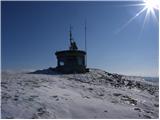
Sleme is a scenic peak located between Rudni, Dražgoše and Lajša. The summit, where the transmitters are located, offers a beautiful view of the ...
2 h 5 min |
 | Nemilje - Sveti Križ above Selca (via Prevoje)
The Sveti Križ above Selca church is situated on a lookout point, which offers a beautiful view over part of the Škofjeloško hribovje....
2 h 25 min |
 | Njivica - Bela peč (Podbliška gora)
Bela peč is located on the edge of Jelovica above the village of Podblica. From the top of the cliff we have a beautiful view of the village, the...
2 h 35 min |
 | Kropa (Slovenska peč) - Bela peč (Podbliška gora) (via tehnika Meta)
Bela peč is located on the edge of Jelovica above the village of Podblica. From the top of the cliff we have a beautiful view of the village, the...
3 h |
 | Libeliče - Šteharski vrh (Šteharnikov vrh) (via Trotov križ)
Šteharski or Šteharnikov vrh, also Črneška gora, is a 1018-metre-high mountain located in the south-eastern part of Strojna, a mountain range bet...
3 h |
 | Črna na Koroškem (Mušenik) - Pikov vrh (via Koča na Pikovem)
Pikov vrh is a 1149 m high peak located above Podpeca, more precisely above the Pik homestead, near the Koča na Pikovem. On the top there is a re...
1 h 45 min |
 | Črna na Koroškem (Mušenik) - Veliki vrh (above Mežiška dolina) (via Šumahovo sedlo)
Veliki vrh is a 1165-metre-high peak located between Mežica and Črna na Koroškem. On the summit, there is a registration box with a registration ...
1 h 45 min |
 | Črna na Koroškem (Mušenik) - Šumahov vrh (via Šumahovo sedlo)
Šumahov vrh is a 1155-metre-high peak on which a wooden cross is erected. From the top, which descends steeply towards Žerjav, we have a beautifu...
1 h 45 min |
 | Libeliče - Pokeržnikov vrh
Pokeržnikov vrh is a 1,055-metre-high peak located above the village of Strojna in the municipality of Ravne na Koroškem. From the top, where the...
2 h 15 min |
 | Libeliče - Šteknetov vrh (via Trotov križ)
Šteknetov vrh, also marked as Štekneči vrh on some maps, is a 1061 m high peak located between Požegovi vrh and Šteharski vrh. On the top, which ...
2 h 20 min |
 | Rodine - Pleče (via Sankaška koča)
Pleče is a 1131-metre-high peak located north of St Peter above Begunje. The summit is covered by forest, but from near the top, we can enjoy som...
1 h 50 min |
| Begunje (Krpin) - Pleče (by ski slope and via Sankaška koča)
Pleče is a 1131-metre-high peak located north of St Peter above Begunje. The summit is covered by forest, but from near the top, we can enjoy som...
1 h 45 min |
| Begunje (PGD Begunje) - Pleče (Petrova pot)
Pleče is a 1131-metre-high peak located north of St Peter above Begunje. The summit is covered by forest, but from near the top, we can enjoy som...
1 h 45 min |
| Begunje (Krpin) - Pleče (through Blatnica Gorge)
Pleče is a 1131-metre-high peak located north of St Peter above Begunje. The summit is covered by forest, but from near the top, we can enjoy som...
1 h 45 min |
 | Grahovo ob Bači (Brelih) - Črvov vrh (via Žrelo)
Črvov vrh, also known as Črvov grič, is the highest peak of the Šentviška plateau, rising above the right bank of the Idrijca and the left bank o...
1 h 50 min |
 | Žiri - Krog (Ledinski grič)
Krog is a 940 m high peak located on the western part of the Ledinski grič ridge, which is situated between the Jerešča and Ledinščica watercours...
1 h 50 min |
| Sovodenj - Krog (Ledinski grič)
Krog is a 940 m high peak located on the western part of the Ledinski grič ridge, which is situated between the Jerešča and Ledinščica watercours...
2 h 5 min |
 | Podgora - Špik (Vranškov grič)
Špik, also known as Vranškov grič on maps, is a 908 m high mountain located west of Hotavlje. The peak is located in a forest, but the grassy for...
1 h 45 min |
 | Hotavlje - Kucelj (above Kopačnica) (via village Studor)
Kucelj is a 920-metre-high peak located above the left bank of the Kopačnica and above the village of the same name. On the top there is a bench,...
2 h 10 min |
| Hotavlje - Kucelj (above Kopačnica) (via Srednje Brdo)
Kucelj is a 920-metre-high peak located above the left bank of the Kopačnica and above the village of the same name. On the top there is a bench,...
1 h 55 min |
 | Schrems/Frohnleiten (Hautabauer) - Harterberg (Hoaterberg)
...
2 h |
 | Mixnitz (Parkirišče Bärenschützklamm) - Rannerwandkreuz
...
1 h 45 min |