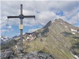
 | Dom pod Storžičem - Storžič (via Škarjev rob)
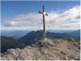
Storžič is a 2132 m high mountain located in the western part of the Kamink Savinja Alps. From the top with a cross there are beautiful views of ...
3 h |
 | Pod Krnico - Koschutnikturm (Košutnikov turn) (western way)
Košutna Turn is the highest peak in Slovenia's longest ridge, the Košuta. From the top, you have a beautiful view of the entire ridge. Austria an...
2 h 15 min |
| Pod Krnico - Koschutnikturm (Košutnikov turn) (eastern way)
Košutna Turn is the highest peak in Slovenia's longest ridge, the Košuta. From the top, you have a beautiful view of the entire ridge. Austria an...
2 h 30 min |
 | Planina Zapleč - Srednji vrh (at Krn)
...
3 h 10 min |
 | Planina Zapleč - Krnčica
Krnčica is a peak in the undulating ridge that stretches from Bovec to Krno. In fact, it is the north-western ridge of Krnov. It is easily access...
2 h 40 min |
 | Iličev rovt / Illitsch Rauth - Mittagskogel/Kepa (path 680)
Kepa, also Jepa, or Mittagskogel in German, is a scenic mountain in the western Karawanks, located on the border ridge between Slovenia and Austr...
3 h |
 | Sella Nevea - Monte Bila pec
White oven, or Italian. Monte Bila pec is a 2146 m high mountain located to the north of the main Kanin ridge. From the top, where there is a reg...
2 h 45 min |
 | Plockenpass - Monte Floriz
Monte Floriz is a 2184m high grassy peak located south of the Marinelli hut. From the summit there is a very fine view of the Coglians group, and...
3 h |
 | Dom v Tamarju - Srednja Ponca / Ponza di Mezze
Srednja Ponca is a 2228m high peak rising steeply above Tamar, Planica and the Mangart valley. From the summit on which the stamp is located, the...
3 h 15 min |
 | Fiames - Punta Fiames
Punta Fiames is a 2240-metre peak located north of Cortina d'Ampezzo. The mountain is particularly popular among those who like protected climbin...
3 h 30 min |
 | Cima Sappada - Creton di Tul
Creton di Tul is a 2288 meter high mountain in a mountain group Pesarina Dolomites in the Carnic Alps in Italy, south of a city of Sappada and ju...
3 h 30 min |
 | Planina Podvežak - Ojstrica (via Mala Ojstrica)
Ojstrica, named after its sharp shape, rises steeply above the Korošica River, the Logar Valley and Robanov Kot. From the top, where the registra...
3 h 30 min |
| Kraljev dol - Ojstrica (via Mala Ojstrica)
Ojstrica, named after its sharp shape, rises steeply above the Korošica River, the Logar Valley and Robanov Kot. From the top, where the registra...
3 h 45 min |
 | Jochalm - Reißkofel (235-1)
Reißkofel is a 2371 metre high mountain in the Zilj Alps. The summit on which the cross stands also has a registration box. The view from the top...
3 h |
 | Jochalm - Reißkofel (path 235)
Reißkofel is a 2371 metre high mountain in the Zilj Alps. The summit on which the cross stands also has a registration box. The view from the top...
3 h 25 min |
 | Bergheimat - Dachskofel (via Scharnik)
Dachskofel is a 2373m high mountain in Hohe Tauern in Austria above the city of Irschen and near the Lamnitzsee. A wooden cross is placed on the ...
3 h 50 min |
 | Passo di Sant'Antonio - Monte Aiarnola (via normale)
Monte Aiarnola is a mountain in the easternmost part of the Sexten Dolomites group. It offers a fine view of the western Carnic Alps, the Marmaro...
3 h 30 min |
 | Sella di Razzo - Clapsavon (via 210 & 212)
Clapsavon is a 2462 m high mountain in Carnic Alps in Italy, and it is situated just short of 1 hour hiking distance to the west from Monte Biver...
3 h |
 | Göriach - Scharnock
Scharnock is a scenic peak located in the Schladminger Tauern mountain group. From the summit on which the cross stands, there is a beautiful vie...
3 h 30 min |
 | Sella Nevea - Prestreljenik (via 636)
Prestreljenik is a 2499 m high mountain located in the heart of the Kanin Mountains. From the top, where the Aljaž Tower-shaped registration box ...
3 h 45 min |
 | Saddle Sedlo - Bobotov kuk
Bobotov kuk is the highest peak of Durmitor. It is the highest peak of the XXXXXX range. The southern approaches are the shortest and the eastern...
3 h |
 | Dolina Dobri do - Bobotov kuk
Bobotov kuk is the highest peak of Durmitor. It is the highest peak of the XXXXXX range. The southern approaches are the shortest and the eastern...
2 h 45 min |
 | Vršič - Prisank / Prisojnik (Slovenian way)
Prisank is a 2547 m high mountain located above the valleys of Mlinarica, Krnica and Suha Pišnica. From the top of the peak, where the registrati...
3 h 30 min |
| Erjavčeva koča na Vršiču - Prisank / Prisojnik (Slovenska pot)
Prisank is a 2547 m high mountain located above the valleys of Mlinarica, Krnica and Suha Pišnica. From the top of the peak, where the registrati...
3 h 45 min |
 | Gschnitz - Kalkwand (zahodni pristop iz Gschnitza preko Pinnisjocha)
Kalkwand is a large mountain in the eastern part of the Habicht group of the central Stubai Alps. Thanks to its attractive views, the low difficu...
3 h 45 min |
 | Oberissalm - Vordere Sommerwand (normal path)
The Sommerwand is a relatively long ridge rising like a mighty rock barrier above the upper part of the Oberbergtal valley, hiding from the valle...
2 h 40 min |
 | Rifugio Pederü - Croda del Beco / Seekofel
Croda del Beco (German: Seekofel, Ladin: Sass dla Porta) is a 2,810-metre-high mountain rising steeply above Lago di Braies (Pragser Wildsee). It...
3 h 45 min |
| Rifugio Ra Stua - Croda del Beco / Seekofel
Croda del Beco (German: Seekofel, Ladin: Sass dla Porta) is a 2,810-metre-high mountain rising steeply above Lago di Braies (Pragser Wildsee). It...
3 h 35 min |
 | Ristorante Pietofana - Cima Formenton
Cima Formenton is a 2830 m high peak in the Tofana mountain group. The mountain is located to the north of the better known Tofana di Dentro, and...
3 h 40 min |
 | Passo Gardena - Cima Pisciadu (path 666)
Cima Pisciadu or Pisciadu Spitze is a 2985 metre high peak in the Sella mountain group. The mountain is located in the northern part of the group...
3 h 40 min |
 | Oberissalm - Rinnenspitze (običajni pristop mimo Franz-Senn-Hütte)
Rinnerspitze is a beautiful conical mountain rising above the lake of the same name. Although it does not stand out for its height or the difficu...
3 h 45 min |