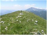
 | Volovljek - Kranjska reber (on unmarked path)
Kranjska reber or Peak Kašna planina (1435 m) is a volcanic mountain. From the top, where the registration box with the stamp is located, we have...
1 h 15 min |
 | Bohinjsko sedlo - Slatnik (northwestern peak) (by Lajnar)
Slatnik is a scenic mountain located to the west of the Soriška mountain pasture ski resort. The grassy peak offers a beautiful view of the Škofj...
1 h 15 min |
 | Planina Vetrh - Bela peč (via cottage Pr Zdravc)
The mountain, which is known mainly by climbers, is located north of Storžič on the slopes of Konjščice. From the top there is a beautiful view o...
1 h 15 min |
 | Dom na Smrekovcu - Krnes (via Smrekovec)
The summit is located in the heart of the Smrekov Mountains and has a beautiful view. Peca, Uršlja gora and part of the highest peaks of the Savi...
1 h 35 min |
 | Kozarnice - Srednji Golak (unmarked eastern way)
Srednji Golak is located between Mali and Veliki Golak on the plateau of the Trnovo Forest above Predmeja. The summit is covered with dwarf pines...
1 h 45 min |
 | Planina Smrečica (Poglajnov rovt) - Galetovec
Galetovec is an undistinguished peak in the south-eastern part of the Pokljuka plateau. From the summit, which has a registration box, there is a...
2 h |
 | Dom Pristava in Javorniški Rovt - Španov vrh
Španov vrh is a 1334m high mountain located between Javorniški Rovt and Mountain pasture below Golica. From the top, reached by the cable car of ...
1 h 30 min |
| Planina pod Golico - Španov vrh
Španov vrh is a 1334m high mountain located between Javorniški Rovt and Mountain pasture below Golica. From the top, reached by the cable car of ...
1 h 15 min |
 | Planina Lom - Kobilja glava
Kobilja glava is a 1475 m high peak located east of Tolmin. From the top with a cross, we have a beautiful view of the Krn, the Lower Bohinj Moun...
1 h 15 min |
 | Planina Lom - Jalovnik
Jalovnik is a grassy peak located southeast of the slightly higher Kobilje glave. From the summit, which has a registration box, we have a beauti...
1 h 30 min |
 | Koča na Gozdu - Visoki Mavrinc
Visoki Mavrinc (Špica v Sedelcih) is a 1562 m high mountain located between Suha, Mala and Velika Pišnica. From the top of the peak, where there ...
1 h 15 min |
 | Križovec - Mala Golica
Mala Golica is a less distinct peak located east of Krvavka. From the grassy peak, we have a beautiful view of the Drava Valley, Barentaler Kotsc...
1 h 30 min |
 | Planina Loka - Kup (on Raduha)
Jelovec is a 1808 m high peak located at the extreme north-eastern part of Raduha. From the top, on which the cross stands, we have a beautiful v...
1 h 20 min |
 | Rotek - Erbelc
Erbelc is a 1308-metre-high peak rising steeply above Zgornja Sorica. From the summit, where the registration box is located, you can enjoy a bea...
1 h 15 min |
 | Rotek - Tonderškofel
Tonderškofel is a 1326-metre high peak located between Soriška Peć and Erbellec. The partly overgrown peak, which has no marked trail, offers a b...
1 h 15 min |
 | Tolminske Ravne - Javor (above Tolminske Ravne)
Javor is a 1363 m high peak located between Tolminske Ravne and Grušnica. From the top, on which a small cross is erected, you can enjoy a beauti...
1 h 20 min |
 | Polja - Kališje
Kališje is a lesser-known peak in the western part of the Karavanke Mountains. From the summit, where the transmitters are located, we have some ...
1 h 40 min |
 | Planina Smrečica (Poglajnov rovt) - Turn (above Bohinjska Bela)
Turn is a scenic and precipitous peak located above Bohinjska Bela. From the top you can enjoy a beautiful view of Ratitovec, Jelovica, Kamnik Sa...
1 h 40 min |
 | Topla (Končnik) - Šoparjev vrh
Šoparjev vrh is a 1524 m high mountain located between Olševa and Peca, more precisely on the ridge that separates the Koprivna valley from the T...
1 h 15 min |
| Pod Peco / Koprein-Petzen - Šoparjev vrh
Šoparjev vrh is a 1524 m high mountain located between Olševa and Peca, more precisely on the ridge that separates the Koprivna valley from the T...
1 h 35 min |
 | Poden / Bodental - Veliki Rob / Großer Rain
Veliki Rob is a 1464 m high peak located on the Austrian side of Karawanks, in the ridge above the Poden / Bodental valley. The summit has been o...
1 h 50 min |
 | Poden / Bodental - Veronjak / Hausberg
Veronjak is a 1348 m high peak located above the Poden / Bodental valley on the Austrian side of the Karavanke. From the top, where there is a sm...
1 h 20 min |
| Slovenji Plajberk / Windisch Bleiberg - Veronjak / Hausberg (via Veronjak / Hausberg)
Veronjak is a 1348 m high peak located above the Poden / Bodental valley on the Austrian side of the Karavanke. From the top, where there is a sm...
1 h 25 min |
 | Erjavčev rovt - Bela peč (above Dovje)
Bele peči is a less known peak, located above the marked Dovje - Dovška Baba trail. The summit offers a beautiful view to the south and west, whi...
1 h 15 min |
 | Teichalm (Teichalmsee) - Zachenkreuz
Zachenkreuz is a 1601 m high peak located above the mountain pasture Teichalm. A wooden cross stands on the summit, which is mostly covered by a ...
1 h 20 min |
| Breitalm - Zachenkreuz
Zachenkreuz is a 1601 m high peak located above the mountain pasture Teichalm. A wooden cross stands on the summit, which is mostly covered by a ...
1 h 15 min |
 | Pension Camping Holzmeister - Plankogel (via Kerscbaumalm)
...
1 h 50 min |
 | Teichalm (Harrerhütte) - Bründlkogel
...
2 h 10 min |
 | Pension Camping Holzmeister - Zechnerschlag (Rohregg)
...
1 h 30 min |
 | Straßegg - Zechnerschlag (Rohregg)
...
1 h 30 min |
 | Dražgoše (Jelenšče) - Britmanca (gentle path)
...
1 h 15 min |
 | Bürgeralm (Panoramastraße) - Hochstein (at Mitteralm) (via Windgrube)
...
1 h 25 min |