 | Potoče - Javorov vrh (via Sveti Jakob, below Potoška gora and over Baba)
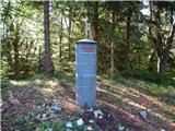
Javorov vrh (also Javorjev vrh according to some records) is a 1434 m high mountain located northeast of Preddvor. From the top, which has a regi...
2 h 55 min |
| Spodnja Kokra - Javorov vrh (via Baba)
Javorov vrh (also Javorjev vrh according to some records) is a 1434 m high mountain located northeast of Preddvor. From the top, which has a regi...
2 h 30 min |
 | Razdrto - Vojkova koča na Nanosu (Janez way)
Vojkova koča is located on the southern edge of the Nanoše plateau, close to Pleše, a peak that is clearly visible from the motorway. From the hu...
2 h |
 | Selski most - Babji zob
Babji zob is a lookout point above the village of Kupljenik near Bled. The precipitous peak, which has a registration box, has a beautiful view o...
2 h 30 min |
 | Vitovlje - Čaven
Čaven is a forested peak located west of Veliki Rob (1237m). The peak, which has a very well-known name, is not reached by any marked trail, alth...
2 h 30 min |
| Vitovlje - Čaven (via Vitovlje Lake)
Čaven is a forested peak located west of Veliki Rob (1237m). The peak, which has a very well-known name, is not reached by any marked trail, alth...
2 h 40 min |
 | Jesenice (Straža) - Španov vrh (via Jelenkamen)
Španov vrh is a 1334m high mountain located between Javorniški Rovt and Mountain pasture below Golica. From the top, reached by the cable car of ...
2 h 30 min |
 | Potoče - Baba (via sv. Jakob and source below Potoška gora)
Baba is a 1119 m high peak located to the west of Čemšenik. From the summit, where the registration box is located, you can enjoy a beautiful vie...
2 h 10 min |
 | Razdrto - Grmada (Nanos)
Grmada is a 1209 m high peak located to the north-west of the better known Plesa. From the summit, where there is a registration box with a stamp...
2 h 5 min |
 | Radlje ob Dravi - Kapunar / Kapunerkogel (on unmarked path)
Kapunar is a 1051 m high peak above Radlje ob Dravi. Just below the peak is an old caravan and border guardhouse, which is now used by radio amat...
2 h 15 min |
 | Vitanje - Stenica (via valley of the stream Jez)
Stenica is a 1091 m high peak located between Vitanje, Stranice and Frankolovi. There is no view from the top, which has a stamp with a registrat...
1 h 50 min |
 | Loke - Javor
Javor is a 1132 m high peak located between Kisovec and Sveta mountain pasture. There is no view from the top, which is covered with forest, but ...
2 h 25 min |
 | Bled (Velika Zaka) - Hotunjski vrh
Hotunjski vrh is a 1107-metre-high lookout peak located above the Zatrnik ski resort. From the top, where there is a registration box and a bench...
2 h 30 min |
| Bohinjska Bela (St. Marjeta) - Hotunjski vrh
Hotunjski vrh is a 1107-metre-high lookout peak located above the Zatrnik ski resort. From the top, where there is a registration box and a bench...
2 h 15 min |
 | Njivica - Bela peč (Podbliška gora)
Bela peč is located on the edge of Jelovica above the village of Podblica. From the top of the cliff we have a beautiful view of the village, the...
2 h 35 min |
| Nemilje - Bela peč (Podbliška gora) (via Sleme)
Bela peč is located on the edge of Jelovica above the village of Podblica. From the top of the cliff we have a beautiful view of the village, the...
2 h 25 min |
 | Leše - Hom (above Prevalje) (via Kot pri Prevaljah)
Hom is a 1193 m high peak located between Uršlja gora and Prevalje. On the top there is a registration box with a registration book, but the view...
2 h 40 min |
 | Mežica - Jesenik (Jesenikov vrh) (via saddle Vrh šteng)
Jesenik is a 1199 m high forested peak located between Mežica and Podpec....
2 h |
 | Mežica - Jesenik (Jesenikov vrh) (via homestead Jesenik)
Jesenik is a 1199 m high forested peak located between Mežica and Podpec....
2 h 5 min |
 | Mežica - Pikov vrh (via homestead Jesenik)
Pikov vrh is a 1149 m high peak located above Podpeca, more precisely above the Pik homestead, near the Koča na Pikovem. On the top there is a re...
2 h |
| Črna na Koroškem (Mušenik) - Pikov vrh (via Šumahovo sedlo)
Pikov vrh is a 1149 m high peak located above Podpeca, more precisely above the Pik homestead, near the Koča na Pikovem. On the top there is a re...
2 h 25 min |
 | Mežica - Veliki vrh (above Mežiška dolina) (via Pikov vrh)
Veliki vrh is a 1165-metre-high peak located between Mežica and Črna na Koroškem. On the summit, there is a registration box with a registration ...
2 h 40 min |
| Črna na Koroškem (Mušenik) - Veliki vrh (above Mežiška dolina) (via Koča na Pikovem)
Veliki vrh is a 1165-metre-high peak located between Mežica and Črna na Koroškem. On the summit, there is a registration box with a registration ...
2 h 25 min |
 | Libeliče - Šteknetov vrh (via Trotov križ)
Šteknetov vrh, also marked as Štekneči vrh on some maps, is a 1061 m high peak located between Požegovi vrh and Šteharski vrh. On the top, which ...
2 h 20 min |
 | Tržič (Čegelše) - Robič (via Zavetišče na Kalu)
Robič is a 1384 m high peak located between the valley of Tržiška Bistrica and the ridge of Košuta. The summit offers a beautiful view, especiall...
2 h 55 min |
 | Činžat - Lamprehtov vrh
Lamprehtov vrh is a 1230 m high peak on Pohorje, located north-east of Klopni vrh....
2 h 30 min |
 | Mixnitz (Parkirišče Bärenschützklamm) - Rannerwandkreuz
...
1 h 45 min |
 | Mixnitz (Parkirišče Bärenschützklamm) - Ranerwand
...
2 h 30 min |