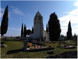
 | Juršinci - Gomila
Gomila is a 352-metre-high peak in the Slovenske gorice mountains, located between Ptuj and Ljutomer. From the top of the peak, which has an 18-m...
1 h 15 min |
 | Ženavlje (memorial plaque) - Church of the Holy Trinity (Gornji Petrovci)
The Church of the Holy Trinity is located on a hill in Gornji Petrovci. From the top, you have a beautiful view of Goričko....
1 h 20 min |
 | Selo (log cabin TIC Selo) - Sveti Benedikt (Kančevci)
The Church of St Benedict is situated on a 358-metre-high hill at the end of the village of Kančevci. Next to the church there is the Benedict Ho...
1 h 30 min |
 | Lenart v Slovenskih goricah - Zavrh v Slovenskih goricah (via lake Radehova)
Zavrh is a village in the Slovenian Highlands, known to mountaineers mainly as a point on the extended Slovenian mountain trail. In the centre of...
1 h 20 min |
 | Komare doline - Sveti Kvirik
The church or chapel of St.Kvirik (on maps and elsewhere we can also find names such as St.Kirk, Kirik, Kvirk, Kvirin, Kirin) is located on the l...
1 h 20 min |
 | Nuskova - Serdiški breg (Rdeči breg)
Serdiškis, or Red Bank, is a 416 m high hill located near the border with Austria. The grassy hill, with a few benches and a wooden log cabin, of...
50 min |
| Nuskova - Serdiški breg (Rdeči breg) (via Brunarjev breg)
Serdiškis, or Red Bank, is a 416 m high hill located near the border with Austria. The grassy hill, with a few benches and a wooden log cabin, of...
1 h |
| Serdica - Serdiški breg (Rdeči breg) (via Brunarjev breg)
Serdiškis, or Red Bank, is a 416 m high hill located near the border with Austria. The grassy hill, with a few benches and a wooden log cabin, of...
50 min |
 | Dolena (Stojana vas) - Janški vrh
Janški vrh is a 417m high peak on which stands a small village of the same name and the 15th century church of St John the Baptist. The place is ...
50 min |
| Naraplje - Janški vrh
Janški vrh is a 417m high peak on which stands a small village of the same name and the 15th century church of St John the Baptist. The place is ...
1 h 30 min |
 | Sotina - Sotinski breg (Kugla) (via the source of mineral water)
Sotinski breg or Kugla is the highest peak in Prekmurje at 418 m. From the top, which has a wooden lookout tower with a bell and a cross on it, y...
50 min |
 | Pernica - Vavtošek
...
1 h 5 min |
 | Lokvica - Fajti hrib
Fajti, according to some records also Fajti hrib, is a 433 m high peak located in the ridge of the Black Hills. The summit, which is known mainly...
1 h |
 | Vojnik - Sveti Tomaž above Vojnik
St.Thomas is a church standing on a partially vegetated 444 m high peak near Vojnik. On the top there is a registration book with a stamp. Below ...
1 h |
 | Ljubljana (Gruberjeva brv) - Mazovnik (Golovec)
At 450 m, Mazovnik is the highest peak of Golovec, a hill located in the south-eastern part of Ljubljana. Golovec was unforested until the end of...
1 h |
 | Ljubljana (Žabja vas) - Orle
Orle is a locality in the municipality of Lavrica, located on a small hill northeast of the Ljubljana Mor. A few metres below the highest point o...
1 h 15 min |
| Ljubljana (Sveti Urh) - Orle
Orle is a locality in the municipality of Lavrica, located on a small hill northeast of the Ljubljana Mor. A few metres below the highest point o...
1 h 10 min |
 | Stainz bei Straden - Rosenberg
...
1 h 10 min |
 | Suhadole - Koseški hrib (via Mlinčki)
Koseški hrib is located between Kuharjevi boršt' and Kosezami, the settlement after which the peak is named. From the top, where there is a table...
50 min |
| Bukovica pri Vodicah - Koseški hrib (via Mlinčki)
Koseški hrib is located between Kuharjevi boršt' and Kosezami, the settlement after which the peak is named. From the top, where there is a table...
50 min |
 | Topole - Koseški hrib
Koseški hrib is located between Kuharjevi boršt' and Kosezami, the settlement after which the peak is named. From the top, where there is a table...
55 min |
 | Stainz bei Straden - Aussichtswarte Vulkanland (via Rosenberg)
...
1 h 30 min |
| Stainz bei Straden - Aussichtswarte Vulkanland (Um die Mitte)
...
1 h 30 min |
 | Snack Bar Zelena dolina - Church of Our Lady of Loreto in Ložno
...
1 h 5 min |
| Brzika - Church of Our Lady of Loreto in Ložno
...
55 min |
 | Brezje pri Dobrovi - Vrhovčev grič (via Strmca)
Vrhovčev grič is a nondescript and forested peak located only a few metres away from the marked path between Debeli hill and Strmca....
50 min |
| Dragomer (bajer) - Vrhovčev grič (via Ferjanka and Strmca)
Vrhovčev grič is a nondescript and forested peak located only a few metres away from the marked path between Debeli hill and Strmca....
1 h 10 min |
 | Komare doline - Kuk
Kuk (also Ščukovec on some maps) is a 498 m high hill located north of the village of Movraž. From the top, where a small cross stands, you can e...
1 h 15 min |
 | Zazid - Kuk
Kuk (also Ščukovec on some maps) is a 498 m high hill located north of the village of Movraž. From the top, where a small cross stands, you can e...
1 h |
 | Loka pri Žusmu (Žamerk) - Castle Žusem
...
50 min |
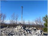
 | Šentilj v Slovenskih goricah - Plački vrh
Plački vrh is a peak in Slovenske Gorice. It lies in the municipality of Kungota, right on the border with Austria.It has a 28-metre-high lookout...
1 h |
 | Repnje - Smledniški hrib (Stari grad)
The Old Castle (also Smlednik Castle) is located on a small hill south-west of Valburg. A few years ago, the castle was rebuilt and the nearby tr...
1 h 15 min |