 | Topol - Polhograjska Grmada
Polhograjska Grmada is an 898 m high peak located in the heart of the Polhograjski Dolomiti. The summit, which has a registration box with a stam...
1 h 15 min |
| Belo - Polhograjska Grmada
Polhograjska Grmada is an 898 m high peak located in the heart of the Polhograjski Dolomiti. The summit, which has a registration box with a stam...
1 h 20 min |
 | Dom na Govejku - Osolnik
Osolnik is an 858 m high mountain located south of Škofja Loka and west of Medvode. From the top, where the Church of St. Mohor and Fortunatus st...
1 h |
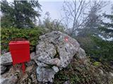
 | Črni Vrh - Pasja ravan
Pasja ravan is the second highest peak in the Polhograje Hills. A few decades ago, at 1029 m, it was the highest peak, but the Yugoslav army flat...
1 h |
 | Selo - Sveti Ožbolt (above Zminec)
Sveti Ožbolt is located on a scenic peak in the north of the Polhograjske Dolomites. It has a beautiful view of the Škofjeloško hribovje and part...
1 h 15 min |
 | Sv. Andrej - Sveti Ožbolt (above Zminec)
Sveti Ožbolt is located on a scenic peak in the north of the Polhograjske Dolomites. It has a beautiful view of the Škofjeloško hribovje and part...
1 h |
 | Selo - Mlaka
Mlaka or Prosen's Hill is a vegetated peak between Pasje ravnja and Tošč. The summit is not visible due to the forest....
1 h 10 min |
 | Dom na Goropekah - Vrh Svetih Treh Kraljev
The Church of the Holy Three Kings is situated on a lookout above the village of Vrh Svetih Treh kraljev. From the top, which has an observation ...
1 h 40 min |
| Sopot - Vrh Svetih Treh Kraljev
The Church of the Holy Three Kings is situated on a lookout above the village of Vrh Svetih Treh kraljev. From the top, which has an observation ...
1 h 25 min |
 | GEOSS - Slivna (Pivkelj)
Slivna or Pivkelj (also Pivkelj turn) as this peak is also called is located south of Limbarska Gora. Pivkelj is also the highest point of the Mo...
1 h |
 | Pivka - Osojnica
Osojnica is a forested hill located west of Pivka. There is no view from the top, which has a registration box, a stamp and a bench....
1 h |
 | Otlica - Sinji vrh
Sinji vrh is a scenic mountain located between Col, Ajdovščina and Predmeja. From the top, you can enjoy a beautiful view over most of western Sl...
1 h 20 min |
 | Vrbiški dol - Koča na Kozleku
The hut is located south-west of Ilirska Bistrica, just a few metres below the top of Kozlek. From the top, the view is only to the south and wes...
1 h |
 | Komarna vas - Gače
Gače is a popular excursion point for nature lovers and the only ski centre in Dolenjska (SC Bela), which offers pleasant skiing in winter and pl...
1 h |
 | Hrib-Loški Potok - Koča na Kamnem griču
The cottage is located on Kamný hill, a scenic peak rising south-west of Sodražica. The grassy summit, surrounded by forest, offers a beautiful v...
1 h 15 min |
 | Bločice - Križna gora
Križna gora is a partially overloked peak located above the village of Sveta Ana and Podlož. From the top of the hill on which the Church of the ...
1 h 15 min |
 | Zagrad - Ostrič
Ostrič (also marked as Žabnik on some maps) is a 1056m high peak located on the Slovenian side of Čičárija. From the uncultivated summit, on whic...
1 h 5 min |
 | Suhi Dol - Sivka (through forest)
Sivka is a grassy peak located in the westernmost part of the Polhograje Hills. In good weather, the peak offers a magnificent view from Snežnik ...
1 h 30 min |
| Suhi Dol - Sivka (by road)
Sivka is a grassy peak located in the westernmost part of the Polhograje Hills. In good weather, the peak offers a magnificent view from Snežnik ...
1 h 40 min |
 | Rovte - Medvedje Brdo (via Kamnikov Grič)
Medvedje Brdo is a small settlement located north of Hotedršice. The highest point of the village is a pleasant lookout point located on Šinkovco...
1 h 15 min |
 | Suhi Dol - Goli vrh (Uradna markirana pot)
Goli vrh, also known as Golni vrh on maps, is a nondescript forested peak located above the scattered settlement of Goli Vrh. There is no view fr...
1 h |
 | Mislinja - Časov vrh
Časov vrh (also called Časkov vrh on some maps) is a less distinct hill located between Fričev vrh and Črepič. As the peak is forested, there is ...
1 h 15 min |
 | Mislinja - Sveti Rupert (Završe)
St Rupert's Church is situated on a viewpoint, just south of the Frice Hill. From the church or its immediate surroundings, in fine weather, we h...
1 h 25 min |
 | Mislinja - Sveti Vid (Završe)
The Church of St.Vid, which has a small cemetery, is located in the middle of the scattered settlement of Završe. From the church, or its immedia...
1 h 10 min |
 | Sveta Jedert (Lajše) - Sveti Mohor (Zabrekve)
The Church of St. Mohor is situated on a 952 m high hill, between Zgornja Besnica and Selce. From the church, or its immediate surroundings, we h...
1 h 30 min |
 | Solarji - Deveti konfin (kota 930) (via Ježa)
Očna is a 906 m high peak located in the Kolovrat mountain range, west of Tolmina. From the meadow a few metres away from the summit, we have a b...
1 h 20 min |
 | Solarji - Deveti konfin (kota 942) (via Ježa)
Deveti konfin is a 930 m high peak in the Kolovrat mountain range, located between Ježa and Očno. There is no view from the summit, where a small...
1 h 10 min |
 | Cvetrež - Lašček
At 1071 m, Lašček is the highest peak of the Banjška plateau, a plateau rising above the Čepovan valley, the valley of the Soča River and the val...
1 h |
| Cvetrež - Lašček (by road)
At 1071 m, Lašček is the highest peak of the Banjška plateau, a plateau rising above the Čepovan valley, the valley of the Soča River and the val...
1 h 20 min |
 | Drnulk - Vrh Skopice
Vrh Skopice is a scenic peak located between the Čepovan valley, the Idrijca valley and the Trebuščice valley. From the top, where there is a reg...
1 h 20 min |
 | Ledinsko Razpotje - Sveta Marija Magdalena (Gore) (east path)
The Church of St Mary Magdalene is situated on a hill above the settlement Gore, which is above Idrija. From the church or its immediate surround...
1 h |
| Ledinsko Razpotje - Sveta Marija Magdalena (Gore) (west path)
The Church of St Mary Magdalene is situated on a hill above the settlement Gore, which is above Idrija. From the church or its immediate surround...
1 h 10 min |
 | Bele Vode (Sveti Andrej) - Sveti Križ above Bele Vode (upper path)
Sveti Križ is a scenic mountain located above Beli Voda. From the top, which is home to a number of church buildings and a conversion tower, we h...
1 h |
 | Koča pri Jelenovem studencu - Ledenik
At 1072 metres, Ledenik is the highest peak of Stojna, a forested ridge located between Kočevje and Kočevsko Rijeka. On the summit there is a reg...
1 h 15 min |
 | Rebrca / Rechberg - Rokov vrh / Rochusberg (via Bukovnik)
Rokov vrh is an 880 m high peak (according to some data 817 m) located between the settlements of Suha / Zauchen, Rebrca / Rechberg and Podkraj /...
1 h |
 | Sveti Jurij (Remšnik) - Sveti Pankracij (Radelca)
The Church of St Pancras on Radelca is located on the border ridge between Slovenia and Austria, but since 1966, following an inter-state agreeme...
1 h 15 min |
 | Sveta Katarina (Zgornja Kapla) - Sršenov vrh
Sršenov vrh is a 963-metre-high peak located in the Kozjak Mountains, specifically between Ožbalt and Zgornja Kapla. The peak itself does not off...
1 h |
 | Škalske Cirkovce - Stropnik
...
1 h |
 | Planinska koča Promina - Čavnovka (Promina) (po peš poti)
...
1 h |
 | Planinska koča Promina - Čavnovka (Promina) (po cesti)
...
1 h |
 | Slavica - Velika Slavica
...
1 h |
 | Omar - Kolevrat
...
1 h |