 | Laško (pokopališče Laško) - Cerkev sv. Mihaela na Šmihelu (mimo sv. Krištofa)
...
52 min |
 | Kubed - Lačna
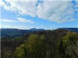
Lačna is a 451 m high hill located between Gračišče, Kubed and Hrastovlje. The top of the hill has a metal lookout tower, which offers a beautifu...
45 min |
 | Hrastovlje - Lačna
Lačna is a 451 m high hill located between Gračišče, Kubed and Hrastovlje. The top of the hill has a metal lookout tower, which offers a beautifu...
1 h 15 min |
 | Dragomer - Strmca (via Debeli hrib)
Strmca is a lesser-known and forested hill located between Brezje pri Dobrovi and Log pri Brezovici. There is no view from the top due to the for...
1 h 15 min |
 | Radeče - Svinjski rt
...
45 min |
 | Komare doline - Kuk
Kuk (also Ščukovec on some maps) is a 498 m high hill located north of the village of Movraž. From the top, where a small cross stands, you can e...
1 h 15 min |
 | Loka pri Žusmu (Žamerk) - Grad Žusem
...
50 min |
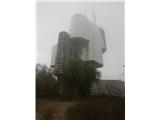
 | Šentilj v Slovenskih goricah - Plački vrh
Plački vrh is a peak in Slovenske Gorice. It lies in the municipality of Kungota, right on the border with Austria.It has a 28-metre-high lookout...
1 h |
 | Lovska koča Muljava - Veliki Petrovac (Petrova gora) (Roman path)
Veliki Petrovac is a 512-metre-high peak on Petrova Gora....
50 min |
 | Štore - Turn (Sv. Janez Krstnik) (via Kompole)
Turn is a peak above Štorá - Šentjanž nad Štorami. Slightly below the summit, on the site of the former Prežin Castle, the Church of St. John the...
1 h 15 min |
 | Lovska koča Muljava - Mali Petrovac (Petrova gora) (Roman path)
Mali Petrovac is a rather low hill located somewhere on the border between Banja and Kordun, Pannonian Croatia and Gorski Kotar. The top is compl...
1 h |
 | Hunting cottage Muljava - Mali Petrovac (Petrova gora) (via Mali Velebit)
Mali Petrovac is a rather low hill located somewhere on the border between Banja and Kordun, Pannonian Croatia and Gorski Kotar. The top is compl...
1 h 15 min |
 | Gojače - Školj Svetega Pavla above Vrtovin (past trough)
The St Paul's Collegium is located on a lookout above the village of Vrtovin, west of Ajdovščina. From the church, near which the registration bo...
1 h |
| Malovše - Školj Svetega Pavla above Vrtovin
The St Paul's Collegium is located on a lookout above the village of Vrtovin, west of Ajdovščina. From the church, near which the registration bo...
1 h 5 min |
| Bistrica ob Sotli - Svete gore (Evropska pešpot E7 iz Bistrice ob Sotli)
Svete gore is a 527 m high hill in the Orlice mountain range, located in the easternmost part of the Posavje hills. The top of the hill, on which...
50 min |
 | Ljubljana (Zalog) - Debenji vrh
Debenji vrh, also Debni or Deben vrh, is the highest peak of Kašeljski Hill, a small mountain range located between the valley of Besnica and the...
45 min |
 | Ljubljana (Zalog) - Debenji vrh
Debenji vrh, also Debni or Deben vrh, is the highest peak of Kašeljski Hill, a small mountain range located between the valley of Besnica and the...
45 min |
 | Ljubljana (G Design Hotel) - Gradišče (above Dobrova)
Gradišče is a forested peak located south of Dobrova and north of Brezovica pri Ljubljani. There is no view from the top, where there is a box wi...
45 min |
 | Tremerje - Vipota
Vipota is a 532-metre-high peak south of Celje, above the left bank of the Savinja. Approaches to the summit are possible from several directions...
1 h |
 | Zagrad - Vipota
Vipota is a 532-metre-high peak south of Celje, above the left bank of the Savinja. Approaches to the summit are possible from several directions...
1 h |
 | Zagrad - Vipota (via crossing Ivankovič)
Vipota is a 532-metre-high peak south of Celje, above the left bank of the Savinja. Approaches to the summit are possible from several directions...
1 h 15 min |
 | Zbelovo (railway underpass) - Ljubična gora (via Marijine stopinje)
Ljubična gora is a hill located above Ljubično, Zbelovo and Zbelovo Gora. The hill is hidden in the forest and is not very visible, but the churc...
45 min |
 | Zbelovo (railway underpass) - Ljubična gora
Ljubična gora is a hill located above Ljubično, Zbelovo and Zbelovo Gora. The hill is hidden in the forest and is not very visible, but the churc...
45 min |
 | Zgornje Poljčane - Ljubična gora
Ljubična gora is a hill located above Ljubično, Zbelovo and Zbelovo Gora. The hill is hidden in the forest and is not very visible, but the churc...
1 h 15 min |
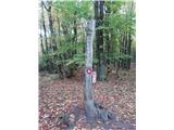
 | Velika Kostrevnica - Kožljevec
Kožljevec (also Kožlevec) is a 533 m high hill above Cerovica in the municipality of Šmartno pri Litija. The top, which also has a box with a reg...
1 h 10 min |
 | Dragomer - Vrh (Debeli hrib) (on Pentlja)
The summit is a 540 m high hill located on the Debeli hrib ridge, a ridge situated between the Ljubljana Marshes and the Horjulščice River valley...
1 h |
 | Galicija - Planinski dom Šentjungert
The mountain lodge is located just a few metres below the top of Gora, on which the Church of St Kunigunde, built in the 14th century, stands. Th...
45 min |
 | Zagorica pri Dobrniču - Lisec (Liška gora)
Lisec is a 565 m high peak located north to north-east of Žužemberk and south-west of Dobrnice. On the top of the peak stands a metal cross, to w...
1 h |
 | Jakob pri Šentjurju - Rifnik
Rifnik is a 568m high peak located south of Šentjur near Celje. The summit, which is famous for its archaeological site, offers a beautiful view ...
45 min |
| Šentjur - Rifnik
Rifnik is a 568m high peak located south of Šentjur near Celje. The summit, which is famous for its archaeological site, offers a beautiful view ...
45 min |
 | Gorica pri Slivnici - Rifnik
Rifnik is a 568m high peak located south of Šentjur near Celje. The summit, which is famous for its archaeological site, offers a beautiful view ...
1 h 15 min |
| Vezovje (avtobusna postaja Vezovje most) - Rifnik
Rifnik is a 568m high peak located south of Šentjur near Celje. The summit, which is famous for its archaeological site, offers a beautiful view ...
45 min |
 | Podčetrtek (sveti Lovrenc) - Zavetišče Šmarnica na Mali Rudnici (mimo gradu Podčetrtek)
...
1 h 5 min |
| Podčetrtek (sveti Lovrenc) - Zavetišče Šmarnica na Mali Rudnici
...
1 h |
 | Trebnje Castle - Trebni vrh (steep path)
Trebni vrh is a 581-metre-high hill located south or south-west of Trebnje. On the top of the forested hill there is a bench, and near it there i...
45 min |
| Trebnje Castle - Trebni vrh (via caves)
Trebni vrh is a 581-metre-high hill located south or south-west of Trebnje. On the top of the forested hill there is a bench, and near it there i...
50 min |
 | Trebnje Castle - Trebni vrh (steep path via hunting cottage)
Trebni vrh is a 581-metre-high hill located south or south-west of Trebnje. On the top of the forested hill there is a bench, and near it there i...
55 min |
| Trebnje Castle - Trebni vrh (via caves and hunting lodge)
Trebni vrh is a 581-metre-high hill located south or south-west of Trebnje. On the top of the forested hill there is a bench, and near it there i...
1 h |
 | Migojnice - Dom na Bukovici
The Bukovica Mountain House is located just a few metres below the top of the forested Bukovica. From the house, near which there is a large mead...
45 min |
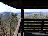
 | Šešče pri Preboldu - Dragov dom na Homu (via Lajnarjev hrib)
Drago's home is located on a scenic hill, south of Šempeter. From the top, which is also the Church of St. Magdalene, there is a beautiful view f...
1 h |
| Šešče pri Preboldu - Dragov dom na Homu (Brdovska pot)
Drago's home is located on a scenic hill, south of Šempeter. From the top, which is also the Church of St. Magdalene, there is a beautiful view f...
1 h 15 min |
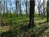
 | Tremerje - Veliki Slomnik
Veliki Slomnik is a peak located between Košnica pri Celju and Liboje. There is no view from the summit, which has a registration box, due to the...
1 h |
 | Bad Gleichenberg (Sägewerk Weiss) - Stradner Kogel
Stradner Kogel is the highest hill in south-eastern Styria. The hill is of volcanic origin, and its vegetation prevents views in any direction. O...
1 h 15 min |
| Haag - Stradner Kogel
Stradner Kogel is the highest hill in south-eastern Styria. The hill is of volcanic origin, and its vegetation prevents views in any direction. O...
1 h 10 min |
 | Prebold - Žvajga (severni vrh) (vzhodna pot)
...
50 min |
 | Prebold - Žvajga (severni vrh) (zahodna pot)
...
1 h 5 min |
 | Grgar - Frančiškov hrib
Frančiškov hrib is a less prominent peak located on Skalnica, whose highest peak is the 681-metre Sveta Gora. From the lookout peak, on which the...
1 h 15 min |