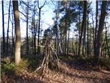
 | Šujica (Na Gmajni) - Toško Čelo (along the stream Ostrožnik)
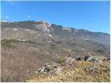
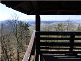
Toško Čelo is a 590 m high hill above the village of the same name. From the top, or slightly lower down, you have a beautiful view of part of Lj...
55 min |
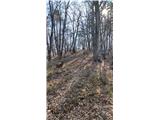
 | Šujica (Na Gmajni) - Toško Čelo
Toško Čelo is a 590 m high hill above the village of the same name. From the top, or slightly lower down, you have a beautiful view of part of Lj...
50 min |
 | Sora - Hom (steep past cemetery)
Hom is a 715 m high peak rising steeply south-west of the village of Sora. The summit, which is partly covered with forest, offers a beautiful vi...
50 min |
 | Grgar - Sveta Gora (by road)
Sveta Gora is known mainly by the faithful and locals. Sveta Gora is a well-known pilgrimage centre above Nova Gorica. It is visited by believers...
1 h 15 min |
 | Gojače - Školj Svetega Pavla above Vrtovin (via water tower)
The St Paul's Collegium is located on a lookout above the village of Vrtovin, west of Ajdovščina. From the church, near which the registration bo...
1 h |
 | Liboje (quarry) - Kotečnik (via eastern ridge)
Kotečnik is a peak in Posavsko hribovje, located north of Šmohor. Kotečnik is a peak with two entry boxes. The first one is located on the wester...
1 h 5 min |
 | Grgar - Vodice (by road)
Vodice (according to some records also Sv. Jakob) is a peak located in the western part of the Banjška plateau. The summit, on which the mausoleu...
1 h 15 min |
 | Celje (hanging bridge) - Hom above Celje
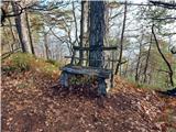
Hom is a forested peak located north of Košnica near Celje. There is a small bench on top of the summit next to the registration box....
1 h |
 | Celje (hanging bridge) - Hom above Celje (via Petriček and Lisce)
Hom is a forested peak located north of Košnica near Celje. There is a small bench on top of the summit next to the registration box....
1 h 10 min |
 | Podgrad - Debenji vrh
Debenji vrh, also Debni or Deben vrh, is the highest peak of Kašeljski Hill, a small mountain range located between the valley of Besnica and the...
1 h |
| Podgrad - Debenji vrh (via old castle Osterberg)
Debenji vrh, also Debni or Deben vrh, is the highest peak of Kašeljski Hill, a small mountain range located between the valley of Besnica and the...
50 min |
 | Podlipoglav - Pugled (past the guard post)
Pugled is a 615m high peak located between Podlipoglav and Veliki Lipoglav. The view from the top of the large NOB monument is limited due to the...
50 min |
 | Podlipoglav - Pugled (on the western ridge)
Pugled is a 615m high peak located between Podlipoglav and Veliki Lipoglav. The view from the top of the large NOB monument is limited due to the...
50 min |
 | Fala Grad - Lobnikov vrh
Lobnikov vrh is a forested peak above the Drava Valley, situated between Fala and Ruta. From the east, it loks like a solitary rock due to its di...
1 h 15 min |
 | Dobrova - Vrhe above Dobrova
Vrhe is a lesser-known but important peak in the extreme SE part of the Polhograje hills. It is reached by several unmarked tracks and trails lea...
50 min |
 | Hruševo - Vrhe above Dobrova
Vrhe is a lesser-known but important peak in the extreme SE part of the Polhograje hills. It is reached by several unmarked tracks and trails lea...
1 h |
 | Izlake (Medijske toplice) - Vrhija (via Podlipovica)
Vrhija is a 648 m high hill located west of Izlake and east of Kolovrat. It lies between Kalanov hrib and Kolovrat ribs, viewed from the N-S dire...
1 h 15 min |
 | Brezovica pri Ljubljani - Vrh (Debeli hrib)
The summit is a 540 m high hill located on the Debeli hrib ridge, a ridge situated between the Ljubljana Marshes and the Horjulščice River valley...
1 h |
 | Zagorje ob Savi - Vrh (Šticna) (Šmarjakova pot)
The hill, known in Zasavje as Šticna, is a 679 m high hill located between Zagorje ob Savi and Kisovec. The summit rewards you with beautiful vie...
1 h |
 | Dvor - Kucelj above Polhov Gradec (on marked path)
Kucelj is a lesser-known peak located between Polhov Gradec and Dvůr pri Polhovem Gradcu. From the 705-metre-high peak, there are views towards G...
1 h |
| Dvor - Kucelj above Polhov Gradec (on unmarked path)
Kucelj is a lesser-known peak located between Polhov Gradec and Dvůr pri Polhovem Gradcu. From the 705-metre-high peak, there are views towards G...
1 h |
 | Sora - Breznik (Boben)
Breznik, aka Boben, is a 643-metre-high peak located above the right bank of the Ločnica River, specifically above the Sora, Rakovnik, Goričane a...
1 h 5 min |
| Rakovnik - Breznik (Boben)
Breznik, aka Boben, is a 643-metre-high peak located above the right bank of the Ločnica River, specifically above the Sora, Rakovnik, Goričane a...
55 min |
 | Tremerje - Kamčič (on the ridge of Mali Slomnik)
Kamčič is a vegetated peak in Posavsko hribovje, located north of Šmohor, between Kotečnik on the left and Veliki Slomnik on the right. It can be...
1 h 15 min |
 | Podgrad - Grmadnik
Grmadnik is a 569-metre-high peak above the valley of the Besnica stream between Podgrad and Besnica. The Borovnice hiking trail passes just belo...
55 min |
 | Podgrad - Španov vrh (Besnica)
Španov vrh is a 559-metre-high peak above the valley of the Besnica stream between Podgrad and Besnica. Just below the summit is the Borovnice hi...
50 min |
 | Sveti Jurij - Joški vrh
Joški vrh is a 595-metre-high peak located on the northern side of Donacca Mountain. A short unmarked trail leads to the summit, which branches o...
1 h 5 min |
 | Stari Grad (Šega) - Dedni vrh (Šuštarica)
Dedni vrh, also called Šuštarica, is a lesser known peak in Karawanks, located north of Plešivec. The peak is located in the forest and in the su...
1 h |
 | Ruše - Lorbekov vrh
Lorbekov vrh is a 578-metre-high peak located south-west of Ruše. The peak is located in a forest, but the meadow just below the peak offers a be...
45 min |
 | Ožbalt (jez na potoku Črmenica) - Turška peč (po kolovozu)
...
1 h |
 | Ruše - Globokarjev vrh
...
1 h 15 min |
 | Borovnica - Planina nad Borovnico (Češnjeva pot)
...
55 min |