 | Kozji hrbet - Možic
Možic is a 1602 m high peak located west of Soriška mountain pasture. It is at the highest point of the peak that there is an old military bunker...
1 h |
 | Volovljek - Kranjska reber (on unmarked path)
Kranjska reber or Peak Kašna planina (1435 m) is a volcanic mountain. From the top, where the registration box with the stamp is located, we have...
1 h 15 min |
 | Planina Vetrh - Bela peč (via cottage Pr Zdravc)
The mountain, which is known mainly by climbers, is located north of Storžič on the slopes of Konjščice. From the top there is a beautiful view o...
1 h 15 min |
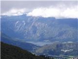
 | Križovec - Ptičji vrh
Ptičji vrh is a 1550 m high mountain located between Barentaler Kotschna and Golica. The summit, which borders between Slovenia and Austria, offe...
1 h |
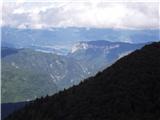
 | Železnica - Techantinger Mittagskogel (Trupejevo poldne)
The mountain is located on the border with Austria and is above Gozd Martuljko. From the uncultivated summit there is a beautiful view of Julian ...
1 h 15 min |
 | Planina Dol - Koritni vrh (Velika planina)
Koritni vrh is a 1648 m high mountain located in the northern part of Velika planina. From the top, on which stands a small cross, a beautiful vi...
1 h |
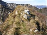
 | Kozji hrbet - Šavnik
Šavnik is a grassy peak located between the Soriška planina and Kobla ski resorts. From the summit, which has a registration box with a stamp, yo...
50 min |
 | Ski hotel Vogel - Zavitar
The summit is located to the east of the Vogel ski resort. The top is overgrown with dwarf pines and just a few metres from the top there is a be...
1 h |
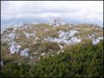
 | Pod Hlipovcem - Veliki Travnik (Turnovka) (strma pot)
Veliki Travnik, or Turnovka as the locals call it, is located on the western edge of the Smrekov Mountains. From the top of the hill, where a woo...
50 min |
 | Za Malim vrhom - Krevl
Krevl is a 1515 m high peak located to the south of the Kobla ski area, more precisely between Koble Peak and Kravje Črna Gora. From the summit, ...
1 h |
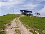 | Dom na Gospincu - Krvavec
Krvavec is an 1853 m high peak located in the heart of the ski resort of the same name. The summit, which is criss-crossed with cable cars, offer...
1 h |
 | Planina pod Golico - Španov vrh
Španov vrh is a 1334m high mountain located between Javorniški Rovt and Mountain pasture below Golica. From the top, reached by the cable car of ...
1 h 15 min |
 | Planina Lom - Kobilja glava
Kobilja glava is a 1475 m high peak located east of Tolmin. From the top with a cross, we have a beautiful view of the Krn, the Lower Bohinj Moun...
1 h 15 min |
 | Koča na Gozdu - Visoki Mavrinc
Visoki Mavrinc (Špica v Sedelcih) is a 1562 m high mountain located between Suha, Mala and Velika Pišnica. From the top of the peak, where there ...
1 h 15 min |
 | Rotek - Erbelc
Erbelc is a 1308-metre-high peak rising steeply above Zgornja Sorica. From the summit, where the registration box is located, you can enjoy a bea...
1 h 15 min |
| Spodnje Danje - Erbelc
Erbelc is a 1308-metre-high peak rising steeply above Zgornja Sorica. From the summit, where the registration box is located, you can enjoy a bea...
1 h 15 min |
 | Rotek - Tonderškofel
Tonderškofel is a 1326-metre high peak located between Soriška Peć and Erbellec. The partly overgrown peak, which has no marked trail, offers a b...
1 h 15 min |
| Spodnje Danje - Tonderškofel
Tonderškofel is a 1326-metre high peak located between Soriška Peć and Erbellec. The partly overgrown peak, which has no marked trail, offers a b...
1 h 15 min |
 | Planina pod Golico - Na pečeh pri Črnem Vrhu
On the Peaks is a lesser-known lookout peak with an altitude of 1318 metres, rising east above the village Mountain pasture below Kahlkogel. In t...
1 h 5 min |
 | Topla (Končnik) - Šoparjev vrh
Šoparjev vrh is a 1524 m high mountain located between Olševa and Peca, more precisely on the ridge that separates the Koprivna valley from the T...
1 h 15 min |
| Koprivna (Kumer) - Šoparjev vrh
Šoparjev vrh is a 1524 m high mountain located between Olševa and Peca, more precisely on the ridge that separates the Koprivna valley from the T...
1 h 10 min |
 | Ravne - Bela peč (above Dovje)
Bele peči is a less known peak, located above the marked Dovje - Dovška Baba trail. The summit offers a beautiful view to the south and west, whi...
45 min |
| Erjavčev rovt - Bela peč (above Dovje)
Bele peči is a less known peak, located above the marked Dovje - Dovška Baba trail. The summit offers a beautiful view to the south and west, whi...
1 h 15 min |
 | Breitalm - Zachenkreuz
Zachenkreuz is a 1601 m high peak located above the mountain pasture Teichalm. A wooden cross stands on the summit, which is mostly covered by a ...
1 h 15 min |
 | 2nd turn of Vršič road - Škrbinjek
...
1 h |
 | Bürgeralm (Panoramastraße) - Schönleitenhaus (Windgrube) (on southern ridge)
...
50 min |