 | Črne njive - Ahac
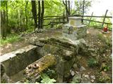
Ahac or St. Ahac is a 799 m high peak located east of Ilirska Bistrica. The summit, which is home to a registration box, a cross and the ruins of...
40 min |
 | Zaplana (St. Urh and St. Martin) - Ulovka
Ulovka is the peak between Zaplana and the Shelter at Mountain pasture above Vrhnika. From the top, which is reached by ski lifts, there is a nic...
50 min |
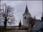
 | Topol - Sveti Jakob
The Church of St James is located on a hill north of the village of Topol near Medvode. From the top, where there is a registration box with a st...
40 min |
| Topol - Sveti Jakob (via homestead Na Vihri)
The Church of St James is located on a hill north of the village of Topol near Medvode. From the top, where there is a registration box with a st...
45 min |
 | Hunting sports association Vinska Gora - Vinska gora
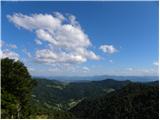
Vinska gora, marked on some maps as neighbouring Temnjak, is an 806 m high hill located north-west of Dobrnež and north-east of Vinská Gora. The ...
40 min |
 | Belo - Goljek
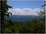
Goljek is an 809 m high peak located east of Polhograjska Grmada. The view from the summit, which is home to the remains of a former watchtower o...
40 min |
 | Srednje - Globočak
Globočak is an 809 m high peak located in the Kanalski Kolovrat mountain range. The summit, which contains some remnants of the First World War, ...
35 min |
 | Rašpor - Gradina Rašpor (po markirani poti)
...
45 min |
 | Križna Gora - Archangel Gabriel (Planica)
Planica is an 824 m high peak located north of Škofja Loka, between Krizna Gora and Planica. From the top, where the Church of St. Gabriel the Ar...
35 min |
 | Čepulje - Archangel Gabriel (Planica)
Planica is an 824 m high peak located north of Škofja Loka, between Krizna Gora and Planica. From the top, where the Church of St. Gabriel the Ar...
50 min |
 | Čepulje - Špičasti hrib
Špičasti hrib (Špičasti vrh on maps) is an 837 m high peak located to the west of Sveti Jošto above Kranj. There is no view from the top, which h...
40 min |
 | Javornik - Sveti Jošt above Kranj
Sveti Jošt above Kranj, is a hill located to the west of the slightly lower Šmarjetna Gora. From the top, where the Church of St. Jošto and the J...
40 min |
 | Rovišče - Zasavska Sveta gora (by road)
Zasavska Sveta gora is a popular excursion point located between Litija and Izlaki. From the top, where the parish church of the Nativity of the ...
35 min |
| Stružnica - Kuželjska stena
Kuželjska stena rises majestically above the village of Kuželj in the Kolpa valley. It is a rise in a fault that winds above the upper Kolpa vall...
45 min |
 | Podlanišče - Veliki vrh (Lajše)
Veliki vrh is an almost 900 m high peak rising south of Cerkno. From the top, where there are several television and radio transmitters covering ...
40 min |
 | Smrečje - Vrh Svetih Treh Kraljev (by road)
The Church of the Holy Three Kings is situated on a lookout above the village of Vrh Svetih Treh kraljev. From the top, which has an observation ...
45 min |
 | Smrečje - Vrh Svetih Treh Kraljev (footpath)
The Church of the Holy Three Kings is situated on a lookout above the village of Vrh Svetih Treh kraljev. From the top, which has an observation ...
40 min |
| Smrečje - Vrh Svetih Treh Kraljev (via Jereb)
The Church of the Holy Three Kings is situated on a lookout above the village of Vrh Svetih Treh kraljev. From the top, which has an observation ...
45 min |
| Račevsko jezero - Vrh Svetih Treh Kraljev
The Church of the Holy Three Kings is situated on a lookout above the village of Vrh Svetih Treh kraljev. From the top, which has an observation ...
45 min |
 | Smrečje - Lavrovec
Lavrovec is an 890 m high peak located between Horjul and Žirmi. From the top, where the solar irradiance meter is located (official measuring po...
40 min |
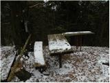
 | Dom na Govejku - Gontarska planina
Gontarska planina is an 894 m high mountain located between Osolnik and Tosce. From the top, where there are two benches, we have a beautiful vie...
35 min |
 | Planinski dom pod Ježo - Deveti konfin (kota 930)
Očna is a 906 m high peak located in the Kolovrat mountain range, west of Tolmina. From the meadow a few metres away from the summit, we have a b...
55 min |
 | Planinski dom pod Ježo - Deveti konfin (kota 942)
Deveti konfin is a 930 m high peak in the Kolovrat mountain range, located between Ježa and Očno. There is no view from the summit, where a small...
45 min |
 | Solarji - Ježa
Ježa is a 949 m high peak located west of Volč, on the slopes of Kolovrat. From the top, where there is a registration box with a registration bo...
45 min |
 | Velika vrata - Mala Plešivica
Mala Plešivica, which is higher than the neighbouring Velika Plešivica, is a scenic peak located to the west of the village of Golac on the borde...
35 min |
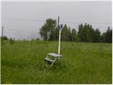
 | Mesnice - Rotovc
Rotovc is a 964 m high peak located northeast of Rakitna. From the top, where a wooden bench stands, we have a beautiful view towards the already...
55 min |
 | Brancljeva senožet - Rotovc
Rotovc is a 964 m high peak located northeast of Rakitna. From the top, where a wooden bench stands, we have a beautiful view towards the already...
45 min |
 | Planinski dom Vrhe - Sveta planina (Partizanski vrh)
Sveta planina, also Partizanski vrh, is a 1011 m high mountain located between Čemšeniška mountain pasture and Mrzlica. From the top, where a sma...
35 min |
 | Travna Gora - Koča na Kamnem griču
The cottage is located on Kamný hill, a scenic peak rising south-west of Sodražica. The grassy summit, surrounded by forest, offers a beautiful v...
45 min |
 | Kamen - Mokrc
Mokrc on maps Mokrec is a 1059 m high mountain located to the east of Iškega Vintgar. The summit is forested and therefore has no view. For some ...
40 min |
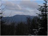
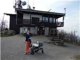 | Zamlake - Krim
Krim is a 1107 m high mountain rising south of the Ljubljana Marshes. From the top of the mountain, where the mountain lodge and a number of tran...
50 min |
 | Pohorje cable car - Ledinekov kogel
Ledinekov kogel is a 1182 m high peak located north of Maribor hut. Just below the summit is a fenced area with a radar tower....
40 min |