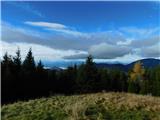
 | Snežniška Grda jama - Snežnik (via Mali Snežnik)
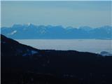
Snežnik or Veliki Snežnik is the highest peak in the near and far surroundings with a height of 1796 m. It offers a beautiful view over most of S...
1 h 25 min |
 | Gašperjev hrib - Snežnik
Snežnik or Veliki Snežnik is the highest peak in the near and far surroundings with a height of 1796 m. It offers a beautiful view over most of S...
1 h 30 min |
 | Gašperjev hrib - Snežnik
Snežnik or Veliki Snežnik is the highest peak in the near and far surroundings with a height of 1796 m. It offers a beautiful view over most of S...
1 h 30 min |
 | Črni Kal - Blegoš (by road, via hut)
Blegoš is a 1562 m high mountain located between Selška and Poljane Sora. From the grassy summit, on which there is a stamp and a registration bo...
1 h 30 min |
 | Črni Kal - Blegoš (direct way)
Blegoš is a 1562 m high mountain located between Selška and Poljane Sora. From the grassy summit, on which there is a stamp and a registration bo...
1 h 10 min |
 | Črni kal - Blegoš (via Prva ravan)
Blegoš is a 1562 m high mountain located between Selška and Poljane Sora. From the grassy summit, on which there is a stamp and a registration bo...
1 h 20 min |
 | Bohinjsko sedlo - Možic (direct way)
Možic is a 1602 m high peak located west of Soriška mountain pasture. It is at the highest point of the peak that there is an old military bunker...
1 h 15 min |
| Bohinjsko sedlo - Možic (by Lajnar)
Možic is a 1602 m high peak located west of Soriška mountain pasture. It is at the highest point of the peak that there is an old military bunker...
1 h 30 min |
 | Volovljek - Kranjska reber
Kranjska reber or Peak Kašna planina (1435 m) is a volcanic mountain. From the top, where the registration box with the stamp is located, we have...
1 h 20 min |
 | end of road on Vogar - Pršivec (direct way)
Lookout Mountain is located above Lake Bohinj. The view is extensive on all sides. Triglav and the mountains around it can be seen, and on the ot...
1 h 30 min |
 | Leška gmajna - Lepenatka
Lepenatka is a grassy peak located south of the 1557 m high Rogatec. From the top, which has a registration box and a stamp, we have a beautiful ...
1 h 15 min |
 | Bohinjsko sedlo - Šavnik (by Lajnar)
Šavnik is a grassy peak located between the Soriška planina and Kobla ski resorts. From the summit, which has a registration box with a stamp, yo...
2 h |
 | Bohinjsko sedlo - Šavnik
Šavnik is a grassy peak located between the Soriška planina and Kobla ski resorts. From the summit, which has a registration box with a stamp, yo...
1 h 30 min |
 | Ski hotel Vogel - Šija
The peak is located above the Vogel ski slope in the Lower Bohinj Mountains. From the top there is a beautiful view of the neighbouring peaks in ...
1 h 30 min |
 | Tonkina koča na Vršiču - Sovna glava (on old road)
Sovna glava is a 1750 m high grassy peak located between Prisank and the Vršič Alpine Pass. From the top, you have a beautiful view of the peaks ...
1 h 10 min |
 | Kramarica - Smrekovec (via Bukov stan)
Smrekovec is a volcanic mountain on the eastern edge of the Smrekov Mountains. The extensive grassy summit, on which stands a pyramid with a regi...
1 h 30 min |
| Kramarica - Smrekovec (by road)
Smrekovec is a volcanic mountain on the eastern edge of the Smrekov Mountains. The extensive grassy summit, on which stands a pyramid with a regi...
1 h 30 min |
 | Dom na Smrekovcu - Krnes
The summit is located in the heart of the Smrekov Mountains and has a beautiful view. Peca, Uršlja gora and part of the highest peaks of the Savi...
1 h 20 min |
 | Dom na Smrekovcu - Komen
At 1684m, Komen is the highest peak of the Smrekov Mountains, a mountain range bordering Styria and Carinthia. From the top, in good weather, we ...
2 h |
 | Planina Vodol - Veliki Travnik
Veliki Travnik, or Turnovka as the locals call it, is located on the western edge of the Smrekov Mountains. From the top of the hill, where a woo...
2 h |
 | Mala Lazna - Mali Golak
Mali Golak is the highest of the Golaks. It was named not because it was the smallest but because it had the smallest mountain pasture. On the ma...
1 h 25 min |
 | Škrbina - Mali Golak
Mali Golak is the highest of the Golaks. It was named not because it was the smallest but because it had the smallest mountain pasture. On the ma...
2 h |
 | Škrbina - Srednji Golak
Srednji Golak is located between Mali and Veliki Golak on the plateau of the Trnovo Forest above Predmeja. The summit is covered with dwarf pines...
1 h 15 min |
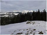
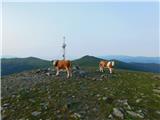
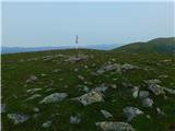
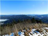
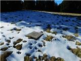
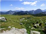
 | Sviščaki - Mali Snežnik
Mali Snežnik is a peak on the west ridge of Snežnika. Vrh, which is covered with dwarf pines, has a fine view of the neighbouring Veliki Snežnik ...
1 h 50 min |
 | Walischeben - Speikkogel (Packalpe)
Speikkogel is a vast and grassy peak in the Packalps. From the top you can enjoy a beautiful view of the Slovenian mountains and the mountains of...
2 h |
 | Salzstiegelhaus - Speikkogel (Packalpe)
Speikkogel is a vast and grassy peak in the Packalps. From the top you can enjoy a beautiful view of the Slovenian mountains and the mountains of...
1 h 15 min |
 | Rifugio Pelizzo - Monte Mataiur/Matajur (via Fonte Skrila)
Monte Mataiur is a scenic mountain located on the border between Slovenia and Itali. From the top, you have a beautiful view of the Kobarid or Br...
1 h 15 min |
 | Ljubelj - Polna peč
Polna peč, also marked on maps as Ravna peč, is located above the Ljubljana Tunnel. From the top, which is somewhat precipitous, there is a beaut...
1 h 15 min |
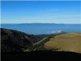
 | Platak - Snježnik (via grlo)
Snježnik is a scenic mountain in the western part of Gorski Kotar. The summit offers a beautiful view of the Kvarner islands, the Gulf of Reška, ...
1 h 30 min |
| Platak - Snježnik (via crest)
Snježnik is a scenic mountain in the western part of Gorski Kotar. The summit offers a beautiful view of the Kvarner islands, the Gulf of Reška, ...
1 h 30 min |
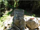 | Atelsko sedlo - Boskovec
At 1587m, Boskovec is the highest peak of the Golta plateau. From the top of the lookout tower, you can see part of Kamnik Savinja Alps and the e...
1 h 30 min |
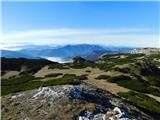
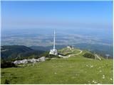 | Planina Jezerca - Krvavec
Krvavec is an 1853 m high peak located in the heart of the ski resort of the same name. The summit, which is criss-crossed with cable cars, offer...
1 h 10 min |
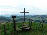
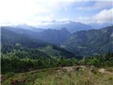
 | Koča na planini Stador - Kobilja glava
Kobilja glava is a 1475 m high peak located east of Tolmin. From the top with a cross, we have a beautiful view of the Krn, the Lower Bohinj Moun...
1 h 15 min |
 | Planina Loka - Lanež (via Durce)
Lanež is a less distinct peak located in the eastern part of Raduha. The spacious peak offers a beautiful view of the nearby Mala Raduha, Olševa,...
1 h 25 min |
 | Panoramarestaurant Oben - Končnikov vrh
Končnikov vrh is a 2109 m high mountain located in the central part of Pec. The grassy peak offers a beautiful view along the Pec ridge and the m...
1 h 20 min |
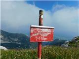 | Panoramarestaurant Oben - Končnikov vrh (mimo stare koče)
Končnikov vrh is a 2109 m high mountain located in the central part of Pec. The grassy peak offers a beautiful view along the Pec ridge and the m...
1 h 15 min |
 | Pod Peco/Koprein-Petzen - Topitza
Topitza, or Topitza in German, is a 1649 m high peak located northeast of Železna Kapla. From the summit, on which the cross stands, we have a be...
1 h 15 min |
 | Ski hotel Vogel - Visoki Orlov rob
Visoki Orlov rob is an 1800 m high peak located in the immediate vicinity of the upper station of the single-seater Šija. The summit, located sli...
1 h 15 min |
 | Soriška peč - Žbajnek
Žbajnek is a 1538 m high peak located west of Ratitovec. The grassy peak, surrounded by a rare forest, offers a beautiful view of Julian Alps, Ka...
1 h 30 min |
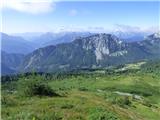
 | Bohinjsko sedlo - Kačji rob (Ovharn)
Kačji rob is a 1520 m high peak located between mountain pasture Zgornji Jirn and the lesser known peak Žbanjek. The summit, which bears the Rati...
2 h |
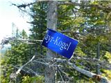
 | Weinebene - Hühnerstütze (Golica/Koralpe)
Hühnerstütze is a 1989 m high peak located in the Golice / Koralpe mountain range. From the unmarked, mostly grassy summit, we have a beautiful v...
2 h |
 | parking below Weinebene - Hühnerstütze (Golica/Koralpe) (panoramic path)
Hühnerstütze is a 1989 m high peak located in the Golice / Koralpe mountain range. From the unmarked, mostly grassy summit, we have a beautiful v...
2 h |
 | Weinebene Straße - Weberkogel
Weberkogel is a less prominent peak located north to north-west of the Weinebene Alpine Pass. On the 1805 m high summit is a medium-sized cairn a...
1 h 30 min |
| Gasthof Pfeifferstocker - Weberkogel
Weberkogel is a less prominent peak located north to north-west of the Weinebene Alpine Pass. On the 1805 m high summit is a medium-sized cairn a...
1 h 50 min |
 | Bohinjsko sedlo - Slatnik (southeastern peak) (past barracks)
Slatnik) is a scenic mountain that rises steeply above Baška Grapa on one side and descends more gently towards Soriška planina on the other side...
1 h 10 min |
 | Klippitztörl - Forstalpe (Saualpe)
Forstalpe is an unstratified peak in the Svinja mountain pasture / Saualpe massif. The stamp for Forstalpe is located in an interesting natural w...
1 h 40 min |
 | Pension Camping Holzmeister - Heulantsch
Heulantsch is a 1473m high grassy hill above the Teichalm, which together with the "Sommeralm" forms the largest area of mountain meadows in the ...
1 h 15 min |
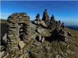 | parking below Weinebene - Steinmandl (Golica / Koralpe) (via Grünangerhütte)
Steinmandl is a scenic peak in the Golice / Koralpa mountain range, on which a large number of stone columns have been erected....
1 h 40 min |
 | Feistritzsattel - Grabmayr-Kogel
...
1 h 40 min |
 | St. Vinzenz (St. Vinzenz) - Dreieckkogel
...
1 h 35 min |
 | Planinski dom Orlove stine - Svilaja (mimo Umaca)
...
2 h |
 | Feistritzsattel - Arabichl
...
1 h 20 min |
 | Sommeralm - Osser
...
2 h |
 | Teichalm (Angerwirt) - Osser
...
1 h 20 min |
| Teichalm (Harrerhütte) - Osser
...
1 h 35 min |
| Pension Camping Holzmeister - Osser
...
1 h 15 min |
 | Straßegg - Hochschlag
...
1 h 45 min |
 | Hebalm (Gasthaus Zur Rehbockhütte) - Barofen
...
2 h |
 | Weinebene Straße - Barofen
...
1 h 40 min |
| Gasthof Pfeifferstocker - Barofen
...
2 h |
 | Weinebene Straße - Renneiskogel
...
1 h 25 min |
| Gasthof Pfeifferstocker - Renneiskogel
...
1 h 45 min |
 | Nassfeld - Javornik / Auernig
...
1 h 30 min |
| Nassfeld - Javornik / Auernig (via Auernig Alm)
...
1 h 35 min |
 | Nassfeld - Garnitzenberg / Monte Carnizza (via Auernig Alm)
...
1 h 50 min |
| Nassfeld - Garnitzenberg / Monte Carnizza (Auernig Höhenweg)
...
2 h |
 | Kohlebnerstand - Hoher Klapf
...
1 h 40 min |
 | Nassfeld - Kronalpe / Monte Corona
...
1 h 35 min |