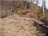
 | Ledinsko Razpotje - Gradišče (above Spodnja Idrija) (steep path)
Gradišče is a 998-metre-high peak that separates the Ledine plateau in the north-western part of the Rovtarski hills from the Idrijca valley. A t...
1 h |
 | Ledinsko Razpotje - Gradišče (above Spodnja Idrija) (gentle path)
Gradišče is a 998-metre-high peak that separates the Ledine plateau in the north-western part of the Rovtarski hills from the Idrijca valley. A t...
1 h 15 min |
 | Šenturška Gora - Prgozdnik (Martinova pot)
Prgozdnik is a 1013-metre-high peak located on the ridge of the same name, between the settlements of Ambrož pod Krvavcem, Šenturška Gora, Apno a...
1 h 5 min |
 | Apno - Prgozdnik (Martinova pot)
Prgozdnik is a 1013-metre-high peak located on the ridge of the same name, between the settlements of Ambrož pod Krvavcem, Šenturška Gora, Apno a...
1 h 10 min |
 | Brezje pri Tržiču - Vaško
Vaško is a little-known mountain in the south-eastern ridge of Dobrča. From the top there is a beautiful view towards Jelovica and the Julian Alp...
55 min |
 | Brezje pri Tržiču - Vaško (eastern path)
Vaško is a little-known mountain in the south-eastern ridge of Dobrča. From the top there is a beautiful view towards Jelovica and the Julian Alp...
1 h 5 min |
| Water storage Žegnani studenec - Vaško
Vaško is a little-known mountain in the south-eastern ridge of Dobrča. From the top there is a beautiful view towards Jelovica and the Julian Alp...
1 h 5 min |
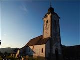
 | Bele Vode (Kovač) - Sveti Križ above Bele Vode (on south ridge)
Sveti Križ is a scenic mountain located above Beli Voda. From the top, which is home to a number of church buildings and a conversion tower, we h...
1 h 10 min |
 | Koprivna (Šumel) - Sveti Jakob in Koprivna
The Church of St James in Koprivna is situated on a lookout hill above the right bank of the Mež River. The church offers a beautiful view of Rad...
50 min |
 | Poljana - Smolnik
Smolnik is a steep 1075 m high peak - a solitary peak below Valvasor's house, rising above the Zavrh (Završnica) valley, with a view of Hochstuhl...
1 h 15 min |
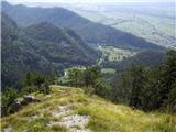 | Poljana - Smolnik (steep path)
Smolnik is a steep 1075 m high peak - a solitary peak below Valvasor's house, rising above the Zavrh (Završnica) valley, with a view of Hochstuhl...
1 h |
 | Dovje - Blažčeva skala (western path)
Blažčeva skala is a 1091-metre-high peak located north-east of Mojstrana and Dovje. From the top, which is known more by climbers than mountainee...
1 h |
 | Završnica (Pri žagi) - Smokuški vrh
Smokuški vrh is a scenic mountain located on a ridge between the Završnice valley and the Gorenjska plain. From the top of the hill, where there ...
1 h |
 | Završnica (Pri žagi) - Pleče
Pleče is a 1131-metre-high peak located north of St Peter above Begunje. The summit is covered by forest, but from near the top, we can enjoy som...
1 h 5 min |
 | Dom na Lazni - Stanov rob
A crest above Gorenja Trebuša, with a beautiful view....
1 h 10 min |
 | Koča na Pikovem - Jesenik (Jesenikov vrh)
Jesenik is a 1199 m high forested peak located between Mežica and Podpec....
1 h 5 min |
 | Matevljek - Petelinjek
Petelinjek is a 1212 m high peak located in the Racna Gora mountain range. There is no view from the summit, which is topped by a small metal cha...
1 h 15 min |
 | Dražgoše (Jelenšče) - Britmanca
...
50 min |
| Dražgoše (Na Pečeh) - Britmanca
...
1 h 10 min |
| Dražgoše (Jelenšče) - Britmanca (položna pot)
...
1 h 15 min |
 | Makekova Kočna - Turni
Turni is a lesser-known peak above the cliffs of the same name, which rise above Lake Planšar. From the summit, where the registration box is loc...
1 h |
 | Kajfežev rob - Kamniški vrh
Kamniški vrh is a 1259 m high mountain located north of Kamnik, between Stahovica and the Korošica Valley. From the top of the peak there is a sm...
1 h 15 min |
 | Makekova Kočna - Skubrov vrh
Skubrov vrh is a 1276 m high mountain rising steeply above the Ravena Koča valley. There is no view from the forested summit....
1 h 10 min |
 | Rotek - Erbelc
Erbelc is a 1308-metre-high peak rising steeply above Zgornja Sorica. From the summit, where the registration box is located, you can enjoy a bea...
1 h 15 min |
| Spodnje Danje - Erbelc
Erbelc is a 1308-metre-high peak rising steeply above Zgornja Sorica. From the summit, where the registration box is located, you can enjoy a bea...
1 h 15 min |
 | Planina pod Golico - Na pečeh pri Črnem Vrhu
On the Peaks is a lesser-known lookout peak with an altitude of 1318 metres, rising east above the village Mountain pasture below Kahlkogel. In t...
1 h 5 min |
 | Rotek - Tonderškofel
Tonderškofel is a 1326-metre high peak located between Soriška Peć and Erbellec. The partly overgrown peak, which has no marked trail, offers a b...
1 h 15 min |
| Spodnje Danje - Tonderškofel
Tonderškofel is a 1326-metre high peak located between Soriška Peć and Erbellec. The partly overgrown peak, which has no marked trail, offers a b...
1 h 15 min |
 | Planina pod Golico - Španov vrh
Španov vrh is a 1334m high mountain located between Javorniški Rovt and Mountain pasture below Golica. From the top, reached by the cable car of ...
1 h 15 min |
 | 2. serpentina vršiške ceste - Škrbinjek
...
1 h |
 | Koča na planini Kuhinja - Planica below Krn
Planica is a 1376 m high peak located south-west of Kren. The overgrown peak, which has two peaks of approximately the same height, offers a beau...
1 h 15 min |
 | Volovljek - Kranjska reber (on unmarked path)
Kranjska reber or Peak Kašna planina (1435 m) is a volcanic mountain. From the top, where the registration box with the stamp is located, we have...
1 h 15 min |
 | Erjavčev rovt - Bela peč (above Dovje)
Bele peči is a less known peak, located above the marked Dovje - Dovška Baba trail. The summit offers a beautiful view to the south and west, whi...
1 h 15 min |
 | Planina Lom - Kobilja glava
Kobilja glava is a 1475 m high peak located east of Tolmin. From the top with a cross, we have a beautiful view of the Krn, the Lower Bohinj Moun...
1 h 15 min |