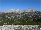
 | Planina Vetrh - Veliki Javornik (Ženiklovec)
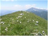
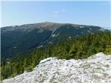
Veliki Javornik or Ženiklovec is a 1716 m high peak located between Storžič and Stegovnik. From the grassy summit, where the registration box is ...
1 h 30 min |
 | Planina Dol - Rzenik (west path)
Rzenik is a grassy peak surrounded by dwarf pines, which descends precipitously towards the Kamniška Bela valley. From the top, in fine weather, ...
1 h 40 min |
 | Planina Dol - Rzenik (east path)
Rzenik is a grassy peak surrounded by dwarf pines, which descends precipitously towards the Kamniška Bela valley. From the top, in fine weather, ...
1 h 40 min |
 | Vršič - Šitna glava
Šitna glava is a lesser-known mountain in the immediate vicinity of the besieged Mala Mojstrovka. From the top, which is covered with grass, ther...
1 h 20 min |
 | Bohinjsko sedlo - Slatnik (northwestern peak) (by Lajnar)
Slatnik is a scenic mountain located to the west of the Soriška mountain pasture ski resort. The grassy peak offers a beautiful view of the Škofj...
1 h 15 min |
 | Pod Krnico - Plešivec
Plešivec is an 1801 m high peak located south of the eastern part of Košuta. The summit, on which the border signpost stands, offers a beautiful ...
1 h 20 min |
 | Pod Krnico - Mala Košuta
Mala Košuta (German: Kleine Koschuta) is a 1740 m high peak located in the far east of Kosuta. The summit, which descends steeply towards Austria...
1 h 15 min |
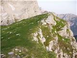
 | Planina Podvežak - Deska (Veža) (snowy approach)
Deska is a scenic peak located in the heart of the Dleskovška Plateau or Veža. From the top, where a large cairn stands, we have a beautiful view...
1 h 30 min |
 | Hunting cottage Na Brežičih - Deska (Veža)
Deska is a scenic peak located in the heart of the Dleskovška Plateau or Veža. From the top, where a large cairn stands, we have a beautiful view...
1 h 30 min |
 | Planina Podvežak - Deska (Veža)
Deska is a scenic peak located in the heart of the Dleskovška Plateau or Veža. From the top, where a large cairn stands, we have a beautiful view...
1 h 30 min |
 | Planina Podvežak - Tolsti vrh (Veža) (snowy approach)
Tolsti vrh is a 1985 m high mountain located in the heart of the Dleskovská Plateau - Veže. The summit, which is covered with dwarf pines, offers...
1 h 30 min |
 | Hunting cottage Na Brežičih - Tolsti vrh (Veža) (via Deska)
Tolsti vrh is a 1985 m high mountain located in the heart of the Dleskovská Plateau - Veže. The summit, which is covered with dwarf pines, offers...
1 h 45 min |
| Planina Podvežak - Tolsti vrh (Veža)
Tolsti vrh is a 1985 m high mountain located in the heart of the Dleskovská Plateau - Veže. The summit, which is covered with dwarf pines, offers...
1 h 30 min |
 | Planina Vetrh - Bela peč (via cottage Pr Zdravc)
The mountain, which is known mainly by climbers, is located north of Storžič on the slopes of Konjščice. From the top there is a beautiful view o...
1 h 15 min |
 | Železnica - Techantinger Mittagskogel (Trupejevo poldne)
The mountain is located on the border with Austria and is above Gozd Martuljko. From the uncultivated summit there is a beautiful view of Julian ...
1 h 15 min |
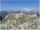
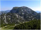
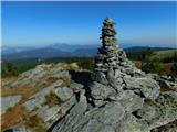
 | Planina Ravne - Dleskovec (by southern mountainside)
Dleskovec is a lookout mountain on the eastern side of the Dleskovská plateau. The plateau is named after Dleskovec. On the top of the peak stand...
1 h 40 min |
 | Koča na Gozdu - Vršič vrh (on old road)
Vršič is a 1737 m high mountain located between the Postman's House and the Vršič Pass. From the top, where the registration box is located, we h...
1 h 30 min |
 | Dom na Smrekovcu - Krnes (via Smrekovec)
The summit is located in the heart of the Smrekov Mountains and has a beautiful view. Peca, Uršlja gora and part of the highest peaks of the Savi...
1 h 35 min |
 | Zadnji travnik - Govca (Olševa) (hunting path)
Govca is the highest peak of the Olševa, a mountain range rising above Koprivna, Solčava and Remschenik (Remschenik / Remschenig is a valley on t...
1 h 45 min |
 | Planina Ravne - Križevnik
Križevnik is a scenic peak on the north-eastern edge of the Dleskov plateau. From this peak you can see across most of the plateau, where you can...
2 h |
 | Dolinza Alm / Planina Dolnica - Sagranberg/Monte Sagran
Sagranberg is a scenic mountain with no marked trail. The summit, which is grassy, descends precipitously southwards to the Italian side. From th...
1 h 30 min |
 | Jezero Sobote / Stausee Soboth - Huhnerkogel/Košenjak (po neoznačeni poti)
Huhnerkogel lies north of Dravograd and the River Drava on the border with neighbouring Austria. Huhnerkogel is accessible on foot or by car from...
1 h 40 min |
 | Planina Jezerca - Krvavec (on unmarked path via Razor)
Krvavec is an 1853 m high peak located in the heart of the ski resort of the same name. The summit, which is criss-crossed with cable cars, offer...
2 h |
 | Koča na Gozdu - Visoki Mavrinc
Visoki Mavrinc (Špica v Sedelcih) is a 1562 m high mountain located between Suha, Mala and Velika Pišnica. From the top of the peak, where there ...
1 h 15 min |
 | Erjavčeva koča na Vršiču - Prednje Robičje
Prednje Robičje is a 1941 m high mountain located in the mountain ridge between the valleys of Mala and Velika Pišnica. From the top of the summi...
1 h 10 min |
 | Križovec - Mala Golica
Mala Golica is a less distinct peak located east of Krvavka. From the grassy peak, we have a beautiful view of the Drava Valley, Barentaler Kotsc...
1 h 30 min |
 | Planina Loka - Kup (na Raduhi)
Jelovec is a 1808 m high peak located at the extreme north-eastern part of Raduha. From the top, on which the cross stands, we have a beautiful v...
1 h 20 min |
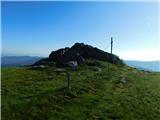
 | Pod Debelo glavo - Gradovec
Gradovec is a 1692 m high peak located north of the ridge of the Lower Bohinj Mountains, above mountain pasture Poljana. From the summit, where d...
1 h 35 min |
| Pod Debelo glavo - Gradovec (via hunting cottage)
Gradovec is a 1692 m high peak located north of the ridge of the Lower Bohinj Mountains, above mountain pasture Poljana. From the summit, where d...
1 h 50 min |
 | Topla (Končnik) - Šoparjev vrh
Šoparjev vrh is a 1524 m high mountain located between Olševa and Peca, more precisely on the ridge that separates the Koprivna valley from the T...
1 h 15 min |
| Koprivna (Kumer) - Šoparjev vrh
Šoparjev vrh is a 1524 m high mountain located between Olševa and Peca, more precisely on the ridge that separates the Koprivna valley from the T...
1 h 10 min |
| Pod Peco / Koprein-Petzen - Šoparjev vrh
Šoparjev vrh is a 1524 m high mountain located between Olševa and Peca, more precisely on the ridge that separates the Koprivna valley from the T...
1 h 35 min |
 | Koprivna (Kumer) - Čofatijev vrh (via Šoparjev vrh)
Čofatijev vrh is a lookout mountain between the valleys of Koprivna and Tople. From the top, you have a beautiful view of the mountains above bot...
1 h 45 min |
| Pod Peco / Koprein-Petzen - Čofatijev vrh (via Šoparjev vrh)
Čofatijev vrh is a lookout mountain between the valleys of Koprivna and Tople. From the top, you have a beautiful view of the mountains above bot...
2 h 10 min |
| Topla (Končnik) - Čofatijev vrh (via Šoparjev vrh)
Čofatijev vrh is a lookout mountain between the valleys of Koprivna and Tople. From the top, you have a beautiful view of the mountains above bot...
1 h 50 min |
 | Teichalm (Teichalmsee) - Zachenkreuz
Zachenkreuz is a 1601 m high peak located above the mountain pasture Teichalm. A wooden cross stands on the summit, which is mostly covered by a ...
1 h 20 min |
 | Feistritzsattel - Großer Pfaff (lažja pot)
...
1 h 45 min |
 | Feistritzsattel - Kleiner Pfaff
...
1 h 45 min |
 | parking below Weinebene - Moschkogel
...
1 h 40 min |
 | Feistritzsattel - Schöberlriegel
...
1 h 40 min |
 | Feistritzsattel - Umschussriegel
...
2 h |
 | Bürgeralm (Panoramastraße) - Hochstein (at Mitteralm) (čez Windgrube)
...
1 h 25 min |