 | Kozji hrbet - Možic
Možic is a 1602 m high peak located west of Soriška mountain pasture. It is at the highest point of the peak that there is an old military bunker...
1 h |
 | Volovljek - Kranjska reber (on unmarked path)
Kranjska reber or Peak Kašna planina (1435 m) is a volcanic mountain. From the top, where the registration box with the stamp is located, we have...
1 h 15 min |
 | Bohinjsko sedlo - Slatnik (northwestern peak) (direct way)
Slatnik is a scenic mountain located to the west of the Soriška mountain pasture ski resort. The grassy peak offers a beautiful view of the Škofj...
1 h |
| Bohinjsko sedlo - Slatnik (northwestern peak) (by Lajnar)
Slatnik is a scenic mountain located to the west of the Soriška mountain pasture ski resort. The grassy peak offers a beautiful view of the Škofj...
1 h 15 min |
 | Planina Vetrh - Bela peč (via cottage Pr Zdravc)
The mountain, which is known mainly by climbers, is located north of Storžič on the slopes of Konjščice. From the top there is a beautiful view o...
1 h 15 min |
 | Križovec - Ptičji vrh
Ptičji vrh is a 1550 m high mountain located between Barentaler Kotschna and Golica. The summit, which borders between Slovenia and Austria, offe...
1 h |
 | Kajfežev rob - Kamniški vrh
Kamniški vrh is a 1259 m high mountain located north of Kamnik, between Stahovica and the Korošica Valley. From the top of the peak there is a sm...
1 h 15 min |
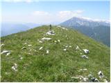
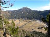
 | Planina Dol - Koritni vrh (Velika planina)
Koritni vrh is a 1648 m high mountain located in the northern part of Velika planina. From the top, on which stands a small cross, a beautiful vi...
1 h |
 | Bohinjsko sedlo - Lajnar (unmarked way)
Lajnar is a 1549 m high mountain located north of Soriška mountain pasture. From the top, which is also the highest point of the ski resort, we h...
45 min |
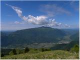
 | Kozji hrbet - Šavnik
Šavnik is a grassy peak located between the Soriška planina and Kobla ski resorts. From the summit, which has a registration box with a stamp, yo...
50 min |
 | Planina pod Golico - Španov vrh
Španov vrh is a 1334m high mountain located between Javorniški Rovt and Mountain pasture below Golica. From the top, reached by the cable car of ...
1 h 15 min |
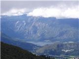
 | Planina Lom - Kobilja glava
Kobilja glava is a 1475 m high peak located east of Tolmin. From the top with a cross, we have a beautiful view of the Krn, the Lower Bohinj Moun...
1 h 15 min |
 | Koča na Gozdu - Visoki Mavrinc
Visoki Mavrinc (Špica v Sedelcih) is a 1562 m high mountain located between Suha, Mala and Velika Pišnica. From the top of the peak, where there ...
1 h 15 min |
 | Makekova Kočna - Skubrov vrh
Skubrov vrh is a 1276 m high mountain rising steeply above the Ravena Koča valley. There is no view from the forested summit....
1 h 10 min |
 | Makekova Kočna - Turni
Turni is a lesser-known peak above the cliffs of the same name, which rise above Lake Planšar. From the summit, where the registration box is loc...
1 h |
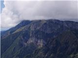
 | Koča na planini Kuhinja - Planica below Krn
Planica is a 1376 m high peak located south-west of Kren. The overgrown peak, which has two peaks of approximately the same height, offers a beau...
1 h 15 min |
 | Matevljek - Petelinjek
Petelinjek is a 1212 m high peak located in the Racna Gora mountain range. There is no view from the summit, which is topped by a small metal cha...
1 h 15 min |
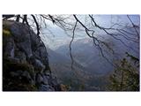 | Pri Žagi (Javorniški Rovt) - Velika Boncla
Velika Boncla is a 1241 m high, partly rocky peak located between Javorniški Rovt and mountain pasture Stamare in the Karavanke Mountains. The st...
1 h |
 | Rotek - Erbelc
Erbelc is a 1308-metre-high peak rising steeply above Zgornja Sorica. From the summit, where the registration box is located, you can enjoy a bea...
1 h 15 min |
| Spodnje Danje - Erbelc
Erbelc is a 1308-metre-high peak rising steeply above Zgornja Sorica. From the summit, where the registration box is located, you can enjoy a bea...
1 h 15 min |
 | Rotek - Tonderškofel
Tonderškofel is a 1326-metre high peak located between Soriška Peć and Erbellec. The partly overgrown peak, which has no marked trail, offers a b...
1 h 15 min |
| Spodnje Danje - Tonderškofel
Tonderškofel is a 1326-metre high peak located between Soriška Peć and Erbellec. The partly overgrown peak, which has no marked trail, offers a b...
1 h 15 min |
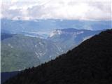
 | Planina pod Golico - Na pečeh pri Črnem Vrhu
On the Peaks is a lesser-known lookout peak with an altitude of 1318 metres, rising east above the village Mountain pasture below Kahlkogel. In t...
1 h 5 min |
 | Topla (Končnik) - Šoparjev vrh
Šoparjev vrh is a 1524 m high mountain located between Olševa and Peca, more precisely on the ridge that separates the Koprivna valley from the T...
1 h 15 min |
| Koprivna (Kumer) - Šoparjev vrh
Šoparjev vrh is a 1524 m high mountain located between Olševa and Peca, more precisely on the ridge that separates the Koprivna valley from the T...
1 h 10 min |
 | Bohinjsko sedlo - Črni vrh (above Soriška planina)
Črni vrh is a fairly scenic peak located above the Bohinjski Preval. From the partially vegetated summit or the surrounding area, we have a beaut...
1 h |
 | Ravne - Bela peč (above Dovje)
Bele peči is a less known peak, located above the marked Dovje - Dovška Baba trail. The summit offers a beautiful view to the south and west, whi...
45 min |
| Erjavčev rovt - Bela peč (above Dovje)
Bele peči is a less known peak, located above the marked Dovje - Dovška Baba trail. The summit offers a beautiful view to the south and west, whi...
1 h 15 min |
 | 2. serpentina vršiške ceste - Škrbinjek
...
1 h |
 | Dražgoše (Jelenšče) - Britmanca
...
50 min |
| Dražgoše (Jelenšče) - Britmanca (položna pot)
...
1 h 15 min |
 | Bürgeralm (Panoramastraße) - Schönleitenhaus (Windgrube) (po južnem grebenu)
...
50 min |