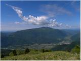
 | Kališe - Kranjska reber
Kranjska reber or Peak Kašna planina (1435 m) is a volcanic mountain. From the top, where the registration box with the stamp is located, we have...
1 h 30 min |
| Volovljek - Kranjska reber (on unmarked path)
Kranjska reber or Peak Kašna planina (1435 m) is a volcanic mountain. From the top, where the registration box with the stamp is located, we have...
1 h 15 min |
 | Kosmačev preval - Črna gora
The summit is located between the Kot and Vrata valleys. A bivouac with two beds is situated on the summit. The view is fine towards Kukova špica...
1 h 15 min |
 | Kajfežev rob - Kamniški vrh
Kamniški vrh is a 1259 m high mountain located north of Kamnik, between Stahovica and the Korošica Valley. From the top of the peak there is a sm...
1 h 15 min |
 | Preval Hlevišče - Koprivnik (via Brdo)
Koprivnik is a 1393 m high mountain located between Blegoš and Mladi vrh. The view from the summit, which has a registration box and a stamp, is ...
2 h |
 | Kozarnice - Srednji Golak (unmarked eastern way)
Srednji Golak is located between Mali and Veliki Golak on the plateau of the Trnovo Forest above Predmeja. The summit is covered with dwarf pines...
1 h 45 min |
 | Avsa - Mrzli vrh (on Matajur)
Mrzli vrh is a 1358-metre high peak located in the Matajur Mountains. From the top, where there is a viewing platform and a registration box with...
1 h 25 min |
 | Gorenje - Gora (Sveti Lovrenc) (gentle path)
Gora, or Sveti Lovrenc, is a peak above Studeni. It is a village north of Postojna, which is also a good starting point for climbing to the top o...
1 h 45 min |
 | Preval Hlevišče - Mladi vrh
Mladi vrh is the senior neighbour of the better known Stari vrh, from which it is separated by a saddle. The top is covered with a sparse beech f...
1 h 45 min |
 | Cenc - Špičasti vrh (on road over Novina)
Špičasti vrh is a forested mountain located south of the village of Zadlog. To ensure that the peak is not without a view, a 13m high wooden look...
1 h 30 min |
 | Dom Pristava in Javorniški Rovt - Španov vrh
Španov vrh is a 1334m high mountain located between Javorniški Rovt and Mountain pasture below Golica. From the top, reached by the cable car of ...
1 h 30 min |
| Planina pod Golico - Španov vrh
Španov vrh is a 1334m high mountain located between Javorniški Rovt and Mountain pasture below Golica. From the top, reached by the cable car of ...
1 h 15 min |
 | Planina Lom - Kobilja glava
Kobilja glava is a 1475 m high peak located east of Tolmin. From the top with a cross, we have a beautiful view of the Krn, the Lower Bohinj Moun...
1 h 15 min |
 | Koča na planini Stador - Jalovnik
Jalovnik is a grassy peak located southeast of the slightly higher Kobilje glave. From the summit, which has a registration box, we have a beauti...
1 h 30 min |
| Planina Lom - Jalovnik
Jalovnik is a grassy peak located southeast of the slightly higher Kobilje glave. From the summit, which has a registration box, we have a beauti...
1 h 30 min |
 | Koroška Bela (RC Kres) - Alničje (hunting path)
Alničje is a 1145 m high ridge rising from the SW above the settlements of Koroška bela and Javornik in Jesenik, and running NE in the direction ...
1 h 20 min |
 | Hunting cottage Vojkovo - Grmada (Nanos)
Grmada is a 1209 m high peak located to the north-west of the better known Plesa. From the summit, where there is a registration box with a stamp...
1 h 35 min |
 | Poljana - Smolnik
Smolnik is a steep 1075 m high peak - a solitary peak below Valvasor's house, rising above the Zavrh (Završnica) valley, with a view of Hochstuhl...
1 h 15 min |
 | Oblakov Vrh - Hudournik
Hudournik is a 1148 m high peak located on the northern edge of the Vojskar plateau, a plateau situated between the valleys of the Idrijca, Kanom...
1 h 30 min |
 | Makekova Kočna - Javornik above Jezersko
Javornik is a forested peak located between the valleys of Ravenna and Makekova Kočna. There is no view from the top due to the forest, but we ha...
1 h 45 min |
 | Makekova Kočna - Skubrov vrh
Skubrov vrh is a 1276 m high mountain rising steeply above the Ravena Koča valley. There is no view from the forested summit....
1 h 10 min |
 | Solarji - Kuk (Kolovrat)
At 1243 m, Kuk is the highest peak of the Kolovrat, the mountain range from Livko to Kambreški. The summit, which has several transmitters, offer...
2 h 10 min |
 | Koča na planini Kuhinja - Planica below Krn
Planica is a 1376 m high peak located south-west of Kren. The overgrown peak, which has two peaks of approximately the same height, offers a beau...
1 h 15 min |
 | Podmeja - Javor
Javor is a 1132 m high peak located between Kisovec and Sveta mountain pasture. There is no view from the top, which is covered with forest, but ...
2 h |
 | Matevljek - Petelinjek
Petelinjek is a 1212 m high peak located in the Racna Gora mountain range. There is no view from the summit, which is topped by a small metal cha...
1 h 15 min |
 | Rotek - Erbelc
Erbelc is a 1308-metre-high peak rising steeply above Zgornja Sorica. From the summit, where the registration box is located, you can enjoy a bea...
1 h 15 min |
| Spodnje Danje - Erbelc
Erbelc is a 1308-metre-high peak rising steeply above Zgornja Sorica. From the summit, where the registration box is located, you can enjoy a bea...
1 h 15 min |
 | Rotek - Tonderškofel
Tonderškofel is a 1326-metre high peak located between Soriška Peć and Erbellec. The partly overgrown peak, which has no marked trail, offers a b...
1 h 15 min |
| Spodnje Danje - Tonderškofel
Tonderškofel is a 1326-metre high peak located between Soriška Peć and Erbellec. The partly overgrown peak, which has no marked trail, offers a b...
1 h 15 min |
 | Jeršiče - Baba (at Javorniki)
Baba is a 1085 m high peak located between the Javorniki Ridge and Sveta Trojica. From the grassy summit, we have a beautiful view of the Javorni...
1 h 30 min |
 | Možjanca - Kopa (Partizanski vrh)
Kopa, also Partizanski vrh, is a 1024-metre high mountain located west of the Davovec saddle, which is west to south-west of Krvavec. There is a ...
1 h 30 min |
 | Bele Vode (Kovač) - Sveti Križ above Bele Vode (on south ridge)
Sveti Križ is a scenic mountain located above Beli Voda. From the top, which is home to a number of church buildings and a conversion tower, we h...
1 h 10 min |
 | Tolminske Ravne - Javor (above Tolminske Ravne)
Javor is a 1363 m high peak located between Tolminske Ravne and Grušnica. From the top, on which a small cross is erected, you can enjoy a beauti...
1 h 20 min |
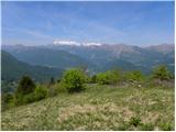
 | Polja - Kališje
Kališje is a lesser-known peak in the western part of the Karavanke Mountains. From the summit, where the transmitters are located, we have some ...
1 h 40 min |
 | Bela Peč - Ojstri vrh (above Prevala) (past peak Seduc)
Ojstri vrh is a 1,197-metre-high mountain located between Seduc Peak and Prevala. From the top, you can enjoy a beautiful view of the surrounding...
1 h 30 min |
 | Bela Peč - Ojstri vrh (above Prevala) (via Ovčje jame)
Ojstri vrh is a 1,197-metre-high mountain located between Seduc Peak and Prevala. From the top, you can enjoy a beautiful view of the surrounding...
1 h 45 min |
 | Poljšica pri Gorjah (Zatrata) - Hotunjski vrh (on footpath)
Hotunjski vrh is a 1107-metre-high lookout peak located above the Zatrnik ski resort. From the top, where there is a registration box and a bench...
1 h 30 min |
| Poljšica pri Gorjah (Zatrata) - Hotunjski vrh (by road)
Hotunjski vrh is a 1107-metre-high lookout peak located above the Zatrnik ski resort. From the top, where there is a registration box and a bench...
2 h |
 | Podblica - Bela peč (Podbliška gora)
Bela peč is located on the edge of Jelovica above the village of Podblica. From the top of the cliff we have a beautiful view of the village, the...
1 h 30 min |
 | Sveta Jedert (Lajše) - Bela peč (Podbliška gora) (via Rigli)
Bela peč is located on the edge of Jelovica above the village of Podblica. From the top of the cliff we have a beautiful view of the village, the...
1 h 30 min |
| Sveta Jedert (Lajše) - Bela peč (Podbliška gora) (upper part on the road)
Bela peč is located on the edge of Jelovica above the village of Podblica. From the top of the cliff we have a beautiful view of the village, the...
1 h 30 min |
 | Šumahovo sedlo - Jesenik (Jesenikov vrh) (via Veliki and Pikov vrh)
Jesenik is a 1199 m high forested peak located between Mežica and Podpec....
1 h 45 min |
 | Koča na Pikovem - Šumahov vrh (via Pikov and Veliki vrh)
Šumahov vrh is a 1155-metre-high peak on which a wooden cross is erected. From the top, which descends steeply towards Žerjav, we have a beautifu...
1 h 35 min |
 | Završnica (Pri žagi) - Tolsti vrh (at Poljška planina) (via saddle Kališča)
Tolsti vrh is a 1,225-metre-high peak located between the Završnice valley and the Draga valley. The peak is located in a forest, but from the lo...
1 h 25 min |
 | Apno - Prgozdnik (Martinova pot)
Prgozdnik is a 1013-metre-high peak located on the ridge of the same name, between the settlements of Ambrož pod Krvavcem, Šenturška Gora, Apno a...
1 h 10 min |
 | Žabnica / Bodental - Veliki Rob / Großer Rain
Veliki Rob is a 1464 m high peak located on the Austrian side of Karawanks, in the ridge above the Poden / Bodental valley. The summit has been o...
1 h 50 min |
| Žabnica / Bodental - Veliki Rob / Großer Rain (via Veronjak / Hausberg)
Veliki Rob is a 1464 m high peak located on the Austrian side of Karawanks, in the ridge above the Poden / Bodental valley. The summit has been o...
2 h 10 min |
 | Žabnica / Bodental - Veronjak / Hausberg
Veronjak is a 1348 m high peak located above the Poden / Bodental valley on the Austrian side of the Karavanke. From the top, where there is a sm...
1 h 20 min |
| Slovenji Plajberk / Windisch Bleiberg - Veronjak / Hausberg (via Veronjak / Hausberg)
Veronjak is a 1348 m high peak located above the Poden / Bodental valley on the Austrian side of the Karavanke. From the top, where there is a sm...
1 h 25 min |
 | Slovenji Plajberk / Windisch Bleiberg - Rabenberg
Rabenberg is a 1465 m high peak located in the Singerberg / Singerberg ridge. The summit offers some views to the north-west, but the view is blo...
1 h 45 min |
| Plajberški graben / Bleiberger Graben - Rabenberg
Rabenberg is a 1465 m high peak located in the Singerberg / Singerberg ridge. The summit offers some views to the north-west, but the view is blo...
1 h 45 min |
 | Medvodje - Penatca
Penatca is a 1299 m high peak located above the right bank of the Tržiška Bistrica. The peak itself is located in a forest, and a few steps west ...
1 h 40 min |
 | MHE Zali potok - Primožkovi hribi
Primožkovi hribi is a small ridge above Jelendol, located between the watercourses of the Tržiška Bistrica, Dolžanka and Zalega potok. The highes...
1 h 30 min |
 | Medvodje - Medvodnica (via Tržiška Bistrica)
Medvodnica is a 1202 metre high mountain located between the Košutna and Tržiška Bistrica watercourses. The peak is located in a forest, so there...
1 h 30 min |
| Medvodje - Medvodnica (via Košutnik)
Medvodnica is a 1202 metre high mountain located between the Košutna and Tržiška Bistrica watercourses. The peak is located in a forest, so there...
1 h 25 min |
 | Erjavčev rovt - Bela peč (above Dovje)
Bele peči is a less known peak, located above the marked Dovje - Dovška Baba trail. The summit offers a beautiful view to the south and west, whi...
1 h 15 min |
 | Schrems/Frohnleiten (Hautabauer) - Harterberg (Hoaterberg)
...
2 h |