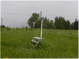
 | Topol - Sveti Jakob
The Church of St James is located on a hill north of the village of Topol near Medvode. From the top, where there is a registration box with a st...
40 min |
| Topol - Sveti Jakob (via homestead Na Vihri)
The Church of St James is located on a hill north of the village of Topol near Medvode. From the top, where there is a registration box with a st...
45 min |
 | Zamlake - Krim
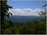
Krim is a 1107 m high mountain rising south of the Ljubljana Marshes. From the top of the mountain, where the mountain lodge and a number of tran...
50 min |
 | Javornik - Sveti Jošt above Kranj
Sveti Jošt above Kranj, is a hill located to the west of the slightly lower Šmarjetna Gora. From the top, where the Church of St. Jošto and the J...
40 min |
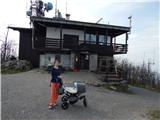
 | Dom na Govejku - Osolnik
Osolnik is an 858 m high mountain located south of Škofja Loka and west of Medvode. From the top, where the Church of St. Mohor and Fortunatus st...
1 h |
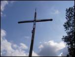 | Topol - Jeterbenk
Jeterbenk is a 774 m high peak located between Slavko's home at Gole Brdo and Katarina (Topol village). From the top, where there is a large cros...
45 min |
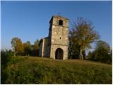
 | Čepulje - Archangel Gabriel (Planica)
Planica is an 824 m high peak located north of Škofja Loka, between Krizna Gora and Planica. From the top, where the Church of St. Gabriel the Ar...
50 min |
 | Smrečje - Vrh Svetih Treh Kraljev (by road)
The Church of the Holy Three Kings is situated on a lookout above the village of Vrh Svetih Treh kraljev. From the top, which has an observation ...
45 min |
 | Smrečje - Vrh Svetih Treh Kraljev (footpath)
The Church of the Holy Three Kings is situated on a lookout above the village of Vrh Svetih Treh kraljev. From the top, which has an observation ...
40 min |
| Smrečje - Vrh Svetih Treh Kraljev (via Jereb)
The Church of the Holy Three Kings is situated on a lookout above the village of Vrh Svetih Treh kraljev. From the top, which has an observation ...
45 min |
| Račevsko jezero - Vrh Svetih Treh Kraljev
The Church of the Holy Three Kings is situated on a lookout above the village of Vrh Svetih Treh kraljev. From the top, which has an observation ...
45 min |
 | Zaplana (St. Urh and St. Martin) - Ulovka
Ulovka is the peak between Zaplana and the Shelter at Mountain pasture above Vrhnika. From the top, which is reached by ski lifts, there is a nic...
50 min |
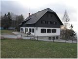 | Zagreben (pri Dikcu) - Dom na Šmohorju
Dom na Šmohorju is located between Laško, Liboje and Zabukovica. From the house, or from the Church of St. Mohorj, a few minutes away, there is a...
45 min |
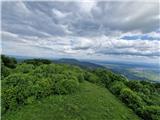
 | Travna Gora - Koča na Kamnem griču
The cottage is located on Kamný hill, a scenic peak rising south-west of Sodražica. The grassy summit, surrounded by forest, offers a beautiful v...
45 min |
 | Leskovec - Obolno
Obolno is a 776m high peak located south-west of the village of the same name. The grassy summit, next to which the radio club hut stands, offers...
1 h |
 | Kamen - Mokrc
Mokrc on maps Mokrec is a 1059 m high mountain located to the east of Iškega Vintgar. The summit is forested and therefore has no view. For some ...
40 min |
 | Smrečje - Lavrovec
Lavrovec is an 890 m high peak located between Horjul and Žirmi. From the top, where the solar irradiance meter is located (official measuring po...
40 min |
 | Belo - Goljek
Goljek is an 809 m high peak located east of Polhograjska Grmada. The view from the summit, which is home to the remains of a former watchtower o...
40 min |
 | Čepulje - Špičasti hrib
Špičasti hrib (Špičasti vrh on maps) is an 837 m high peak located to the west of Sveti Jošto above Kranj. There is no view from the top, which h...
40 min |
 | Predmeja - Dolski maj (Pot po Robu)
Dolski maj (also Predmeja May) is a 912 m high peak located on the edge of Gora, more precisely between Predmeja and Otlica. From the top, where ...
1 h |
 | Otlica - Dolski maj
Dolski maj (also Predmeja May) is a 912 m high peak located on the edge of Gora, more precisely between Predmeja and Otlica. From the top, where ...
1 h |
 | Mrše - Sveti Socerb (Artviže)
The Church of St. Socerbo is situated on a hill overloking the village of Artviže, which is the highest peak in Brkina with its 817 m. The church...
1 h |
 | Podlanišče - Veliki vrh (Lajše)
Veliki vrh is an almost 900 m high peak rising south of Cerkno. From the top, where there are several television and radio transmitters covering ...
40 min |
 | Hunting sports association Vinska Gora - Vinska gora
Vinska gora, marked on some maps as neighbouring Temnjak, is an 806 m high hill located north-west of Dobrnež and north-east of Vinská Gora. The ...
40 min |
 | Solarji - Ježa
Ježa is a 949 m high peak located west of Volč, on the slopes of Kolovrat. From the top, where there is a registration box with a registration bo...
45 min |
 | Planinski dom pod Ježo - Deveti konfin (survey point 930)
Očna is a 906 m high peak located in the Kolovrat mountain range, west of Tolmina. From the meadow a few metres away from the summit, we have a b...
55 min |
 | Solarji - Deveti konfin (survey point 942) (via Ježa)
Deveti konfin is a 930 m high peak in the Kolovrat mountain range, located between Ježa and Očno. There is no view from the summit, where a small...
1 h 10 min |
| Planinski dom pod Ježo - Deveti konfin (survey point 942)
Deveti konfin is a 930 m high peak in the Kolovrat mountain range, located between Ježa and Očno. There is no view from the summit, where a small...
45 min |
 | Črne njive - Ahac
Ahac or St. Ahac is a 799 m high peak located east of Ilirska Bistrica. The summit, which is home to a registration box, a cross and the ruins of...
40 min |
 | Vrbiški dol - Ahac
Ahac or St. Ahac is a 799 m high peak located east of Ilirska Bistrica. The summit, which is home to a registration box, a cross and the ruins of...
1 h |
 | Župeno - Sveti Vid (Vidovska planota)
Sveti Vid is a small village in the middle of the Vidovska Plateau, a plateau located between Menišija and the upper reaches of the valley of the...
1 h 10 min |
 | Dragonoš (Krpesovka) - Japetić
Japetić is the highest peak of the Samobor Mountains. It is located in its western part and is the house mountain of the town of Jastebarsko. On ...
45 min |
 | Cenc - Špiček (Špečk)
Špiček (locals call it Špečk) is a peak located north to north-east of Cola. On the summit is a cross in honour of St Hubert and commemorating th...
45 min |
 | Ledinsko Razpotje - Sveta Marija Magdalena (Gore) (east path)
The Church of St Mary Magdalene is situated on a hill above the settlement Gore, which is above Idrija. From the church or its immediate surround...
1 h |
| Ledinsko Razpotje - Sveta Marija Magdalena (Gore) (west path)
The Church of St Mary Magdalene is situated on a hill above the settlement Gore, which is above Idrija. From the church or its immediate surround...
1 h 10 min |
 | Škalske Cirkovce - Lubela (by road)
Lubela is a hill at Velenje, rising north above the Šaleška dolina and belonging to the Šentviška hills or the wider area of the Graška Gora.On t...
45 min |
| Stružnica - Kuželjska stena
Kuželjska stena rises majestically above the village of Kuželj in the Kolpa valley. It is a rise in a fault that winds above the upper Kolpa vall...
45 min |
 | Smiljan - Krčmar (on marked path)
...
40 min |
 | Rašpor - Gradina Rašpor (on marked path)
...
45 min |
 | Rašpor - Marećica
...
1 h |