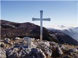
 | Mesnice - Krim (by road)
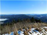
Krim is a 1107 m high mountain rising south of the Ljubljana Marshes. From the top of the mountain, where the mountain lodge and a number of tran...
1 h 50 min |
 | Rakitna - Krim
Krim is a 1107 m high mountain rising south of the Ljubljana Marshes. From the top of the mountain, where the mountain lodge and a number of tran...
2 h |
 | Polharski dom Krim - Krim
Krim is a 1107 m high mountain rising south of the Ljubljana Marshes. From the top of the mountain, where the mountain lodge and a number of tran...
1 h 35 min |
 | Korensko sedlo - Ofen/Peč
Peč (also Tromeja), in Italian Monte Forno and in German Dreiländereck or Ofen, is a 1508 m high peak located on the tri-border between Slovenia,...
2 h |
 | Korensko sedlo - Ofen/Peč (on marked path)
Peč (also Tromeja), in Italian Monte Forno and in German Dreiländereck or Ofen, is a 1508 m high peak located on the tri-border between Slovenia,...
2 h |
 | Dom pod Storžičem - Bela peč
The mountain, which is known mainly by climbers, is located north of Storžič on the slopes of Konjščice. From the top there is a beautiful view o...
2 h |
 | Bohinjsko sedlo - Šavnik (by Lajnar)
Šavnik is a grassy peak located between the Soriška planina and Kobla ski resorts. From the summit, which has a registration box with a stamp, yo...
2 h |
 | Hunting cottage Vojkovo - Vojkova koča na Nanosu
Vojkova koča is located on the southern edge of the Nanoše plateau, close to Pleše, a peak that is clearly visible from the motorway. From the hu...
1 h 45 min |
 | Furlanovo zavetišče pri Abramu - Vojkova koča na Nanosu
Vojkova koča is located on the southern edge of the Nanoše plateau, close to Pleše, a peak that is clearly visible from the motorway. From the hu...
2 h |
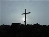
 | Predmeja - Kucelj na Čavnu (by road)
Kucelj is located on the southern slopes of Trnovo Forest, north-west of the Vipava valley. From the uncultivated summit on which the cross stand...
1 h 45 min |
 | Predmeja - Kucelj na Čavnu
Kucelj is located on the southern slopes of Trnovo Forest, north-west of the Vipava valley. From the uncultivated summit on which the cross stand...
2 h |
 | Krnica - Kucelj na Čavnu (via Veliki Rob)
Kucelj is located on the southern slopes of Trnovo Forest, north-west of the Vipava valley. From the uncultivated summit on which the cross stand...
1 h 40 min |
 | Predmeja - Veliki Modrasovec
Veliki Modrasovec is located in the southern part of the Trnovo Forest near Predmeja. On the top of the hill is an old military building which yo...
1 h 35 min |
 | Škrbina - Mali Golak
Mali Golak is the highest of the Golaks. It was named not because it was the smallest but because it had the smallest mountain pasture. On the ma...
2 h |
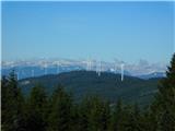
 | Koča na Klopnem vrhu - Rogla
Rogla is the peak in the middle of the ski resort of the same name. The summit is woded with a small clearing on which stands a lookout tower. Th...
2 h 45 min |
 | Dom na Paškem Kozjaku - Basališče (Paški Kozjak)
Basališče is the highest peak of Paško Kozjak. There is a bench and a registration box at the top. Due to the forest, there is no view....
2 h |
 | Kampelc - Javornik above Črni vrh
Javornik is a forested peak located southeast of Črnji Vrho. In 1972, a lookout tower was erected on the summit, which reaches above the treetops...
2 h 15 min |
 | Repna dolina - Javornik above Črni vrh
Javornik is a forested peak located southeast of Črnji Vrho. In 1972, a lookout tower was erected on the summit, which reaches above the treetops...
1 h 45 min |
 | Platak - Vidikovac
Vidikovac is a 1408m high peak in the Gorski Kotar. From the partially uncultivated summit there is a very nice view of the nearby Veliki Risnjak...
2 h 45 min |
 | Dom na Osankarici - Klopni vrh (eastern path)
Klopni vrh encloses the lower lying extensive plateau in the eastern Pohorje Mountains from the north-west. The area of the horizontal section at...
2 h 45 min |
| Koča na Šumiku - Klopni vrh (eastern path)
Klopni vrh encloses the lower lying extensive plateau in the eastern Pohorje Mountains from the north-west. The area of the horizontal section at...
2 h |
 | Koča na Šumiku - Klopni vrh (northern path)
Klopni vrh encloses the lower lying extensive plateau in the eastern Pohorje Mountains from the north-west. The area of the horizontal section at...
2 h |
 | Dom na Čreti - Tolsti vrh (Dobrovlje)
Tolsti vrh is, together with Šentjoški vrh (1077m), the highest peak of the Dobrovelj Plateau. The view from the summit, which has a registration...
1 h 45 min |
 | Zagrad - Medvižica (via Ostrič)
Medvižica is a rocky peak located on the Slovenian side of Čičaria. From the uncultivated summit you can enjoy a beautiful view of the surroundin...
1 h 45 min |
 | Strma Reber - Cerk
At 1192 m, Cerk is the highest peak of Borovška Gora, a mountain range located between the Kolpa River valley and Goteniškje Snežnik. From the to...
1 h 45 min |
 | Solarji - Nagnoj
At 1193 m, Nagnoj is the second highest peak of the Kolovrat, a mountain range located between Tolmin and Venetian Slovenia. From the top, where ...
1 h 40 min |
 | Bohinjsko sedlo - Kačji rob (Ovharn)
Kačji rob is a 1520 m high peak located between mountain pasture Zgornji Jirn and the lesser known peak Žbanjek. The summit, which bears the Rati...
2 h |
| Soriška peč - Kačji rob (Ovharn)
Kačji rob is a 1520 m high peak located between mountain pasture Zgornji Jirn and the lesser known peak Žbanjek. The summit, which bears the Rati...
2 h 30 min |
 | St. John the Baptist on Ojstrica - Kozji vrh (at Košenjak)
Kozji vrh is a 1383-metre-high peak located above Pernice, and its height makes it the highest peak in the municipality of Muta....
1 h 35 min |
 | Chortata - Egklouvi road - Stavrota (Lefkada)
Stavrota or Elati mountain is a 1182 m high mountain on the Greek island Lefkada. The island, which lies in Ionian sea, is also known as Lefkas o...
1 h 50 min |
 | Koča na Klopnem vrhu - Pesek
Pesek is a 1423 m high peak on Pohorje, located above Koča na Pesku....
2 h 23 min |
 | Koča na Šumiku - Veliki vrh (on Pohorje)
Veliki vrh is a 1344-metre-high peak located above the RTC Jakec - Trije kralji ski resort. The highest point of the peak is located in the fores...
2 h |
 | Teichalm (Teichalmsee) - Rote Wand (spodnja pot)
Rote Wand is a 1505 m high mountain in the Graz mountain range in Styria, Austria. It is named "Rote Wand" (red wall) after the southeast-facing ...
2 h 15 min |
| Teichalm (Teichalmsee) - Rote Wand (zgornja pot)
Rote Wand is a 1505 m high mountain in the Graz mountain range in Styria, Austria. It is named "Rote Wand" (red wall) after the southeast-facing ...
2 h 15 min |
 | Mönichkirchen - Steinerne Stiege
Steinerne Stiege is a less prominent peak in the Wechsell mountain range....
1 h 35 min |
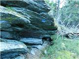
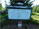
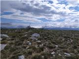
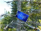 | Feistritzsattel - Grabmayr-Kogel
...
1 h 40 min |
 | St. Vinzenz (St. Vinzenz) - Dreieckkogel
...
1 h 35 min |
 | Planinski dom Orlove stine - Svilaja (mimo Umaca)
...
2 h |
 | Malovan - Čardak (Tremzina)
...
2 h |
 | Malovan - Oklinak
...
2 h 30 min |
 | Alpl (Zisleranger Weg) - Teufelstein
...
2 h 20 min |
| Alpl (Zisleranger Weg) - Teufelstein (mimo koče Edelweißhütte)
...
2 h 40 min |
 | Nechnitz - Gerlerkogel (čez Gschaidberg)
...
2 h 15 min |
 | Teichalm (Harrerhütte) - Osser
...
1 h 35 min |
 | Straßegg - Hochschlag
...
1 h 45 min |
 | Zeller Kreuz - Stanglalpe
...
2 h 50 min |
| Schanzsattel - Stanglalpe
...
2 h 20 min |
 | Omar - Črni vrh (nad Klenovico)
...
1 h 45 min |