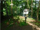
 | Gabrje - Polhograjska Grmada
Polhograjska Grmada is an 898 m high peak located in the heart of the Polhograjski Dolomiti. The summit, which has a registration box with a stam...
2 h 20 min |
 | Braslovško jezero - Grmada (Dobrovlje)
Grmada is an 898 m high forested peak located in the south-eastern part of the Dobrovlje plateau. The summit, on which the stamp is located, is n...
2 h 25 min |
 | Brezno - Sveti Pankracij (Radelca) (by Remšniški potok)
The Church of St Pancras on Radelca is located on the border ridge between Slovenia and Austria, but since 1966, following an inter-state agreeme...
2 h 50 min |
 | Divje jezero - Hleviška planina (via Prižnica)
Hleviška planina (also Hleviška planina) is a slightly overgrown but still very scenic peak. From the top, which is the house mountain of Idrija,...
2 h 30 min |
 | Puščava - Hlebov vrh (Rdeči Breg)
The Red Bank stretches between the Radoljna Gorge in the east, the Drava River in the north and the Velka Stream in the east. It is separated fro...
2 h 55 min |
| HE Ožbalt - Hlebov vrh (Rdeči Breg)
The Red Bank stretches between the Radoljna Gorge in the east, the Drava River in the north and the Velka Stream in the east. It is separated fro...
2 h 50 min |
 | Jelovec - Žavcarjev vrh
Žavcarjev vrh is a 915m high mountain located north of the River Drava on the slopes of Kozjak. As the peak is completely overgrown, there is no ...
2 h 25 min |
 | Vuhred - Janževski vrh
Janževski vrh is a 915-metre-high mountain located above the right bank of the Drava River and the left bank of the Velka Stream. At the top is t...
4 h |
 | Kozje - Debeli vrh (Bohor) (via Vetrnik)
Debeli vrh is a 921-metre-high peak on Bohor between Veliki Koprivnik and Oslice. It is overgrown with dense forest, so there are no views. There...
2 h 35 min |
 | Podgorje ob Sevnični (Kurja vas) - Ješivec
...
2 h 45 min |
 | Vuzenica - Sedovnikov vrh
...
2 h 35 min |
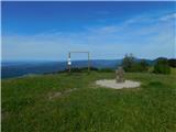 | Podgorje ob Sevnični (Kurja vas) - Lisca
Lisca is a scenic peak located north of Sevnica. From the top of the peak, where the meteorological radar station stands, there is a beautiful vi...
3 h 40 min |
 | Podgorje ob Sevnični (Kurja vas) - Skalica (Bohor)
Skalica is a less known peak in the western part of Bohor. From the summit, which has a registration box, there is a beautiful view to the south ...
2 h 20 min |
 | Radeče - Nebeška gora
Nebeška gora is the highest peak of the municipality of Radeče on the Sava River. There is a registration book and a stamp on the top, as well as...
2 h 45 min |
| Zidani Most - Nebeška gora (vzhodna pot)
Nebeška gora is the highest peak of the municipality of Radeče on the Sava River. There is a registration book and a stamp on the top, as well as...
2 h 40 min |
| Zidani Most - Nebeška gora (zahodna pot)
Nebeška gora is the highest peak of the municipality of Radeče on the Sava River. There is a registration book and a stamp on the top, as well as...
2 h 45 min |
 | Nakovana - Sveti Ilija (Pelješac)
Sv. Ilija, also known as Zmija's Bumblebee, is a 961-metre-high mountain and the highest peak on the Pelješac peninsula. From the top, you can en...
2 h 45 min |
 | Ožbalt - Sršenov vrh
Sršenov vrh is a 963-metre-high peak located in the Kozjak Mountains, specifically between Ožbalt and Zgornja Kapla. The peak itself does not off...
2 h 45 min |
 | Lesično - Koprivnik (Bohor)
Koprivnik or Veliki Koprivnik is one of the many peaks in Bohor. It is located between Koča na Bohorju and Veliki Koprivnik. From the top of the ...
3 h 15 min |
 | Kozje - Koprivnik (Bohor) (via Vetrnik)
Koprivnik or Veliki Koprivnik is one of the many peaks in Bohor. It is located between Koča na Bohorju and Veliki Koprivnik. From the top of the ...
3 h 10 min |
 | Podgorje ob Sevnični (Kurja vas) - Koprivnik (Bohor)
Koprivnik or Veliki Koprivnik is one of the many peaks in Bohor. It is located between Koča na Bohorju and Veliki Koprivnik. From the top of the ...
3 h 15 min |
 | Hrastnik - Kal (Kalski hrib) (via Klobuk)
Kal is a 985m high peak located between the more famous Mrzlica and the lesser known Klobuk. From the top where the bench stands, there is no bet...
2 h 25 min |
| Hrastnik - Kal (Kalski hrib) (via Ravne)
Kal is a 985m high peak located between the more famous Mrzlica and the lesser known Klobuk. From the top where the bench stands, there is no bet...
2 h 25 min |
 | Hrastnik - Kal (Kalski hrib) (via Blate)
Kal is a 985m high peak located between the more famous Mrzlica and the lesser known Klobuk. From the top where the bench stands, there is no bet...
2 h 20 min |
 | Zidani Most - Veliko Kozje
Veliko Kozje is a peak located west of Zidanega Most. From the summit, which has a registration box, there is a beautiful view of Zasavska and Po...
2 h 30 min |
 | Jamce - Sinji vrh (eastern path via Škraplje)
Sinji vrh is a scenic mountain located between Col, Ajdovščina and Predmeja. From the top, you can enjoy a beautiful view over most of western Sl...
2 h 55 min |
 | Cerkno - Štor (via Kladje)
Štor is a 1005 m high peak located directly above the Ermanovec Cottage. The peak itself is covered with forest, but from the meadow, which is on...
2 h 40 min |
| Cerkno - Štor (via Planina pri Cerknem)
Štor is a 1005 m high peak located directly above the Ermanovec Cottage. The peak itself is covered with forest, but from the meadow, which is on...
2 h 45 min |
 | Matrafüred - Kékestető (red path via Peresberc in Negyeshatar)
Matra is a mountain range located 70 km east of Budapest. The two highest peaks in Hungary are Kékestető, which is the highest peak in Hungary at...
2 h 45 min |
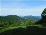
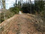
 | Gabrje - Tošč
Tošč, which became the highest peak of Polhograjsko hribovje decades ago when Pasja ravan was lowered by 9 m by the Yugoslav army, is located nor...
3 h 5 min |
 | Kozje - Veliki Javornik (Bohor) (via Koprivnik)
Veliki Javornik is the highest peak of Bohor at 1023m. Although the peak is unspoilt and there are no higher hills far around, there is no view f...
2 h 45 min |
 | Podgorje ob Sevnični (Kurja vas) - Veliki Javornik (Bohor)
Veliki Javornik is the highest peak of Bohor at 1023m. Although the peak is unspoilt and there are no higher hills far around, there is no view f...
2 h 40 min |
 | Cerkno - Ermanovec (via Kladje)
Ermanovec is a 1026 m high peak located between Cerkno and Gorenjska vasja, specifically above Sovodnje and Trebija. Just a few steps away from t...
2 h 55 min |
| Cerkno - Ermanovec (via Planina pri Cerknem)
Ermanovec is a 1026 m high peak located between Cerkno and Gorenjska vasja, specifically above Sovodnje and Trebija. Just a few steps away from t...
3 h |
 | Cerkno - Bevkov vrh
Bevkov vrh, which is a point on the Slovenian mountain trail, is located between Cerkno and Spodnja Idrija. The summit is covered with forest and...
2 h 50 min |
| Straža - Želin - Bevkov vrh
Bevkov vrh, which is a point on the Slovenian mountain trail, is located between Cerkno and Spodnja Idrija. The summit is covered with forest and...
2 h 45 min |
 | Brezno - Kapunar / Kapunerkogel (along Remšniški potok)
Kapunar is a 1051 m high peak above Radlje ob Dravi. Just below the peak is an old caravan and border guardhouse, which is now used by radio amat...
3 h 35 min |
 | Zidani Most - Sveta Marija (Ključevica)
The Church of St Mary is located on a hill called Ključevica, which rises 1067 metres above sea level. From the top, which is partly covered with...
2 h 30 min |
| Radeče - Sveta Marija (Ključevica)
The Church of St Mary is located on a hill called Ključevica, which rises 1067 metres above sea level. From the top, which is partly covered with...
3 h 10 min |
| Dolina Sopote (Zagrad) - Sveta Marija (Ključevica)
The Church of St Mary is located on a hill called Ključevica, which rises 1067 metres above sea level. From the top, which is partly covered with...
2 h 35 min |
 | Straža - Vrhovec
Vrhovec 1079 m (also Lokvarski vrh) high grassy peak located south of the Šebrelje plateau. From the top, where there is a panoramic signboard, y...
3 h 30 min |
 | Marija Reka (Koritnikov most) - Homič (po gozdni vlaki)
...
2 h 30 min |
| Marija Reka (Koritnikov most) - Homič (čez Kriško planino)
...
2 h 40 min |
 | Spodnja Rečica - Gozdnik (via Tolsto)
Gozdnik is a hill rising steeply above the village of Zabukovica. There is no view from the top, due to the forest, but there is a bivouac on it,...
3 h 20 min |
| Laško - Gozdnik
Gozdnik is a hill rising steeply above the village of Zabukovica. There is no view from the top, due to the forest, but there is a bivouac on it,...
3 h 45 min |
| Zgornja Rečica (cerkev bl. Antona Martina Slomška) - Gozdnik
Gozdnik is a hill rising steeply above the village of Zabukovica. There is no view from the top, due to the forest, but there is a bivouac on it,...
3 h 25 min |
 | Jezero - Krim (via Ledenica)
Krim is a 1107 m high mountain rising south of the Ljubljana Marshes. From the top of the mountain, where the mountain lodge and a number of tran...
2 h 30 min |
 | Jezero - Krim (via homestead Špelin)
Krim is a 1107 m high mountain rising south of the Ljubljana Marshes. From the top of the mountain, where the mountain lodge and a number of tran...
2 h 20 min |
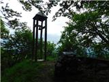
 | Fram - Mariborski razglednik (Cigelnica) (via Petkovo sedlo)
Mariborski razglednik) is a 1147 m high peak located next to the Maribor Pohorje ski resort. A lookout tower stands at the top, offering a beauti...
3 h 25 min |
| Spodnje Radvanje - Mariborski razglednik (Cigelnica) (po SPP)
Mariborski razglednik) is a 1147 m high peak located next to the Maribor Pohorje ski resort. A lookout tower stands at the top, offering a beauti...
2 h 25 min |
 | Srednja Kanomlja - Hudournik
Hudournik is a 1148 m high peak located on the northern edge of the Vojskar plateau, a plateau situated between the valleys of the Idrijca, Kanom...
3 h 45 min |
 | Vuzenica - Kremžarjev vrh
Kremžarjev vrh is the westernmost millennium on Pohorje. It is located north-east of Slovenj Gradec. There is no view from the summit, which has ...
3 h 50 min |
 | Fram - Ledinekov kogel (čez Petkovo sedlo, vzhodna pot)
Ledinekov kogel is a 1182 m high peak located north of Maribor hut. Just below the summit is a fenced area with a radar tower....
3 h 25 min |
 | Fram - Ledinekov kogel (čez Petkovo sedlo, zahodna pot)
Ledinekov kogel is a 1182 m high peak located north of Maribor hut. Just below the summit is a fenced area with a radar tower....
3 h 30 min |
| Spodnje Radvanje - Ledinekov kogel (po SPP)
Ledinekov kogel is a 1182 m high peak located north of Maribor hut. Just below the summit is a fenced area with a radar tower....
2 h 40 min |
 | Osilnica - Cerk
At 1192 m, Cerk is the highest peak of Borovška Gora, a mountain range located between the Kolpa River valley and Goteniškje Snežnik. From the to...
4 h 5 min |
 | Trbovlje - Črni vrh (Čemšeniška planina)
Črni vrh is the highest peak of Čemšeniška mountain pasture and with a height of 1204 m it is the second highest peak in the Posavje - Zasavje hi...
4 h |
 | Izlake - Črni vrh (Čemšeniška planina)
Črni vrh is the highest peak of Čemšeniška mountain pasture and with a height of 1204 m it is the second highest peak in the Posavje - Zasavje hi...
3 h |
| Izlake - Črni vrh (Čemšeniška planina) (via Razbor pri Čemšeniku)
Črni vrh is the highest peak of Čemšeniška mountain pasture and with a height of 1204 m it is the second highest peak in the Posavje - Zasavje hi...
3 h 10 min |
| Kisovec - Črni vrh (Čemšeniška planina)
Črni vrh is the highest peak of Čemšeniška mountain pasture and with a height of 1204 m it is the second highest peak in the Posavje - Zasavje hi...
3 h 40 min |
| Zagorje ob Savi - Črni vrh (Čemšeniška planina)
Črni vrh is the highest peak of Čemšeniška mountain pasture and with a height of 1204 m it is the second highest peak in the Posavje - Zasavje hi...
4 h 5 min |
 | Trbovlje - Kum (via Čebulova dolina)
At 1220 metres, Kum is the highest peak of Posavsko hribovje. Because it rises above Zasavje, some people call it the Zasavje Triglav. On the sum...
3 h 30 min |
 | Zidani Most - Kum (through Škratova dolina (old path))
At 1220 metres, Kum is the highest peak of Posavsko hribovje. Because it rises above Zasavje, some people call it the Zasavje Triglav. On the sum...
3 h |
 | Hrastnik (Podkraj) - Kum (via Matca)
At 1220 metres, Kum is the highest peak of Posavsko hribovje. Because it rises above Zasavje, some people call it the Zasavje Triglav. On the sum...
2 h 55 min |
| Zidani Most - Kum (through Škratova dolina (new path))
At 1220 metres, Kum is the highest peak of Posavsko hribovje. Because it rises above Zasavje, some people call it the Zasavje Triglav. On the sum...
3 h 5 min |
| Radeče - Kum
At 1220 metres, Kum is the highest peak of Posavsko hribovje. Because it rises above Zasavje, some people call it the Zasavje Triglav. On the sum...
3 h 45 min |
| Dolina Sopote (Zagrad) - Kum
At 1220 metres, Kum is the highest peak of Posavsko hribovje. Because it rises above Zasavje, some people call it the Zasavje Triglav. On the sum...
3 h 10 min |
 | Kamnje - Kucelj na Čavnu
Kucelj is located on the southern slopes of Trnovo Forest, north-west of the Vipava valley. From the uncultivated summit on which the cross stand...
2 h 45 min |
 | Stomaž - Kucelj na Čavnu
Kucelj is located on the southern slopes of Trnovo Forest, north-west of the Vipava valley. From the uncultivated summit on which the cross stand...
3 h |
 | Gojače - Kucelj na Čavnu
Kucelj is located on the southern slopes of Trnovo Forest, north-west of the Vipava valley. From the uncultivated summit on which the cross stand...
2 h 55 min |
 | Vrtovin - Kucelj na Čavnu (via Koča na Mali gori)
Kucelj is located on the southern slopes of Trnovo Forest, north-west of the Vipava valley. From the uncultivated summit on which the cross stand...
3 h |
 | Gojače - Veliki Rob
Veliki Rob is a scenic peak located between Kuclje (1237m) and Čavno (1185m). From the summit on which the cross is located, there is a beautiful...
3 h 30 min |
| Vrtovin - Veliki Rob
Veliki Rob is a scenic peak located between Kuclje (1237m) and Čavno (1185m). From the summit on which the cross is located, there is a beautiful...
2 h 50 min |
 | Vitovlje - Veliki Rob (via Vitovlje Lake and over Sekulak)
Veliki Rob is a scenic peak located between Kuclje (1237m) and Čavno (1185m). From the summit on which the cross is located, there is a beautiful...
3 h 10 min |
 | Lozice - Vojkova koča na Nanosu
Vojkova koča is located on the southern edge of the Nanoše plateau, close to Pleše, a peak that is clearly visible from the motorway. From the hu...
2 h 45 min |
| Hrašče - Vojkova koča na Nanosu (via Brižnik)
Vojkova koča is located on the southern edge of the Nanoše plateau, close to Pleše, a peak that is clearly visible from the motorway. From the hu...
3 h |
| Hrašče - Vojkova koča na Nanosu (past troughs)
Vojkova koča is located on the southern edge of the Nanoše plateau, close to Pleše, a peak that is clearly visible from the motorway. From the hu...
3 h |
| Gradišče - Vojkova koča na Nanosu (via Sveti Miklavž)
Vojkova koča is located on the southern edge of the Nanoše plateau, close to Pleše, a peak that is clearly visible from the motorway. From the hu...
3 h 45 min |
 | Gornja Brela (Subotišće) - Bukovac
...
2 h 30 min |
 | Lozice - Suhi vrh (Nanos) (steep path)
At 1313m, Suhi vrh is the highest peak of the karst plateau of Nanos. From the summit, which has a registration box and a stamp (the stamp is cur...
4 h 10 min |
 | Ruše - Klopni vrh (severna pot)
Klopni vrh encloses the lower lying extensive plateau in the eastern Pohorje Mountains from the north-west. The area of the horizontal section at...
3 h 40 min |
| Ruše - Klopni vrh (vzhodna pot)
Klopni vrh encloses the lower lying extensive plateau in the eastern Pohorje Mountains from the north-west. The area of the horizontal section at...
3 h 55 min |
 | Zgornja Bistrica (Center Vintgar) - Veliki vrh (on Pohorje) (via Veliko Tinje)
Veliki vrh is a 1344-metre-high peak located above the RTC Jakec - Trije kralji ski resort. The highest point of the peak is located in the fores...
3 h 50 min |
| Zgornja Bistrica (Center Vintgar) - Veliki vrh (on Pohorje) (via Bistriški vintgar)
Veliki vrh is a 1344-metre-high peak located above the RTC Jakec - Trije kralji ski resort. The highest point of the peak is located in the fores...
3 h 45 min |
 | Ruše - Žigartov vrh
At 1346m, Žigartov vrh is the highest peak in the eastern part of Pohorje. An "observation" tower used to stand on the summit, but was erected on...
3 h 15 min |