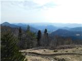
 | Preserje - Krim
Krim is a 1107 m high mountain rising south of the Ljubljana Marshes. From the top of the mountain, where the mountain lodge and a number of tran...
2 h 20 min |
| Jezero - Krim (via Ledenica)
Krim is a 1107 m high mountain rising south of the Ljubljana Marshes. From the top of the mountain, where the mountain lodge and a number of tran...
2 h 30 min |
 | Jezero - Krim (via homestead Špelin)
Krim is a 1107 m high mountain rising south of the Ljubljana Marshes. From the top of the mountain, where the mountain lodge and a number of tran...
2 h 20 min |
 | Trbovlje - Kum (via Čebulova dolina)
At 1220 metres, Kum is the highest peak of Posavsko hribovje. Because it rises above Zasavje, some people call it the Zasavje Triglav. On the sum...
3 h 30 min |
 | Dolina Sopote (Zagrad) - Kum
At 1220 metres, Kum is the highest peak of Posavsko hribovje. Because it rises above Zasavje, some people call it the Zasavje Triglav. On the sum...
3 h 10 min |
 | Lozice - Vojkova koča na Nanosu
Vojkova koča is located on the southern edge of the Nanoše plateau, close to Pleše, a peak that is clearly visible from the motorway. From the hu...
2 h 45 min |
| Hrašče - Vojkova koča na Nanosu (via Brižnik)
Vojkova koča is located on the southern edge of the Nanoše plateau, close to Pleše, a peak that is clearly visible from the motorway. From the hu...
3 h |
| Hrašče - Vojkova koča na Nanosu (past troughs)
Vojkova koča is located on the southern edge of the Nanoše plateau, close to Pleše, a peak that is clearly visible from the motorway. From the hu...
3 h |
| Gradišče - Vojkova koča na Nanosu (via Sveti Miklavž)
Vojkova koča is located on the southern edge of the Nanoše plateau, close to Pleše, a peak that is clearly visible from the motorway. From the hu...
3 h 45 min |
 | Kamnje - Kucelj na Čavnu
Kucelj is located on the southern slopes of Trnovo Forest, north-west of the Vipava valley. From the uncultivated summit on which the cross stand...
2 h 45 min |
 | Stomaž - Kucelj na Čavnu
Kucelj is located on the southern slopes of Trnovo Forest, north-west of the Vipava valley. From the uncultivated summit on which the cross stand...
3 h |
 | Vrtovin - Kucelj na Čavnu (via Koča na Mali gori)
Kucelj is located on the southern slopes of Trnovo Forest, north-west of the Vipava valley. From the uncultivated summit on which the cross stand...
3 h |
 | Kamnje - Veliki Modrasovec
Veliki Modrasovec is located in the southern part of the Trnovo Forest near Predmeja. On the top of the hill is an old military building which yo...
2 h 50 min |
| Stomaž - Veliki Modrasovec
Veliki Modrasovec is located in the southern part of the Trnovo Forest near Predmeja. On the top of the hill is an old military building which yo...
2 h 35 min |
| Vrtovin - Veliki Modrasovec
Veliki Modrasovec is located in the southern part of the Trnovo Forest near Predmeja. On the top of the hill is an old military building which yo...
3 h 5 min |
 | Zreče (church of St. Egidij) - Rogla (via Gorenje)
Rogla is the peak in the middle of the ski resort of the same name. The summit is woded with a small clearing on which stands a lookout tower. Th...
3 h 50 min |
 | Hrastnik - Mrzlica (via Klobuk)
Mrzlica has become an extremely popular excursion point in the last few years, especially for visitors from the Savinjska Valley and Zasavje. At ...
3 h 5 min |
| Hrastnik - Mrzlica (via Ravne)
Mrzlica has become an extremely popular excursion point in the last few years, especially for visitors from the Savinjska Valley and Zasavje. At ...
3 h 5 min |
 | Trbovlje - Mrzlica
Mrzlica has become an extremely popular excursion point in the last few years, especially for visitors from the Savinjska Valley and Zasavje. At ...
2 h 30 min |
 | Dol pri Hrastniku - Mrzlica
Mrzlica has become an extremely popular excursion point in the last few years, especially for visitors from the Savinjska Valley and Zasavje. At ...
2 h 50 min |
| Hrastnik - Mrzlica (via Blate)
Mrzlica has become an extremely popular excursion point in the last few years, especially for visitors from the Savinjska Valley and Zasavje. At ...
3 h |
 | Prebold - Mrzlica (po gozdni vlaki)
Mrzlica has become an extremely popular excursion point in the last few years, especially for visitors from the Savinjska Valley and Zasavje. At ...
3 h 10 min |
| Prebold - Mrzlica (via Kriška planina)
Mrzlica has become an extremely popular excursion point in the last few years, especially for visitors from the Savinjska Valley and Zasavje. At ...
3 h 20 min |
| Marija Reka (Koritnikov most) - Mrzlica (po gozdni vlaki)
Mrzlica has become an extremely popular excursion point in the last few years, especially for visitors from the Savinjska Valley and Zasavje. At ...
2 h 45 min |
| Marija Reka (Koritnikov most) - Mrzlica (čez Kriško planino)
Mrzlica has become an extremely popular excursion point in the last few years, especially for visitors from the Savinjska Valley and Zasavje. At ...
2 h 55 min |
 | Dravograd - Huhnerkogel/Košenjak (via Ojstrica)
Huhnerkogel lies north of Dravograd and the River Drava on the border with neighbouring Austria. Huhnerkogel is accessible on foot or by car from...
3 h 15 min |
 | Dravograd - Huhnerkogel/Košenjak (via Goriški Vrh)
Huhnerkogel lies north of Dravograd and the River Drava on the border with neighbouring Austria. Huhnerkogel is accessible on foot or by car from...
3 h |
 | Lavamünd - Huhnerkogel/Košenjak
Huhnerkogel lies north of Dravograd and the River Drava on the border with neighbouring Austria. Huhnerkogel is accessible on foot or by car from...
4 h |
 | Vuzenica - Kremžarjev vrh
Kremžarjev vrh is the westernmost millennium on Pohorje. It is located north-east of Slovenj Gradec. There is no view from the summit, which has ...
3 h 50 min |
 | Dolina Zaplaninščice - Črni vrh (Čemšeniška planina)
Črni vrh is the highest peak of Čemšeniška mountain pasture and with a height of 1204 m it is the second highest peak in the Posavje - Zasavje hi...
2 h 30 min |
 | Loke - Črni vrh (Čemšeniška planina) (via Zajčeva koča)
Črni vrh is the highest peak of Čemšeniška mountain pasture and with a height of 1204 m it is the second highest peak in the Posavje - Zasavje hi...
3 h 35 min |
| Trbovlje - Črni vrh (Čemšeniška planina)
Črni vrh is the highest peak of Čemšeniška mountain pasture and with a height of 1204 m it is the second highest peak in the Posavje - Zasavje hi...
4 h |
 | Izlake - Črni vrh (Čemšeniška planina)
Črni vrh is the highest peak of Čemšeniška mountain pasture and with a height of 1204 m it is the second highest peak in the Posavje - Zasavje hi...
3 h |
| Izlake - Črni vrh (Čemšeniška planina) (via Razbor pri Čemšeniku)
Črni vrh is the highest peak of Čemšeniška mountain pasture and with a height of 1204 m it is the second highest peak in the Posavje - Zasavje hi...
3 h 10 min |
| Kisovec - Črni vrh (Čemšeniška planina)
Črni vrh is the highest peak of Čemšeniška mountain pasture and with a height of 1204 m it is the second highest peak in the Posavje - Zasavje hi...
3 h 40 min |
| Zagorje ob Savi - Črni vrh (Čemšeniška planina)
Črni vrh is the highest peak of Čemšeniška mountain pasture and with a height of 1204 m it is the second highest peak in the Posavje - Zasavje hi...
4 h 5 min |
 | Spodnja Rečica - Gozdnik (via Tolsto)
Gozdnik is a hill rising steeply above the village of Zabukovica. There is no view from the top, due to the forest, but there is a bivouac on it,...
3 h 20 min |
| Laško - Gozdnik
Gozdnik is a hill rising steeply above the village of Zabukovica. There is no view from the top, due to the forest, but there is a bivouac on it,...
3 h 45 min |
| Zgornja Rečica (cerkev bl. Antona Martina Slomška) - Gozdnik
Gozdnik is a hill rising steeply above the village of Zabukovica. There is no view from the top, due to the forest, but there is a bivouac on it,...
3 h 25 min |
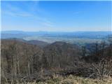
 | Log - Mariborski razglednik (Cigelnica)
Mariborski razglednik) is a 1147 m high peak located next to the Maribor Pohorje ski resort. A lookout tower stands at the top, offering a beauti...
2 h 50 min |
| Pivola (Reka) - Mariborski razglednik (Cigelnica) (via Petkovo sedlo)
Mariborski razglednik) is a 1147 m high peak located next to the Maribor Pohorje ski resort. A lookout tower stands at the top, offering a beauti...
2 h 40 min |
| Fram - Mariborski razglednik (Cigelnica) (via Petkovo sedlo)
Mariborski razglednik) is a 1147 m high peak located next to the Maribor Pohorje ski resort. A lookout tower stands at the top, offering a beauti...
3 h 25 min |
| Spodnje Radvanje - Mariborski razglednik (Cigelnica) (po SPP)
Mariborski razglednik) is a 1147 m high peak located next to the Maribor Pohorje ski resort. A lookout tower stands at the top, offering a beauti...
2 h 25 min |
 | Kotišina - Vošac
Vošac is a 1422m high peak located on the south side of Biokovo above Makarska. From the summit, on which the mountain lodge stands, there is a v...
3 h |
 | Ruše - Klopni vrh (severna pot)
Klopni vrh encloses the lower lying extensive plateau in the eastern Pohorje Mountains from the north-west. The area of the horizontal section at...
3 h 40 min |
| Ruše - Klopni vrh (vzhodna pot)
Klopni vrh encloses the lower lying extensive plateau in the eastern Pohorje Mountains from the north-west. The area of the horizontal section at...
3 h 55 min |
 | Reka - Kojca
Kojca is a scenic peak rising south of Baška Grape. The hay pile on the top offers a beautiful view of the Lower Bohinj Mountains, the Škofjelošk...
3 h 55 min |
 | Kokarje (ŠRC Laze) - Tolsti vrh (Dobrovlje) (via Dom na Farbanci)
Tolsti vrh is, together with Šentjoški vrh (1077m), the highest peak of the Dobrovelj Plateau. The view from the summit, which has a registration...
3 h 15 min |
| Potok (Mostni graben) - Tolsti vrh (Dobrovlje) (via Dom na Farbanci)
Tolsti vrh is, together with Šentjoški vrh (1077m), the highest peak of the Dobrovelj Plateau. The view from the summit, which has a registration...
2 h 50 min |
 | Vitovlje - Veliki Rob
Veliki Rob is a scenic peak located between Kuclje (1237m) and Čavno (1185m). From the summit on which the cross is located, there is a beautiful...
3 h |
 | Vrtovin - Veliki Rob
Veliki Rob is a scenic peak located between Kuclje (1237m) and Čavno (1185m). From the summit on which the cross is located, there is a beautiful...
2 h 50 min |
| Vitovlje - Veliki Rob (via Vitovlje Lake and over Sekulak)
Veliki Rob is a scenic peak located between Kuclje (1237m) and Čavno (1185m). From the summit on which the cross is located, there is a beautiful...
3 h 10 min |
 | Lozice - Suhi vrh (Nanos) (steep path)
At 1313m, Suhi vrh is the highest peak of the karst plateau of Nanos. From the summit, which has a registration box and a stamp (the stamp is cur...
4 h 10 min |
 | Osilnica - Cerk
At 1192 m, Cerk is the highest peak of Borovška Gora, a mountain range located between the Kolpa River valley and Goteniškje Snežnik. From the to...
4 h 5 min |
 | Srednja Kanomlja - Hudournik
Hudournik is a 1148 m high peak located on the northern edge of the Vojskar plateau, a plateau situated between the valleys of the Idrijca, Kanom...
3 h 45 min |
 | Cerkno - Medrce (via Labinjske lehe)
Medrce is a 1410 m high peak located between Porezno and Hum. From the top, where the old bunker is located, we have a beautiful view of Kojca, P...
3 h 25 min |
 | Straža - Vrhovec
Vrhovec 1079 m (also Lokvarski vrh) high grassy peak located south of the Šebrelje plateau. From the top, where there is a panoramic signboard, y...
3 h 30 min |
 | Muta (Zgornja Muta) - Kozji vrh (at Košenjak)
Kozji vrh is a 1383-metre-high peak located above Pernice, and its height makes it the highest peak in the municipality of Muta....
3 h 45 min |
 | Bordano - Monte San Simeone
Monte San Simeone is a mountain in the south-eastern part of the Carniola Fothills, a fine lookout over the Tilment River, which here passes from...
3 h 45 min |
 | Oplotnica - Veliki vrh (on Pohorje)
Veliki vrh is a 1344-metre-high peak located above the RTC Jakec - Trije kralji ski resort. The highest point of the peak is located in the fores...
3 h 15 min |
| Zgornja Bistrica (Center Vintgar) - Veliki vrh (on Pohorje) (via Veliko Tinje)
Veliki vrh is a 1344-metre-high peak located above the RTC Jakec - Trije kralji ski resort. The highest point of the peak is located in the fores...
3 h 50 min |
| Zgornja Bistrica (Center Vintgar) - Veliki vrh (on Pohorje) (via Bistriški vintgar)
Veliki vrh is a 1344-metre-high peak located above the RTC Jakec - Trije kralji ski resort. The highest point of the peak is located in the fores...
3 h 45 min |
 | Log - Ledinekov kogel
Ledinekov kogel is a 1182 m high peak located north of Maribor hut. Just below the summit is a fenced area with a radar tower....
2 h 40 min |
 | Pivola (Reka) - Ledinekov kogel (vzhodna pot)
Ledinekov kogel is a 1182 m high peak located north of Maribor hut. Just below the summit is a fenced area with a radar tower....
2 h 40 min |
| Pivola (Reka) - Ledinekov kogel (zahodna pot)
Ledinekov kogel is a 1182 m high peak located north of Maribor hut. Just below the summit is a fenced area with a radar tower....
2 h 45 min |
| Fram - Ledinekov kogel (čez Petkovo sedlo, vzhodna pot)
Ledinekov kogel is a 1182 m high peak located north of Maribor hut. Just below the summit is a fenced area with a radar tower....
3 h 25 min |
| Fram - Ledinekov kogel (čez Petkovo sedlo, zahodna pot)
Ledinekov kogel is a 1182 m high peak located north of Maribor hut. Just below the summit is a fenced area with a radar tower....
3 h 30 min |
| Spodnje Radvanje - Ledinekov kogel (po SPP)
Ledinekov kogel is a 1182 m high peak located north of Maribor hut. Just below the summit is a fenced area with a radar tower....
2 h 40 min |
 | Gornja Brela (Subotišće) - Bukovac
...
2 h 30 min |
 | Prebold - Homič (po gozdni vlaki)
...
2 h 55 min |
| Prebold - Homič (via Kriška planina)
...
3 h 5 min |
| Marija Reka (Koritnikov most) - Homič (po gozdni vlaki)
...
2 h 30 min |
| Marija Reka (Koritnikov most) - Homič (čez Kriško planino)
...
2 h 40 min |