 | Draga - Dobrča (via Ledena trata)
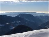
Dobrča is a 1634 m high mountain located between Begunje and Tržič. From the top, where the registration box with the stamp is located, we can se...
3 h |
 | Hudi Graben - Dobrča (via Lešanska planina)
Dobrča is a 1634 m high mountain located between Begunje and Tržič. From the top, where the registration box with the stamp is located, we can se...
2 h 35 min |
| Hudi Graben - Dobrča
Dobrča is a 1634 m high mountain located between Begunje and Tržič. From the top, where the registration box with the stamp is located, we can se...
2 h 30 min |
 | Volaka - Blegoš (on unmarked path)
Blegoš is a 1562 m high mountain located between Selška and Poljane Sora. From the grassy summit, on which there is a stamp and a registration bo...
2 h 35 min |
 | Potoče - Javorov vrh (via Sveti Jakob, below Potoška gora and over Baba)
Javorov vrh (also Javorjev vrh according to some records) is a 1434 m high mountain located northeast of Preddvor. From the top, which has a regi...
2 h 55 min |
| Spodnja Kokra - Javorov vrh (via Baba)
Javorov vrh (also Javorjev vrh according to some records) is a 1434 m high mountain located northeast of Preddvor. From the top, which has a regi...
2 h 30 min |
 | Mače - Bašeljski vrh (via valley of Suha and via Kališče)
Bašeljski vrh is a 1744 m high mountain located between Mali Grintovec and Storžič. From the top, where there is a bench and a registration box w...
3 h 15 min |
 | Rosenbach - Klek
Klek is a 1753 m high mountain located between Rosenkogel and the more famous Golica. The summit, which borders between Slovenia and Austria, off...
3 h 40 min |
 | Kraljev hrib - Koritni vrh (Velika planina)
Koritni vrh is a 1648 m high mountain located in the northern part of Velika planina. From the top, on which stands a small cross, a beautiful vi...
3 h |
 | Češnjice v Tuhinju - Vivodnik
At 1508 m, Vivodnik is the highest peak of the Menina mountain pasture, a plateau rising south of Gornji Grad. From the top, where there is a sma...
2 h 25 min |
 | Source of Ljubija - Smrekovec (via Leskovškova pustota)
Smrekovec is a volcanic mountain on the eastern edge of the Smrekov Mountains. The extensive grassy summit, on which stands a pyramid with a regi...
2 h 20 min |
| Source of Ljubija - Smrekovec (by road)
Smrekovec is a volcanic mountain on the eastern edge of the Smrekov Mountains. The extensive grassy summit, on which stands a pyramid with a regi...
2 h 30 min |
 | Ivarčko jezero - Uršlja gora (Plešivec) (Grofovska pot)
Uršlja gora or Plešivec is a lookout mountain between Slovenj Gradec and Črna na Koroškem. On the top or just below it stands the Church of St Ur...
2 h 50 min |
 | Bohinjska Bistrica - Krevl (on ski track)
Krevl is a 1515 m high peak located to the south of the Kobla ski area, more precisely between Koble Peak and Kravje Črna Gora. From the summit, ...
2 h 45 min |
 | Podljubelj / Unterloibl - Singerberg / Žingarica
Singerberg is a peak located on the Austrian side of Karawanks above the village of Slovenji Plajberk / Windisch Bleiberg. The summit, which is p...
3 h |
 | Bled (Velika Zaka) - Galetovec
Galetovec is an undistinguished peak in the south-eastern part of the Pokljuka plateau. From the summit, which has a registration box, there is a...
3 h 35 min |
| Poljšica pri Gorjah (Zatrata) - Galetovec (on footpath)
Galetovec is an undistinguished peak in the south-eastern part of the Pokljuka plateau. From the summit, which has a registration box, there is a...
2 h 35 min |
 | Draga - Šentanski vrh (via Ledena trata)
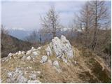
Šentanski vrh, located in the Dobrča mountain range, only 5 minutes away from the main peak, offers a beautiful view of the central Karawanks, th...
3 h 5 min |
 | Hudi Graben - Šentanski vrh (via Lešanska planina)
Šentanski vrh, located in the Dobrča mountain range, only 5 minutes away from the main peak, offers a beautiful view of the central Karawanks, th...
2 h 40 min |
| Hudi Graben - Šentanski vrh
Šentanski vrh, located in the Dobrča mountain range, only 5 minutes away from the main peak, offers a beautiful view of the central Karawanks, th...
2 h 35 min |
 | Vitovlje - Čaven
Čaven is a forested peak located west of Veliki Rob (1237m). The peak, which has a very well-known name, is not reached by any marked trail, alth...
2 h 30 min |
 | Jesenice (Straža) - Španov vrh (via Jelenkamen)
Španov vrh is a 1334m high mountain located between Javorniški Rovt and Mountain pasture below Golica. From the top, reached by the cable car of ...
2 h 30 min |
 | Zalog - Grebenc
Grebenc is a lesser-known peak, rising steeply above Malo and Velika Poljana. From this little visited peak, in good weather we can enjoy a beaut...
2 h 20 min |
 | Radovna - Vošni vrh
Vošni vrh is a 1621 metre high mountain located in the ridge of mountains starting at Radovna and ending at Tosc. The peak itself is located in a...
3 h |
 | Ribčev Laz - Hunting cottage Na Glinu
Hunting cottage Na Glinu is located on a lookout between the mountains Suha and Poljana. The hut offers a beautiful view of Triglav and most of t...
3 h 30 min |
 | Bled (Velika Zaka) - Turn (above Bohinjska Bela)
Turn is a scenic and precipitous peak located above Bohinjska Bela. From the top you can enjoy a beautiful view of Ratitovec, Jelovica, Kamnik Sa...
3 h 15 min |
 | Rebrca / Rechberg - Stara gora / Altberg (via Bukovnik)
Stara gora is a 1552 m high peak located north-east of Hochobir, the highest peak of the Obir. A wooden cross and a bench are placed on the summi...
2 h 50 min |
| Rebrca / Rechberg - Stara gora / Altberg (via Rokov vrh)
Stara gora is a 1552 m high peak located north-east of Hochobir, the highest peak of the Obir. A wooden cross and a bench are placed on the summi...
3 h 10 min |
 | Sele-Zvrhnji Kot (Male) / Zell-Oberwinkel (Male) - Hajnžev Praprotnik / Zeller Prapotnik
Hajnžev Praprotnik is a 1727 m high peak located on the Austrian side of Karawanks, more precisely between Loibler Baba and the village of Sele-Z...
3 h 55 min |
 | Leše - Hom (above Prevalje) (via Kot pri Prevaljah)
Hom is a 1193 m high peak located between Uršlja gora and Prevalje. On the top there is a registration box with a registration book, but the view...
2 h 40 min |
| Prevalje - Hom (above Prevalje)
Hom is a 1193 m high peak located between Uršlja gora and Prevalje. On the top there is a registration box with a registration book, but the view...
3 h |
 | Tržič - Robič (via Kamnek and Zavetišče na Kalu)
Robič is a 1384 m high peak located between the valley of Tržiška Bistrica and the ridge of Košuta. The summit offers a beautiful view, especiall...
3 h 35 min |
| Tržič (Čegelše) - Robič (via Zavetišče na Kalu)
Robič is a 1384 m high peak located between the valley of Tržiška Bistrica and the ridge of Košuta. The summit offers a beautiful view, especiall...
2 h 55 min |
 | Činžat - Lamprehtov vrh
Lamprehtov vrh is a 1230 m high peak on Pohorje, located north-east of Klopni vrh....
2 h 30 min |
 | Veliko Tinje - Veliki vrh (on Pohorje) (via Sveti Urh)
Veliki vrh is a 1344-metre-high peak located above the RTC Jakec - Trije kralji ski resort. The highest point of the peak is located in the fores...
2 h 55 min |
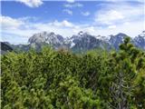 | Spodnja Trenta - Na Glavi
Na Glavi or Na Glavi is a 1666-metre-high peak above Stari Utr. From the top, which is covered with dwarf pines, there is a very beautiful view o...
3 h 25 min |
 | Mixnitz (Parkirišče Bärenschützklamm) - Ranerwand
...
2 h 30 min |