 | Pernica - Vavtošek
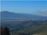
Vavtošek is a scenic summit in the Slovenske Gorice on which several transmitters stand. From the top there is a fine view mainly towards the sou...
1 h 5 min |
 | Lokvica - Fajti hrib
Fajti, also known in some records as Fajtji hrib, is a 433-meter-high hill located in the Črni hribi ridge. The summit is known mainly for the fi...
1 h |
 | Phliški bajer - Mengeška koča on Gobavica (ridge path)
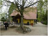
Gobavica is a hill rising above Mengeš. Mengeška koča mountain hut stands on it, along with a goat pen. It is one of the starting points for the ...
1 h 10 min |
 | Laško (cemetery Laško) - Church of St. Michael at Šmihel (past Sveti Krištof)
The Church of St. Michael at Šmihel is situated on a scenic hill above Laško. From the church, beautiful views open up to Veliko Kozje, Kopitnik,...
52 min |
 | Ljubljana (Gruberjeva brv) - Mazovnik (Golovec)
Mazovnik, at 450 m, is the highest peak of Golovec, a hill range located on the southeastern outskirts of Ljubljana. Golovec remained bare until ...
1 h |
 | Ljubljana (Žabja vas) - Orle
Orle is a settlement in the Municipality of Škofljica, located on a small hill northeast of the Ljubljana Marshes. A few meters below the highest...
1 h 15 min |
 | Stainz bei Straden - Rosenberg
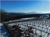
Rosenberg is a panoramic peak located south of the Aussichtswarte Vulkanland observation tower, or just slightly above the settlement of Rožni Vr...
1 h 10 min |
 | Lokvica - Veliki vrh (Črni hribi)
Veliki vrh is a 463-meter-high hill located in the Črni hribi ridge. From the summit, which has a summit logbox, there is no view due to the fore...
1 h 30 min |
 | Dragomer - Strmca (via Debeli hrib)
Strmca is a lesser-known forested hill located between the settlements of Brezje pri Dobrovi and Log pri Brezovici. Due to the forest cover, ther...
1 h 15 min |
 | Stainz bei Straden - Aussichtswarte Vulkanland (via Rosenberg)
The 41-meter-high lookout tower Aussichtswarte Vulkanland (or Aussichtswarte Frutten-Gießelsdorf) is located above the settlement Frutten-Gießels...
1 h 30 min |
| Stainz bei Straden - Aussichtswarte Vulkanland (Um die Mitte)
The 41-meter-high lookout tower Aussichtswarte Vulkanland (or Aussichtswarte Frutten-Gießelsdorf) is located above the settlement Frutten-Gießels...
1 h 30 min |
 | Dragomer (bajer) - Vrhovčev grič (via Ferjanka and Strmca)
Vrhovčev grič is an indistinct, forested peak located just a few meters off the marked trail between Debeli hrib and Strmca....
1 h 10 min |
 | Komare doline - Kuk
Kuk (also known as Ščukovec on some maps) is a 498-meter-high hill north of the village Movraž. From the summit, which features a small cross, th...
1 h 15 min |
 | Komare doline - Veliki Gradež
Veliki Gradež is a 507-meter-high rise between Zazid and Movraž. From the summit, amid expansive pastures, there is a fine view of the Primorska ...
1 h 30 min |
 | Šentilj v Slovenskih goricah - Plački vrh
Plački vrh is a peak in Slovenske Gorice. It lies in the municipality of Kungota, right on the border with Austria.A 28-meter-high lookout tower ...
1 h |
 | Lake Gradišče - Sveti Mohor on Mohorjev hrib (via Vinje pri Moravčah)
The church of St. Mohor is situated on a panoramic rise, the lower peak of Mohorjev hrib above Moravče. From the top, a beautiful view opens up t...
1 h 35 min |
 | Repnje - Smledniški hrib (Stari grad)
Stari grad (also known as Smlednik Castle) is located on a small hill southwest of Valburga. In recent years, the castle has been renovated and n...
1 h 15 min |
 | Lovska koča Muljava - Mali Petrovac (Petrova gora) (Roman path)
Mali Petrovac is a rather low hill located somewhere on the border between Banija and Kordun, as well as Pannonian Croatia and Gorski Kotar. The ...
1 h |
 | Hunting cottage Muljava - Mali Petrovac (Petrova gora) (via Mali Velebit)
Mali Petrovac is a rather low hill located somewhere on the border between Banija and Kordun, as well as Pannonian Croatia and Gorski Kotar. The ...
1 h 15 min |
 | Liboje - Kamčič (via organic farm Kralj - southern approach)
Kamčič is a wooded peak in the Posavje Hills, located north of Šmohor between Kotečnik to the left and Veliki Slomnik to the right. It is recogni...
1 h 10 min |
 | Jama Pekel (parkirišče) - Apno (čez Pogorišče)
Apno is a 525-metre-high mountain located on the Ponikovski karst. The summit has some benches, a summit register box, but due to the forest ther...
1 h 25 min |
| Jama Pekel (parkirišče) - Apno (krajša pot)
Apno is a 525-metre-high mountain located on the Ponikovski karst. The summit has some benches, a summit register box, but due to the forest ther...
1 h |
 | Tremerje - Vipota
Vipota is a 532-meter-high peak south of Celje above the left bank of the Savinja River. Approaches to the summit are possible from several direc...
1 h |
 | Zagrad - Vipota
Vipota is a 532-meter-high peak south of Celje above the left bank of the Savinja River. Approaches to the summit are possible from several direc...
1 h |
 | Zagrad - Vipota (via crossing Ivankovič)
Vipota is a 532-meter-high peak south of Celje above the left bank of the Savinja River. Approaches to the summit are possible from several direc...
1 h 15 min |
 | Zgornje Poljčane - Ljubična gora
Ljubična gora is an elongated hill above the settlements of Ljubično, Zbelovo and Zbelovska gora. The peak is hidden in forest and not well visib...
1 h 15 min |
 | Velika Kostrevnica - Kožljevec
Kožljevec (also Kožlevec) is a 533-meter-high hill above Cerovica in the municipality of Šmartno pri Litiji. The forested summit features a logbo...
1 h 10 min |
 | Naraplje - Church of St. Bolfenk (Jelovice)
The Church of St. Bolfenk is situated on a 537-meter-high hill above the settlement of Jelovice. From the top, a nice view opens up towards Haloz...
1 h |
| Stogovci (Vabča vas) - Church of St. Bolfenk (Jelovice)
The Church of St. Bolfenk is situated on a 537-meter-high hill above the settlement of Jelovice. From the top, a nice view opens up towards Haloz...
1 h |
 | Brezje pri Dobrovi - Vrh (Debeli hrib) (via Strmca)
Vrh is a 540-meter-high hill on the Debeli hrib ridge, which lies between the Ljubljana Marshes and the Horjulščica river valley. The view from t...
1 h 15 min |
 | Dragomer - Vrh (Debeli hrib) (on Pentlja)
Vrh is a 540-meter-high hill on the Debeli hrib ridge, which lies between the Ljubljana Marshes and the Horjulščica river valley. The view from t...
1 h |
 | Okrog (Lazar) - Zaplaz
Zaplaz is a 543-meter-high hill located above Čatež, a settlement best known as the endpoint of the Levstik Trail (From Litija to Čatež). The sum...
1 h 10 min |
| Bridge over Dušica - Zaplaz
Zaplaz is a 543-meter-high hill located above Čatež, a settlement best known as the endpoint of the Levstik Trail (From Litija to Čatež). The sum...
1 h |
 | Wildon - Buchkogel (Wildoner Berg)
Buchkogel or Wildoner Berg is a 550-meter-high hill in southern Styria. Buchkogel together with the peaks Wildoner Schlossberg (450 m) and Bockbe...
1 h 30 min |
 | Založe (Hotunjščica) - Sevčnik (Andraška pot (pri Vodostečni))
Sevčnik is a hill located northeast of Polzela along the PolzelaVelenje road. The nearest larger settlement is Andraž nad Polzelo. The summit off...
1 h 30 min |
 | Bad Gleichenberg (Eichgraben Weg) - Bschaidkogel (via Steinriegel)
Bschaidkogel is a 563-meter-high mountain located northeast of the town of Bad Gleichenberg....
1 h 30 min |
 | Zagorica pri Dobrniču - Lisec (Liška gora)
Lisec is a 565-meter-high peak located north to northeast of Žužemberk and southwest of Dobrnič. On the summit stands a metal cross with an attac...
1 h |
 | Treskavac - Obzova
Obzova is the highest point on the island of Krk. Like the entire surrounding area, the summit is completely rocky. Interesting are the pools nea...
1 h 30 min |
 | Šahovec - Trebni vrh (Baragova pot)
Trebni vrh is a 581-meter-high hill located south or southwest of Trebnje. On the forested summit stands a bench, and nearby is a logbook box wit...
1 h 5 min |
| Trebnje Castle - Trebni vrh (steep path via hunting cottage)
Trebni vrh is a 581-meter-high hill located south or southwest of Trebnje. On the forested summit stands a bench, and nearby is a logbook box wit...
55 min |
| Trebnje Castle - Trebni vrh (via caves and hunting lodge)
Trebni vrh is a 581-meter-high hill located south or southwest of Trebnje. On the forested summit stands a bench, and nearby is a logbook box wit...
1 h |
 | Velenje (Stari trg) - Veliko Gradišče
Gradišče is a hill above Pesje near Velenje.It has two peaks: Veliko Gradišče and Malo Gradišče.Veliko Gradišče lies west of the St. James church...
1 h |
 | Zreče (Terme Zreče) - Sveti Martin (Zlakova) (on PP1)
The Church of St. Martin is situated on a panoramic hill on the edge of Zlakova village. From the church, a nice view opens up towards part of Po...
55 min |
 | Ljubljana (Podutik) - Toško Čelo
Toško Čelo is a 590-metre hill above the village of the same name. From the summit, or slightly below it, a beautiful view opens over part of Lju...
1 h |
 | Bad Gleichenberg (Eichgraben Weg) - Gleichenberger Kogel (via Mühlsteinbruch)
Gleichenberger Kogel is a 598-meter-high mountain of volcanic origin located above Bad Gleichenberg in Styria....
1 h 10 min |
| Bad Gleichenberg (Eichgraben Weg) - Gleichenberger Kogel
Gleichenberger Kogel is a 598-meter-high mountain of volcanic origin located above Bad Gleichenberg in Styria....
1 h 5 min |
 | Polhov Gradec - Visoki hrib
Visoki hrib is a 602-meter-high hill located south of Polhov Gradec. From the summit, which is partly overgrown with forest, a beautiful view ope...
1 h 15 min |
 | Griže - Dragov dom na Homu (direct path)
Dragov dom is located on a scenic hill south of Šempeter. From the summit, where there is also the Church of St. Magdalena, there is a fine panor...
1 h 30 min |
| Šešče pri Preboldu - Dragov dom na Homu (via Lajnarjev hrib)
Dragov dom is located on a scenic hill south of Šempeter. From the summit, where there is also the Church of St. Magdalena, there is a fine panor...
1 h |
| Šešče pri Preboldu - Dragov dom na Homu (Brdovska pot)
Dragov dom is located on a scenic hill south of Šempeter. From the summit, where there is also the Church of St. Magdalena, there is a fine panor...
1 h 15 min |
 | Bridge over Dušica - Bajturn (Zaplaški hrib) (on ridge)
Bajturn, or Zaplaški hrib, at 609 meters, is the highest peak in the Trebnje municipality. The summit features a pleasant bench with a table, a b...
1 h 20 min |
 | Haag - Stradner Kogel
Stradner Kogel is the highest hill in southeastern Styria, Austria. The hill is of volcanic origin, and the summit offers no views in any directi...
1 h 10 min |
 | Lovnik - Rančka
Rančka is a 615-meter-high peak located west to southwest of Boč. Just below the summit is a stamp box with a bench nearby; the highest point its...
1 h |
 | Oplotnica - Brinjeva gora (above Zreče) (above quarry)
Brinjeva gora is a prominent hill situated between Zreče and Oplotnica. It is known for several churches located along its entire ridge. Several ...
1 h 30 min |
 | Oplotnica - Brinjeva gora (above Zreče) (on forest path)
Brinjeva gora is a prominent hill situated between Zreče and Oplotnica. It is known for several churches located along its entire ridge. Several ...
1 h 30 min |
 | Zreče (Terme Zreče) - Brinjeva gora (above Zreče) (via Golika)
Brinjeva gora is a prominent hill situated between Zreče and Oplotnica. It is known for several churches located along its entire ridge. Several ...
1 h |
 | Puštal (Na Dobravi) - Sveti Andrej (above Zminec)
The Church of St. Andrew is located on a panoramic hill in the Sveti Andrej settlement. From the church, there is a fine view of the Škofjeloško ...
1 h 15 min |
 | Dolenja vas (Kosmulj) - Ključ
Ključ is a forest-covered peak located north of the village Brezje pri Dobrovi and south of Dolenja vas. The summit, which has a stamp box with l...
1 h 10 min |