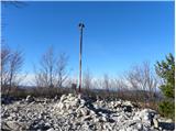
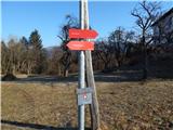
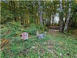
 | Lokev - Stari tabor
Stari tabor is a scenic peak located west of Divača, north of Lokev and south of the village of Povir. From the summit, where the stamp and the r...
45 min |
| Vilenica - Stari tabor
Stari tabor is a scenic peak located west of Divača, north of Lokev and south of the village of Povir. From the summit, where the stamp and the r...
45 min |
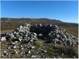
| Povir - Stari tabor
Stari tabor is a scenic peak located west of Divača, north of Lokev and south of the village of Povir. From the summit, where the stamp and the r...
1 h 10 min |
 | Povir - Stari tabor (harder path)
Stari tabor is a scenic peak located west of Divača, north of Lokev and south of the village of Povir. From the summit, where the stamp and the r...
1 h 15 min |
 | Ljubljana (Gruberjeva brv) - Mazovnik (Golovec)
At 450 m, Mazovnik is the highest peak of Golovec, a hill located in the south-eastern part of Ljubljana. Golovec was unforested until the end of...
1 h |
 | Mekinje nad Stično - Sveti Lambert
Sveti Lambert is located on an inconspicuous peak near the village of Pristava above Stično. From the top of the hill, where the castle of the Du...
1 h 5 min |
 | Preval Prosca - Visoki hrib
Visoki hrib is a 602 m high hill located south of Polhov Gradec. The summit, partly covered by forest, offers a beautiful view, especially to the...
50 min |
 | Zazid - Kuk
Kuk (also Ščukovec on some maps) is a 498 m high hill located north of the village of Movraž. From the top, where a small cross stands, you can e...
1 h |
 | Zazid - Veliki Gradež
Veliki Gradež is a 507 m high hill located between Zazid and Movraz. From the top, set amidst vast pastures, you can enjoy a beautiful view of th...
45 min |
 | Šentilj v Slovenskih goricah - Plački vrh
Plački vrh is a peak in Slovenske Gorice. It lies in the municipality of Kungota, right on the border with Austria.It has a 28-metre-high lookout...
1 h |
 | Repnje - Smledniški hrib (Stari grad)
The Old Castle (also Smlednik Castle) is located on a small hill south-west of Valburg. A few years ago, the castle was rebuilt and the nearby tr...
1 h 15 min |
 | Dragomer - Strmca (via Ferjanka)
Strmca is a lesser-known and forested hill located between Brezje pri Dobrovi and Log pri Brezovici. There is no view from the top due to the for...
45 min |
 | Gaber pri Semiču - Smuk (via Semenič)
Smuk is a 545-metre-high peak located above Semič. On the top there is the Church of St. Lawrence, a hunting lodge, and a little further away the...
1 h 10 min |
| Gaber pri Semiču - Smuk (via Smuška cesta)
Smuk is a 545-metre-high peak located above Semič. On the top there is the Church of St. Lawrence, a hunting lodge, and a little further away the...
50 min |
 | Ressnig - Aussicht Petelinz
Aussicht Petelinz is located north-east of Borovel / Ferlach and north or directly above the river Drava / Drau. From the lookout point where the...
1 h |
 | Kamnik - Sveta Ana (Tunjice)
The Baroque church of St Anne in Tunjice is located on a hill west of Kamnik. Near the church there is a registration box, and a little further a...
1 h |
 | Treskavac - Veli Vrh
Veli Vrh is not the highest peak on the island of Krk, but it offers the best view of the whole island, the Gulf of Reška / Gulf of Rijeka, Učki ...
50 min |
| Vratca - Štanjel (Sveti Danijel) (Vratca - Sv. Danijel (Štanjel))
Štanjel (Sveti Danijel) is located east of Škabrijel (646 m). On the summit are the remains of WWI positions and trenches. On the top there is a...
1 h |
 | Špitalič pri Slovenskih Konjicah - Babček
Babček, an undistinguished peak on the mountain trail between Konjiška Gora and Boč. An asphalt road leads practically under the peak itself. The...
50 min |
 | Ljubljana (Žabja vas) - Orle
Orle is a locality in the municipality of Lavrica, located on a small hill northeast of the Ljubljana Mor. A few metres below the highest point o...
1 h 15 min |
| Ljubljana (Sveti Urh) - Orle
Orle is a locality in the municipality of Lavrica, located on a small hill northeast of the Ljubljana Mor. A few metres below the highest point o...
1 h 10 min |
 | Rdeči Kal - Ostri vrh (above Globodol) (via Dom LD Dobrnič)
Ostri vrh is a 523 m high peak located between Vrbovec, Rdeči Kal, Gorenji, Sredni and Dolenji Globodol, Dolni and Gorni Ajdovec and Podlipa. The...
1 h |
 | Čatež - Bajturn (Zaplaški hrib) (on north slope)
At 609 metres, Bajturn or Zaplaz Hill is the highest peak in the municipality of Trebnje. At the top there is a nice bench with a table, a box wi...
50 min |
 | Kamna Gorica - Lipnica Castle (Pusti grad above Lipnica) (via Galerije)
Castle Lipniški grad or Pusti grad above Lipnica (Waldenberg in German) is located on a lookout over the Sava and Lipnica watercourses, more prec...
45 min |
 | Aussichtswarte Vulkanland - Stradner Kogel
Stradner Kogel is the highest hill in south-eastern Styria. The hill is of volcanic origin, and its vegetation prevents views in any direction. O...
45 min |
 | Suhadole - Koseški hrib (via Mlinčki)
Koseški hrib is located between Kuharjevi boršt' and Kosezami, the settlement after which the peak is named. From the top, where there is a table...
50 min |
| Bukovica pri Vodicah - Koseški hrib (via Mlinčki)
Koseški hrib is located between Kuharjevi boršt' and Kosezami, the settlement after which the peak is named. From the top, where there is a table...
50 min |
 | Topole - Koseški hrib
Koseški hrib is located between Kuharjevi boršt' and Kosezami, the settlement after which the peak is named. From the top, where there is a table...
55 min |
 | Dravograd lake - Church of the Holy Cross at Dravograd
The Church of the Holy Cross at Dravograd church is situated on a lookout hill, which offers a beautiful view of the western Pohorje, the Slovenj...
45 min |
 | Lovnik - Ljubična gora
Ljubična gora is a hill located above Ljubično, Zbelovo and Zbelovo Gora. The hill is hidden in the forest and is not very visible, but the churc...
45 min |
 | Liboje - Kamčič (via organic farm Kralj - southern approach)
Kamčič is a vegetated peak in Posavsko hribovje, located north of Šmohor, between Kotečnik on the left and Veliki Slomnik on the right. It can be...
1 h 10 min |
 | Brezje pri Dobrovi - Vrhovčev grič (via Strmca)
Vrhovčev grič is a nondescript and forested peak located only a few metres away from the marked path between Debeli hill and Strmca....
50 min |
| Dragomer (bajer) - Vrhovčev grič (via Ferjanka and Strmca)
Vrhovčev grič is a nondescript and forested peak located only a few metres away from the marked path between Debeli hill and Strmca....
1 h 10 min |
 | Velenje (Stari trg) - Malo Gradišče (on mountain trail)
Gradišče is a hill above Pesje near Velenje. It has two peaks, Veliko and Malo Gradišče. Malo Gradišče is located to the east of the church of St...
45 min |
 | Velenje (Stari trg) - Veliko Gradišče
Gradišče is a hill above Pesje near Velenje. It has two peaks, Veliko and Malo Gradišče. Veliko Gradišče is located to the west of the Church of ...
1 h |
 | Zreče (Terme Zreče) - Sveti Martin (Zlakova) (on PP1)
St Martin's Church is situated on a lookout on the outskirts of Zlakova. From the church you can enjoy a beautiful view of the Pohorje, Brinjeva ...
55 min |
 | Rechnitz (Badesee) - Donatikappele (above Rechnitz)
The Chapel of St Donatus is located on a small hill to the north-west of Rechnitz....
45 min |
 | Tourist farm Žurej - Church of St. Helena on Javor
...
45 min |
 | Borovic (road on Hum) - Sveti Duh (Hum) (past Titova špilja)
...
50 min |
 | Snack Bar Zelena dolina - Church of Our Lady of Loreto in Ložno
...
1 h 5 min |
| Brzika - Church of Our Lady of Loreto in Ložno
...
55 min |
 | Loka pri Žusmu (Žamerk) - Castle Žusem
...
50 min |
 | Veliki Erjavec - Vodenica
...
45 min |