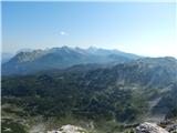
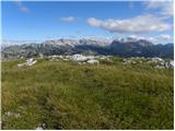
 | Tinčkova koča - Hochstuhl/Stol (via Zagon)
At 2236 m, Stol is the highest peak in the Karavanke Mountains. From the summit, which has a registration box and a stamp, we have a beautiful vi...
3 h 45 min |
 | Tinčkova koča - Hochstuhl/Stol (via hunting cottage above Doslovška planina)
At 2236 m, Stol is the highest peak in the Karavanke Mountains. From the summit, which has a registration box and a stamp, we have a beautiful vi...
3 h 40 min |
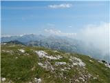
 | Rosenbach - Frauenkogel/Dovška Baba (via Hruški vrh)
Frauenkogel is an 1891 m high peak located on the border ridge between Slovenia and Austria. The summit, which has a registration box and a stamp...
4 h 40 min |
| Rosenbach - Frauenkogel/Dovška Baba (via Koprivnjak)
Frauenkogel is an 1891 m high peak located on the border ridge between Slovenia and Austria. The summit, which has a registration box and a stamp...
4 h 30 min |
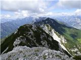
 | Smrečje - Plešivec (by road)
Plešivec is an 1801 m high peak located south of the eastern part of Košuta. The summit, on which the border signpost stands, offers a beautiful ...
3 h 30 min |
 | Za Loncem - Deska (Veža)
Deska is a scenic peak located in the heart of the Dleskovška Plateau or Veža. From the top, where a large cairn stands, we have a beautiful view...
3 h 30 min |
 | Za Loncem - Tolsti vrh (Veža)
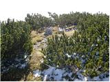
Tolsti vrh is a 1985 m high mountain located in the heart of the Dleskovská Plateau - Veže. The summit, which is covered with dwarf pines, offers...
3 h 35 min |
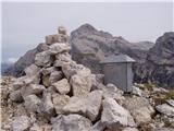
 | Tinčkova koča - Prešernova koča na Stolu (via hunting cottage above Doslovška planina)
Prešernova koča na Stolu, is located just a few metres below the summit of the 2198 m high Mali Stol. From the hut or the nearby Mali Stol, we ha...
3 h 25 min |
 | Rosenbach - Klek
Klek is a 1753 m high mountain located between Rosenkogel and the more famous Golica. The summit, which borders between Slovenia and Austria, off...
3 h 40 min |
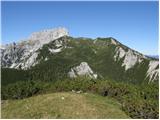
 | Gate (Belca) - Techantinger Mittagskogel (Trupejevo poldne) (by road)
The mountain is located on the border with Austria and is above Gozd Martuljko. From the uncultivated summit there is a beautiful view of Julian ...
4 h |
| Srednji vrh - Techantinger Mittagskogel (Trupejevo poldne) (via Grajšca)
The mountain is located on the border with Austria and is above Gozd Martuljko. From the uncultivated summit there is a beautiful view of Julian ...
4 h |
 | Dom v Lepeni - Batognica (via Prag)
Batognica is a 2164 m high mountain, which was affected by the Mine War during World War I. Remnants of the mine war between the Italians and the...
4 h 45 min |
 | Dom Trilobit - Weinasch/Vajnež (via Rida)
Weinasch is the highest peak of Belščice, a mountain range located to the west of the better known Stoľa. From the top, where the cross and the S...
4 h |
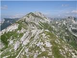
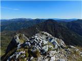
 | Planina Blato - Velika Zelnarica (Za Kopico)
Velika Zelnarica is a 2320 m high peak located to the west of the Vrata Pass, the pass that separates the Triglav Lakes Valley from the Za Kopica...
4 h 30 min |
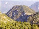 | Mojstrana - Drobeče Sleme
The summit is located in the same ridge as the better known Sleme. There is also a registration box with a registration book on the lookout point...
4 h 15 min |
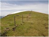
 | Mojstrana - Vrtaški vrh (old path)
Vrtaški vrh is a scenic mountain overloking the Vrata valley. From the grassy summit, which is covered around and around with dwarf pines, there ...
3 h 30 min |
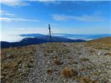
 | Trbiž / Tarviso - Svete Višarje / Monte Lussari (on transport road)
Svete Višarje is a pilgrimage site for Slavs, Germans and Romans. As early as the 16th century, the mountain was called the God's Way of the Thre...
3 h 25 min |
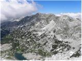
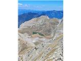
 | Koča pri Savici - Velika Baba (via Velika Montura)
Velika Baba is the highest peak of the eastern ridge above the Lepena valley. From the summit, which has a registration box, there is a beautiful...
5 h 35 min |
 | Zadnjica - Zadnjiški Ozebnik
Zadnjiški Ozebnik is a little-known mountain above the valley of Zadnjica. As there is no marked trail leading to the summit, we are in peace at ...
4 h 15 min |
 | Kneške Ravne - Vrh Planje (above Globoko)
Vrh Planje is a less distinct peak in the ridge of the Lower Bohinj Mountains, which has recently become more and more visited. Vrh Planje (above...
4 h 30 min |
 | Weissensee - Kopasnock (via Karalm)
Kopasnock is a lesser known peak in the Latschur group reached by an unmarked route. The grassy peak offers a beautiful view of Gailtaler Alps, C...
4 h |
 | Javorje - Raskovec (via Rodica)
Raskovec is a scenic mountain located between the better known Rodica and the Black Earth. From this little-visited peak, which has no registrati...
3 h 45 min |
| Rutarski gozd - Raskovec (via Rodica)
Raskovec is a scenic mountain located between the better known Rodica and the Black Earth. From this little-visited peak, which has no registrati...
3 h 30 min |
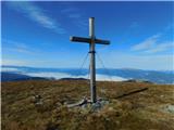
 | Rudnik v Topli - Feistritzer Spitze
Feistritzer Spitze is a 2113 m high peak located on the Austrian side of Pec. From the top on which the cross stands, you have a beautiful view o...
3 h 30 min |
 | Koča pri Savici - Vrh Škrli
Vrh Škrli is a 1926 m high mountain located above the Lower Komna plateau. The grassy peak, which once was the site of the national border, offer...
4 h 35 min |
 | Petrovo Brdo - Rušni vrh
Rušni vrh is a 1786 m high peak located to the east of Črna prsti. From the summit, which is the boundary stone of the old Rapallo border, we hav...
4 h 30 min |
 | Jasna - Visoka peč (via Mojčin dom)
Visoka peč is a 1,749-metre-high mountain located south-west of Ciprnik. From the top, which descends steeply towards Planica and on which a smal...
3 h 30 min |
| Kranjska Gora - Visoka peč (via Bedančev dom)
Visoka peč is a 1,749-metre-high mountain located south-west of Ciprnik. From the top, which descends steeply towards Planica and on which a smal...
3 h 25 min |
 | Dom v Lepeni - Velika Montura
Velika Montura is a scenic peak located between Velika Baba, Lanževica, Bogatin and Veliki Šmohorje. Just below the summit are old Italian carava...
3 h 55 min |
 | Ombrico - Monte Gosadon
Monte Gosadon is a slightly less visited peak in the Naborjeta group. There are also a number of World War I remains in the vicinity of the peak....
3 h 40 min |
 | Parkirišče Hoyer (Neuhofgraben) - Speikkogel (Gleinalpe) (čez Kreuzsattel)
...
4 h 10 min |
 | Parkirišče Hoyer (Neuhofgraben) - Lenzmoarkogel (Gleinalpe) (čez Kreuzsattel)
...
4 h 25 min |
 | Mikro Papingo - Astraka
...
4 h |
 | Aflenz Kurort (Freibad Aflenz) - Hochstein (at Mitteralm) (čez Windgrube)
...
3 h 35 min |
| Aflenz Kurort (Bürgergraben) - Hochstein (at Mitteralm) (čez Windgrube)
...
3 h 35 min |